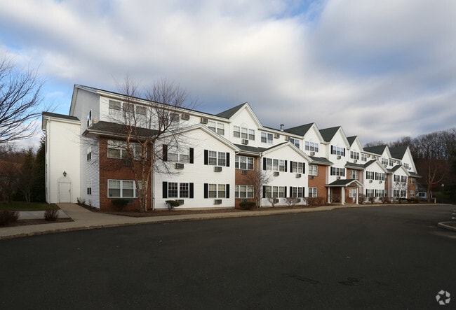
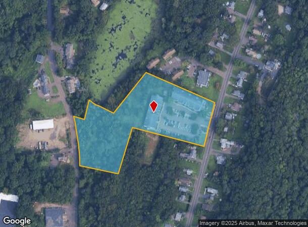
Property Record
216 Laurel St, East Haven, CT 06512

NEARBY LISTINGS FOR SALE OR LEASE
Property Detail
216 Laurel St
R0177600
New Haven
Apartmenthouse5plusunits
Connecticut
A
1
09009C0461J
5.43 AC
2025
Outer East Haven
2025
Westchester/So Connecticut
180400
New Haven-Milford, CT
DEMOGRAPHICS near 216 Laurel St
1 Mile
3 Mile
5 Mile
2024 Total Population
7,786
87,651
216,531
2029 Population
7,755
86,890
214,805
Pop Growth 2024-2029
(0.40%)
(0.87%)
(0.80%)
Average Age
41
40
39
2024 Total Households
3,177
37,358
87,271
HH Growth 2024-2029
(0.47%)
(0.75%)
(0.72%)
Median Household Inc
$52,156
$62,694
$60,211
Avg Household Size
2.40
2.30
2.30
2024 Avg HH Vehicles
2.00
1.00
1.00
Median Home Value
$240,132
$248,408
$256,592
Median Year Built
1971
1963
1958
Nearby Places
Map Layers
Map Styles
 Street
 Aerial
- Restaurants
- Banks
- Shops
- Fitness
- Groceries
PUBLIC TRANSPORTATION
COMMUTER RAIL
New Haven-State Street Station (Hartford Line - CONN DOT, New Haven Line - CONN DOT, Shore Line East - CONN DOT)
DRIVE
WALK
Distance
New Haven-State Street Station (Hartford Line - CONN DOT, New Haven Line - CONN DOT, Shore Line East - CONN DOT)
8 min
4.1 mi
New Haven-Union Station (New Haven Line - Shore Line East, Shore Line East - Shore Line East)
DRIVE
WALK
Distance
New Haven-Union Station (New Haven Line - Shore Line East, Shore Line East - Shore Line East)
8 min
4.4 mi
AIRPORT
Tweed/New Haven
DRIVE
WALK
Distance
Tweed/New Haven
6 min
2.1 mi
Freight Ports
Port of New Haven
DRIVE
WALK
Distance
Port of New Haven
7 min
3.0 mi
Nearby Properties
Address
Land Use
TOTAL SIZE
Lot Size
Zoning
Address
Land Use
TOTAL SIZE
Lot Size
Zoning
83,314 SF
2.14 AC
BA
Address
Land Use
TOTAL SIZE
Lot Size
Zoning
446,320 SF
BD1
Address
Land Use
TOTAL SIZE
Lot Size
Zoning
122,856 SF
1.66 AC
RH2
Address
Land Use
TOTAL SIZE
Lot Size
Zoning
258,313 SF
23.50 AC
PDU 34
Address
Land Use
TOTAL SIZE
Lot Size
Zoning
318,210 SF
2.73 AC
BA
Address
Land Use
TOTAL SIZE
Lot Size
Zoning
2.55 AC
BD
Address
Land Use
TOTAL SIZE
Lot Size
Zoning
78,878 SF
3.12 AC
RM2
Address
Land Use
TOTAL SIZE
Lot Size
Zoning
68,706 SF
3.34 AC
BA1
Address
Land Use
TOTAL SIZE
Lot Size
Zoning
7,345 SF
3.09 AC
IL/RM2
Address
Land Use
TOTAL SIZE
Lot Size
Zoning
72,007 SF
1.79 AC
RS2
Address
Land Use
TOTAL SIZE
Lot Size
Zoning
117,066 SF
71.34 AC
IH
Address
Land Use
TOTAL SIZE
Lot Size
Zoning
287,844 SF
2.11 AC
IL
Address
Land Use
TOTAL SIZE
Lot Size
Zoning
8,655 SF
107.61 AC
AIRPOR
Address
Land Use
TOTAL SIZE
Lot Size
Zoning
163,505 SF
3.96 AC
BA1
Address
Land Use
TOTAL SIZE
Lot Size
Zoning
85,679 SF
14.23 AC
RM1
Address
Land Use
TOTAL SIZE
Lot Size
Zoning
88,689 SF
0.98 AC
BD
Address
Land Use
TOTAL SIZE
Lot Size
Zoning
495,934 SF
0.61 AC
BD
Address
Land Use
TOTAL SIZE
Lot Size
Zoning
111,576 SF
2.51 AC
RM2
Address
Land Use
TOTAL SIZE
Lot Size
Zoning
126,430 SF
10.63 AC
RM1
Address
Land Use
TOTAL SIZE
Lot Size
Zoning
185,600 SF
1.44 AC
BA
Address
Land Use
TOTAL SIZE
Lot Size
Zoning
143,976 SF
0.86 AC
BD
Address
Land Use
TOTAL SIZE
Lot Size
Zoning
194,140 SF
1.50 AC
BD3
Address
Land Use
TOTAL SIZE
Lot Size
Zoning
197.78 AC
LI-3
Address
Land Use
TOTAL SIZE
Lot Size
Zoning
55,532 SF
0.79 AC
RM2
Address
Land Use
TOTAL SIZE
Lot Size
Zoning
97,057 SF
2.78 AC
RM2
Address
Land Use
TOTAL SIZE
Lot Size
Zoning
297,601 SF
16.70 AC
PDD 10
Address
Land Use
TOTAL SIZE
Lot Size
Zoning
199,716 SF
0.54 AC
BD
Address
Land Use
TOTAL SIZE
Lot Size
Zoning
25,590 SF
4.50 AC
BE
Address
Land Use
TOTAL SIZE
Lot Size
Zoning
64,240 SF
7.33 AC
BE
Address
Land Use
TOTAL SIZE
Lot Size
Zoning
82,198 SF
1.01 AC
BD
The World's #1 Commercial Real Estate Marketplace
Connect with us
© 2025 CoStar Group
The information above has been obtained from sources believed reliable. While we do not doubt its accuracy we have not verified it and make no guarantee, warranty or representation about it. It is your responsibility to independently confirm its accuracy and completeness. Any projections, opinions, assumptions, or estimates used are for example only and do not represent the current or future performance of the property. The value of this transaction to you depends on tax and other factors which should be evaluated by your tax, financial, and legal advisors. You and your advisors should conduct a careful, independent investigation of the property to determine to your satisfaction the suitability of the property for your needs.