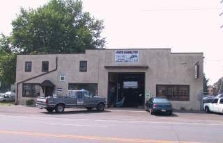
Property Record
2161 Nottingham Way, Trenton, NJ 08619

NEARBY LISTINGS FOR SALE OR LEASE
Property Detail
2161 Nottingham Way
03-01772-0000-00017
00950-
Commercialnec
Mercer
X
New Jersey
34021C0227F
17
2024
1.81 AC
2025
Trenton
003008
Northern New Jersey
4,792 SF
Trenton, NJ
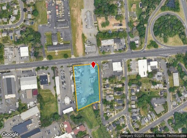
DEMOGRAPHICS near 2161 Nottingham Way
1 Mile
3 Mile
5 Mile
2024 Total Population
8,974
123,898
245,793
2029 Population
8,784
121,411
242,653
Pop Growth 2024-2029
(2.12%)
(2.01%)
(1.28%)
Average Age
44
39
40
2024 Total Households
3,725
44,732
90,440
HH Growth 2024-2029
(2.12%)
(2.07%)
(1.37%)
Median Household Inc
$79,746
$73,591
$74,125
Avg Household Size
2.30
2.70
2.60
2024 Avg HH Vehicles
2.00
2.00
2.00
Median Home Value
$268,632
$245,961
$253,221
Median Year Built
1960
1956
1958
Nearby Places
Map Layers
Map Styles
 Street
 Aerial
- Restaurants
- Banks
- Shops
- Fitness
- Groceries
PUBLIC TRANSPORTATION
COMMUTER RAIL
Hamilton (Northeast Corridor Line - NJ Transit Commuter Rail (NJ Transit))
DRIVE
WALK
Distance
Hamilton (Northeast Corridor Line - NJ Transit Commuter Rail (NJ Transit))
6 min
2.1 mi
DRIVE
WALK
Distance
7 min
3.4 mi
AIRPORT
Trenton Mercer
DRIVE
WALK
Distance
Trenton Mercer
19 min
8.3 mi
Philadelphia International
DRIVE
WALK
Distance
Philadelphia International
65 min
48.9 mi
Freight Ports
Port of Philadelphia
DRIVE
WALK
Distance
Port of Philadelphia
49 min
34.7 mi
Nearby Properties
Address
Land Use
TOTAL SIZE
Lot Size
Zoning
Address
Land Use
TOTAL SIZE
Lot Size
Zoning
5.38 AC
MU
Address
Land Use
TOTAL SIZE
Lot Size
Zoning
Address
Land Use
TOTAL SIZE
Lot Size
Zoning
35.83 AC
RB
Address
Land Use
TOTAL SIZE
Lot Size
Zoning
56.45 AC
EGI
Address
Land Use
TOTAL SIZE
Lot Size
Zoning
161,080 SF
2.21 AC
BA
Address
Land Use
TOTAL SIZE
Lot Size
Zoning
18.33 AC
Address
Land Use
TOTAL SIZE
Lot Size
Zoning
17.84 AC
HC
Address
Land Use
TOTAL SIZE
Lot Size
Zoning
21.19 AC
B-H
Address
Land Use
TOTAL SIZE
Lot Size
Zoning
Address
Land Use
TOTAL SIZE
Lot Size
Zoning
44.83 AC
I
Address
Land Use
TOTAL SIZE
Lot Size
Zoning
21.17 AC
I
Address
Land Use
TOTAL SIZE
Lot Size
Zoning
4.07 AC
MU
Address
Land Use
TOTAL SIZE
Lot Size
Zoning
9.63 AC
RD
Address
Land Use
TOTAL SIZE
Lot Size
Zoning
16.86 AC
EG1
Address
Land Use
TOTAL SIZE
Lot Size
Zoning
27.50 AC
R7
Address
Land Use
TOTAL SIZE
Lot Size
Zoning
Address
Land Use
TOTAL SIZE
Lot Size
Zoning
82,244 SF
5.35 AC
IA
Address
Land Use
TOTAL SIZE
Lot Size
Zoning
6.79 AC
R7
Address
Land Use
TOTAL SIZE
Lot Size
Zoning
47.84 AC
HC
Address
Land Use
TOTAL SIZE
Lot Size
Zoning
15.80 AC
C
Address
Land Use
TOTAL SIZE
Lot Size
Zoning
157,952 SF
0.80 AC
BB
Address
Land Use
TOTAL SIZE
Lot Size
Zoning
173,385 SF
1.78 AC
MU
Address
Land Use
TOTAL SIZE
Lot Size
Zoning
156,128 SF
6.33 AC
RB
Address
Land Use
TOTAL SIZE
Lot Size
Zoning
Address
Land Use
TOTAL SIZE
Lot Size
Zoning
Address
Land Use
TOTAL SIZE
Lot Size
Zoning
Address
Land Use
TOTAL SIZE
Lot Size
Zoning
17,500 SF
18.14 AC
HC
Address
Land Use
TOTAL SIZE
Lot Size
Zoning
9.31 AC
HC
Address
Land Use
TOTAL SIZE
Lot Size
Zoning
456,860 SF
2.46 AC
BB
Address
Land Use
TOTAL SIZE
Lot Size
Zoning
16.62 AC
The World's #1 Commercial Real Estate Marketplace
Connect with us
© 2025 CoStar Group
The information above has been obtained from sources believed reliable. While we do not doubt its accuracy we have not verified it and make no guarantee, warranty or representation about it. It is your responsibility to independently confirm its accuracy and completeness. Any projections, opinions, assumptions, or estimates used are for example only and do not represent the current or future performance of the property. The value of this transaction to you depends on tax and other factors which should be evaluated by your tax, financial, and legal advisors. You and your advisors should conduct a careful, independent investigation of the property to determine to your satisfaction the suitability of the property for your needs.