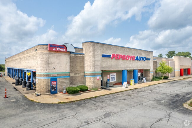
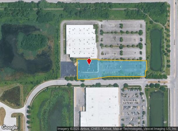
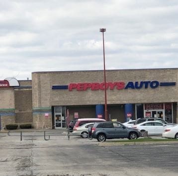
Property Record
21610 S Cicero Ave, Matteson, IL 60443
NEARBY LISTINGS FOR SALE OR LEASE
Property Detail
21610 S Cicero Ave
31-28-201-004-0000
Southgate Commerce Ctr 03
Commercialbuilding
Cook
X
Illinois
17031C0801J
2
2023
2.81 AC
2025
Far South
830006
Chicago
21,877 SF
Chicago-Naperville-Elgin, IL-IN-WI
DEMOGRAPHICS near 21610 S Cicero Ave
1 Mile
3 Mile
5 Mile
2024 Total Population
3,090
51,032
141,779
2029 Population
3,015
49,872
139,437
Pop Growth 2024-2029
(2.43%)
(2.27%)
(1.65%)
Average Age
41
42
41
2024 Total Households
1,129
19,231
52,477
HH Growth 2024-2029
(2.66%)
(2.55%)
(2.01%)
Median Household Inc
$70,839
$72,500
$73,867
Avg Household Size
2.70
2.60
2.60
2024 Avg HH Vehicles
2.00
2.00
2.00
Median Home Value
$167,289
$169,779
$187,904
Median Year Built
1981
1977
1975
Nearby Places
Map Layers
Map Styles
 Street
 Aerial
- Restaurants
- Banks
- Shops
- Fitness
- Groceries
PUBLIC TRANSPORTATION
COMMUTER RAIL
Richton Park Station (Metra Electric Line - Northeast Illinois Regional Commuter Railroad (Metra))
DRIVE
WALK
Distance
Richton Park Station (Metra Electric Line - Northeast Illinois Regional Commuter Railroad (Metra))
6 min
2.4 mi
Matteson Station (Metra Electric Line - Northeast Illinois Regional Commuter Railroad (Metra))
DRIVE
WALK
Distance
Matteson Station (Metra Electric Line - Northeast Illinois Regional Commuter Railroad (Metra))
7 min
2.9 mi
AIRPORT
Chicago Midway International
DRIVE
WALK
Distance
Chicago Midway International
35 min
21.3 mi
Freight Ports
Port Milwaukee
DRIVE
WALK
Distance
Port Milwaukee
143 min
115.0 mi
SALE & LEASE HISTORY
LISTING DATE
SALE/LEASE

Nov 03, 2022
For Lease
May 25, 2021
For Lease
Nearby Properties
Address
Land Use
TOTAL SIZE
Lot Size
Zoning
Address
Land Use
TOTAL SIZE
Lot Size
Zoning
757,504 SF
46.30 AC
Address
Land Use
TOTAL SIZE
Lot Size
Zoning
575,024 SF
39.03 AC
Address
Land Use
TOTAL SIZE
Lot Size
Zoning
Address
Land Use
TOTAL SIZE
Lot Size
Zoning
37.62 AC
Address
Land Use
TOTAL SIZE
Lot Size
Zoning
455,870 SF
23.32 AC
Address
Land Use
TOTAL SIZE
Lot Size
Zoning
Address
Land Use
TOTAL SIZE
Lot Size
Zoning
Address
Land Use
TOTAL SIZE
Lot Size
Zoning
Address
Land Use
TOTAL SIZE
Lot Size
Zoning
72,668 SF
3 AC
Address
Land Use
TOTAL SIZE
Lot Size
Zoning
194,292 SF
21.10 AC
Address
Land Use
TOTAL SIZE
Lot Size
Zoning
Address
Land Use
TOTAL SIZE
Lot Size
Zoning
70.02 AC
Address
Land Use
TOTAL SIZE
Lot Size
Zoning
150,289 SF
16.40 AC
Address
Land Use
TOTAL SIZE
Lot Size
Zoning
173,415 SF
14.97 AC
Address
Land Use
TOTAL SIZE
Lot Size
Zoning
300,399 SF
26.50 AC
Address
Land Use
TOTAL SIZE
Lot Size
Zoning
11.84 AC
Address
Land Use
TOTAL SIZE
Lot Size
Zoning
192,369 SF
22.05 AC
Address
Land Use
TOTAL SIZE
Lot Size
Zoning
1,201 SF
3.65 AC
Address
Land Use
TOTAL SIZE
Lot Size
Zoning
224,611 SF
0.90 AC
Address
Land Use
TOTAL SIZE
Lot Size
Zoning
322,629 SF
53.73 AC
Address
Land Use
TOTAL SIZE
Lot Size
Zoning
8,920 SF
38.44 AC
Address
Land Use
TOTAL SIZE
Lot Size
Zoning
2.94 AC
Address
Land Use
TOTAL SIZE
Lot Size
Zoning
4,168 SF
145.94 AC
Address
Land Use
TOTAL SIZE
Lot Size
Zoning
15.65 AC
Address
Land Use
TOTAL SIZE
Lot Size
Zoning
2.04 AC
Address
Land Use
TOTAL SIZE
Lot Size
Zoning
3.65 AC
Address
Land Use
TOTAL SIZE
Lot Size
Zoning
250,656 SF
Address
Land Use
TOTAL SIZE
Lot Size
Zoning
130,753 SF
8.12 AC
Address
Land Use
TOTAL SIZE
Lot Size
Zoning
3,011 SF
125.12 AC
Address
Land Use
TOTAL SIZE
Lot Size
Zoning
37,522 SF
2.78 AC
The World's #1 Commercial Real Estate Marketplace
Connect with us
© 2026 CoStar Group
The information above has been obtained from sources believed reliable. While we do not doubt its accuracy we have not verified it and make no guarantee, warranty or representation about it. It is your responsibility to independently confirm its accuracy and completeness. Any projections, opinions, assumptions, or estimates used are for example only and do not represent the current or future performance of the property. The value of this transaction to you depends on tax and other factors which should be evaluated by your tax, financial, and legal advisors. You and your advisors should conduct a careful, independent investigation of the property to determine to your satisfaction the suitability of the property for your needs.