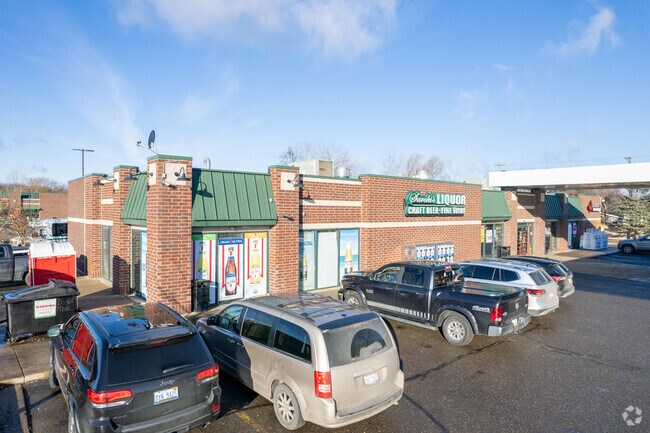
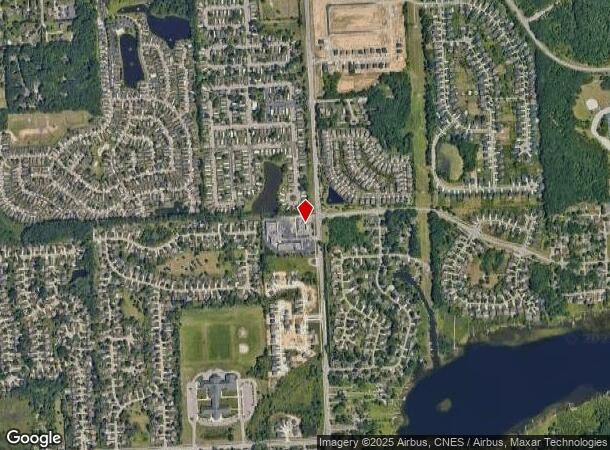
Property Record
2163 N Wixom Rd, Wixom, MI 48393

NEARBY LISTINGS FOR SALE OR LEASE
Property Detail
2163 N Wixom Rd
17-30-200-016
T2N, R8E, SEC 30 PART OF NE 1/4 BEG AT PT DIST N 00-00-02 E 2165.76 FT & N 89-52-41 W 60 FT & N 00-00-02 E 225 FT FROM E 1/4
Supermarket
Oakland
X
Michigan
26125C0466F
1.13 AC
2024
Central I-96 Corridor
2024
Detroit
133001
Detroit-Warren-Dearborn, MI
6,675 SF
DEMOGRAPHICS near 2163 N Wixom Rd
1 Mile
3 Mile
5 Mile
2024 Total Population
7,099
39,132
97,062
2029 Population
7,020
38,322
95,746
Pop Growth 2024-2029
(1.11%)
(2.07%)
(1.36%)
Average Age
39
40
41
2024 Total Households
2,581
17,378
40,265
HH Growth 2024-2029
(1.24%)
(2.43%)
(1.57%)
Median Household Inc
$109,678
$74,873
$87,707
Avg Household Size
2.70
2.20
2.40
2024 Avg HH Vehicles
2.00
2.00
2.00
Median Home Value
$293,308
$308,765
$333,911
Median Year Built
1992
1987
1989
Nearby Places
Map Layers
Map Styles
 Street
 Aerial
- Restaurants
- Banks
- Shops
- Fitness
- Groceries
PUBLIC TRANSPORTATION
AIRPORT
Detroit Metro Wayne County
DRIVE
WALK
Distance
Detroit Metro Wayne County
42 min
33.8 mi
Freight Ports
Port of Toledo
DRIVE
WALK
Distance
Port of Toledo
92 min
75.5 mi
Nearby Properties
Address
Land Use
TOTAL SIZE
Lot Size
Zoning
Address
Land Use
TOTAL SIZE
Lot Size
Zoning
873,288 SF
Address
Land Use
TOTAL SIZE
Lot Size
Zoning
72.63 AC
RM-1
Address
Land Use
TOTAL SIZE
Lot Size
Zoning
86.19 AC
RC2
Address
Land Use
TOTAL SIZE
Lot Size
Zoning
563,160 SF
47.06 AC
Address
Land Use
TOTAL SIZE
Lot Size
Zoning
59.71 AC
RM-1
Address
Land Use
TOTAL SIZE
Lot Size
Zoning
38.85 AC
RC2
Address
Land Use
TOTAL SIZE
Lot Size
Zoning
4,140 SF
120 AC
MM
Address
Land Use
TOTAL SIZE
Lot Size
Zoning
126,720 SF
8.31 AC
Address
Land Use
TOTAL SIZE
Lot Size
Zoning
7,471 SF
114.63 AC
MM
Address
Land Use
TOTAL SIZE
Lot Size
Zoning
26.54 AC
RM-1
Address
Land Use
TOTAL SIZE
Lot Size
Zoning
200,926 SF
30.87 AC
M1
Address
Land Use
TOTAL SIZE
Lot Size
Zoning
14.93 AC
RC2
Address
Land Use
TOTAL SIZE
Lot Size
Zoning
132,101 SF
Address
Land Use
TOTAL SIZE
Lot Size
Zoning
2,080 SF
68.30 AC
MM
Address
Land Use
TOTAL SIZE
Lot Size
Zoning
223,361 SF
15.66 AC
M1
Address
Land Use
TOTAL SIZE
Lot Size
Zoning
13.16 AC
RC2
Address
Land Use
TOTAL SIZE
Lot Size
Zoning
Address
Land Use
TOTAL SIZE
Lot Size
Zoning
18.54 AC
RM-1
Address
Land Use
TOTAL SIZE
Lot Size
Zoning
236,821 SF
15.45 AC
AI
Address
Land Use
TOTAL SIZE
Lot Size
Zoning
202,500 SF
9.30 AC
M1
Address
Land Use
TOTAL SIZE
Lot Size
Zoning
193,500 SF
9.44 AC
M1
Address
Land Use
TOTAL SIZE
Lot Size
Zoning
8.05 AC
RM-1
Address
Land Use
TOTAL SIZE
Lot Size
Zoning
99,392 SF
II
Address
Land Use
TOTAL SIZE
Lot Size
Zoning
130,091 SF
8.10 AC
M1
Address
Land Use
TOTAL SIZE
Lot Size
Zoning
95,846 SF
Address
Land Use
TOTAL SIZE
Lot Size
Zoning
117,826 SF
12.89 AC
M-1
Address
Land Use
TOTAL SIZE
Lot Size
Zoning
103,503 SF
20.57 AC
AI
Address
Land Use
TOTAL SIZE
Lot Size
Zoning
76,252 SF
9.72 AC
B-3
Address
Land Use
TOTAL SIZE
Lot Size
Zoning
104,053 SF
7.13 AC
M1
Address
Land Use
TOTAL SIZE
Lot Size
Zoning
98,537 SF
9.92 AC
The World's #1 Commercial Real Estate Marketplace
Connect with us
© 2025 CoStar Group
The information above has been obtained from sources believed reliable. While we do not doubt its accuracy we have not verified it and make no guarantee, warranty or representation about it. It is your responsibility to independently confirm its accuracy and completeness. Any projections, opinions, assumptions, or estimates used are for example only and do not represent the current or future performance of the property. The value of this transaction to you depends on tax and other factors which should be evaluated by your tax, financial, and legal advisors. You and your advisors should conduct a careful, independent investigation of the property to determine to your satisfaction the suitability of the property for your needs.