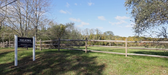
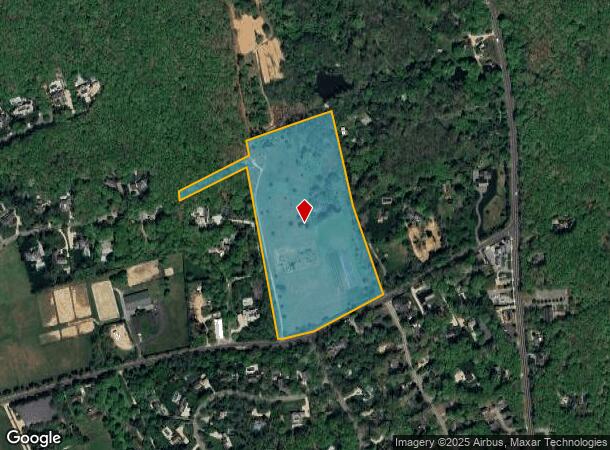
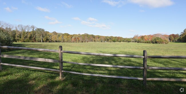
Property Record
2166 Scuttle Hole Rd, Bridgehampton, NY 11932
NEARBY LISTINGS FOR SALE OR LEASE
Property Detail
2166 Scuttle Hole Rd
Nassau County-Suffolk County, NY
N-SCHELLINGER & O E-KORIAL S-SCUTTLE HL RD W-DAMIECKI
0900-039-00-01-00-018-000
Suffolk
Residentialacreage
New York
X
18
36103C0533H
16.60 AC
0
Eastern Suffolk
2024
Long Island (New York)
190711
DEMOGRAPHICS near 2166 Scuttle Hole Rd
1 Mile
3 Mile
5 Mile
2024 Total Population
409
11,113
25,755
2029 Population
403
11,318
26,900
Pop Growth 2024-2029
(1.47%)
+ 1.84%
+ 4.45%
Average Age
43
46
46
2024 Total Households
148
4,509
10,403
HH Growth 2024-2029
(2.03%)
+ 1.80%
+ 4.37%
Median Household Inc
$117,499
$109,250
$132,603
Avg Household Size
2.60
2.40
2.40
2024 Avg HH Vehicles
3.00
2.00
2.00
Median Home Value
$1,032,308
$1,012,286
$1,038,019
Median Year Built
1983
1982
1983
Nearby Places
- Restaurants
- Banks
- Shops
- Fitness
- Groceries
PUBLIC TRANSPORTATION
COMMUTER RAIL
Bridgehampton Station (Montauk Branch - Long Island Rail Road)
DRIVE
WALK
Distance
Bridgehampton Station (Montauk Branch - Long Island Rail Road)
6 min
2.4 mi
East Hampton Station (Montauk Branch - Long Island Rail Road)
DRIVE
WALK
Distance
East Hampton Station (Montauk Branch - Long Island Rail Road)
20 min
8.6 mi
Freight Ports
Port of New Haven
DRIVE
WALK
Distance
Port of New Haven
187 min
84.0 mi
Nearby Properties
Address
Land Use
TOTAL SIZE
Lot Size
Zoning
Address
Land Use
TOTAL SIZE
Lot Size
Zoning
138,725 SF
14.70 AC
SCB
Address
Land Use
TOTAL SIZE
Lot Size
Zoning
69,043 SF
16.40 AC
SCB
Address
Land Use
TOTAL SIZE
Lot Size
Zoning
3,049 SF
42.20 AC
VILLA
Address
Land Use
TOTAL SIZE
Lot Size
Zoning
4,888 SF
281 AC
CR200
Address
Land Use
TOTAL SIZE
Lot Size
Zoning
11,084 SF
7.36 AC
R120
Address
Land Use
TOTAL SIZE
Lot Size
Zoning
27,376 SF
3.01 AC
R120
Address
Land Use
TOTAL SIZE
Lot Size
Zoning
29,155 SF
11.12 AC
R20
Address
Land Use
TOTAL SIZE
Lot Size
Zoning
7,955 SF
203.49 AC
CR80
Address
Land Use
TOTAL SIZE
Lot Size
Zoning
9,153 SF
2.28 AC
R120
Address
Land Use
TOTAL SIZE
Lot Size
Zoning
10,426 SF
4.11 AC
R120
Address
Land Use
TOTAL SIZE
Lot Size
Zoning
576 SF
28.40 AC
VILLA
Address
Land Use
TOTAL SIZE
Lot Size
Zoning
10,130 SF
2.56 AC
VILLA
Address
Land Use
TOTAL SIZE
Lot Size
Zoning
16.07 AC
R80
Address
Land Use
TOTAL SIZE
Lot Size
Zoning
18.87 AC
R80
Address
Land Use
TOTAL SIZE
Lot Size
Zoning
26.05 AC
OSC
Address
Land Use
TOTAL SIZE
Lot Size
Zoning
5,864 SF
2.95 AC
CR80
Address
Land Use
TOTAL SIZE
Lot Size
Zoning
41,862 SF
2.64 AC
VILLA
Address
Land Use
TOTAL SIZE
Lot Size
Zoning
25 AC
CR40
Address
Land Use
TOTAL SIZE
Lot Size
Zoning
29.60 AC
OSC
Address
Land Use
TOTAL SIZE
Lot Size
Zoning
Address
Land Use
TOTAL SIZE
Lot Size
Zoning
8.50 AC
R120
Address
Land Use
TOTAL SIZE
Lot Size
Zoning
17,569 SF
8.32 AC
CR80
Address
Land Use
TOTAL SIZE
Lot Size
Zoning
8,592 SF
12.60 AC
CR80
Address
Land Use
TOTAL SIZE
Lot Size
Zoning
19,890 SF
2.60 AC
R20
Address
Land Use
TOTAL SIZE
Lot Size
Zoning
38.61 AC
CR40
Address
Land Use
TOTAL SIZE
Lot Size
Zoning
61 AC
CR200
Address
Land Use
TOTAL SIZE
Lot Size
Zoning
9,828 SF
2.20 AC
R120
Address
Land Use
TOTAL SIZE
Lot Size
Zoning
216 SF
0.64 AC
VILLA
Address
Land Use
TOTAL SIZE
Lot Size
Zoning
8.45 AC
R80
Address
Land Use
TOTAL SIZE
Lot Size
Zoning
12,320 SF
10.10 AC
CR200
The World's #1 Commercial Real Estate Marketplace
Connect with us
© 2025 CoStar Group
The information above has been obtained from sources believed reliable. While we do not doubt its accuracy we have not verified it and make no guarantee, warranty or representation about it. It is your responsibility to independently confirm its accuracy and completeness. Any projections, opinions, assumptions, or estimates used are for example only and do not represent the current or future performance of the property. The value of this transaction to you depends on tax and other factors which should be evaluated by your tax, financial, and legal advisors. You and your advisors should conduct a careful, independent investigation of the property to determine to your satisfaction the suitability of the property for your needs.