No Photo
Property Record
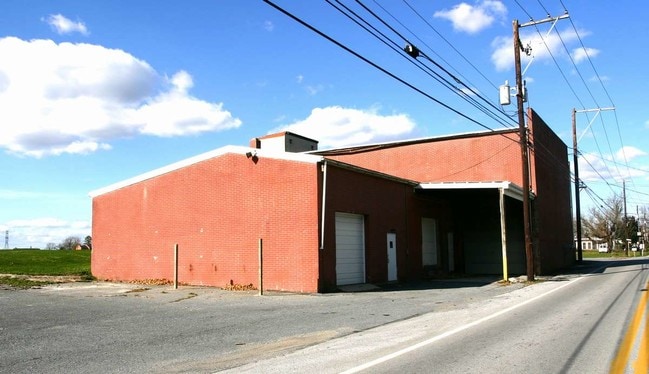
2166 Willow Street Pike, Lancaster, PA 17602

NEARBY LISTINGS FOR SALE OR LEASE
Property Detail
2166 Willow Street Pike
320-30225-0-0000
2166 WILLOW STREET PIKE
Servicestation
Lancaster
A
Pennsylvania
42071C0506F
1
2024
3.10 AC
2025
Lancaster County
013305
Philadelphia
8,628 SF
Lancaster, PA
DEMOGRAPHICS near 2166 Willow Street Pike
1 Mile
3 Mile
5 Mile
2024 Total Population
4,510
70,798
148,601
2029 Population
4,536
71,158
149,593
Pop Growth 2024-2029
+ 0.58%
+ 0.51%
+ 0.67%
Average Age
50
40
39
2024 Total Households
1,677
26,295
56,719
HH Growth 2024-2029
(0.06%)
+ 0.38%
+ 0.59%
Median Household Inc
$90,978
$64,911
$69,616
Avg Household Size
2.30
2.50
2.40
2024 Avg HH Vehicles
2.00
2.00
2.00
Median Home Value
$267,150
$203,086
$222,772
Median Year Built
1986
1964
1963
Nearby Places
Map Layers
Map Styles
 Street
 Aerial
- Restaurants
- Banks
- Shops
- Fitness
- Groceries
PUBLIC TRANSPORTATION
COMMUTER RAIL
Lancaster (Keystone Service - Amtrak, Pennsylvanian - Amtrak)
DRIVE
WALK
Distance
Lancaster (Keystone Service - Amtrak, Pennsylvanian - Amtrak)
11 min
4.1 mi
AIRPORT
Harrisburg International
DRIVE
WALK
Distance
Harrisburg International
51 min
35.9 mi
Freight Ports
Port of Wilmington, RI
DRIVE
WALK
Distance
Port of Wilmington, RI
87 min
62.1 mi
Nearby Properties
Address
Land Use
TOTAL SIZE
Lot Size
Zoning
Address
Land Use
TOTAL SIZE
Lot Size
Zoning
1,906,102 SF
136.98 AC
R3
Address
Land Use
TOTAL SIZE
Lot Size
Zoning
1,120,221 SF
8.40 AC
Address
Land Use
TOTAL SIZE
Lot Size
Zoning
2,008,418 SF
76.74 AC
Address
Land Use
TOTAL SIZE
Lot Size
Zoning
206,666 SF
1 AC
CB1
Address
Land Use
TOTAL SIZE
Lot Size
Zoning
269,860 SF
0.90 AC
CB1
Address
Land Use
TOTAL SIZE
Lot Size
Zoning
315,373 SF
4.73 AC
DF
Address
Land Use
TOTAL SIZE
Lot Size
Zoning
333,041 SF
159.39 AC
RV
Address
Land Use
TOTAL SIZE
Lot Size
Zoning
178,234 SF
0.78 AC
CB
Address
Land Use
TOTAL SIZE
Lot Size
Zoning
35,920 SF
35.68 AC
Address
Land Use
TOTAL SIZE
Lot Size
Zoning
234,386 SF
15.30 AC
MU
Address
Land Use
TOTAL SIZE
Lot Size
Zoning
87,502 SF
11.69 AC
MU
Address
Land Use
TOTAL SIZE
Lot Size
Zoning
216,206 SF
17.88 AC
Address
Land Use
TOTAL SIZE
Lot Size
Zoning
156,190 SF
26.53 AC
Address
Land Use
TOTAL SIZE
Lot Size
Zoning
98,798 SF
42.19 AC
Address
Land Use
TOTAL SIZE
Lot Size
Zoning
32.52 AC
R-2
Address
Land Use
TOTAL SIZE
Lot Size
Zoning
109,300 SF
18.63 AC
Address
Land Use
TOTAL SIZE
Lot Size
Zoning
172,568 SF
9.76 AC
R3
Address
Land Use
TOTAL SIZE
Lot Size
Zoning
152,451 SF
0.84 AC
CB1
Address
Land Use
TOTAL SIZE
Lot Size
Zoning
139,557 SF
0.76 AC
Address
Land Use
TOTAL SIZE
Lot Size
Zoning
136,104 SF
11.14 AC
Address
Land Use
TOTAL SIZE
Lot Size
Zoning
281,887 SF
19.29 AC
R-3
Address
Land Use
TOTAL SIZE
Lot Size
Zoning
244,922 SF
18.40 AC
MU
Address
Land Use
TOTAL SIZE
Lot Size
Zoning
175,971 SF
20.40 AC
Address
Land Use
TOTAL SIZE
Lot Size
Zoning
164,716 SF
0.47 AC
Address
Land Use
TOTAL SIZE
Lot Size
Zoning
146,813 SF
96.80 AC
A
Address
Land Use
TOTAL SIZE
Lot Size
Zoning
87,866 SF
5.10 AC
R-3
Address
Land Use
TOTAL SIZE
Lot Size
Zoning
134,167 SF
1.62 AC
MU
Address
Land Use
TOTAL SIZE
Lot Size
Zoning
278,244 SF
29.90 AC
R-3
Address
Land Use
TOTAL SIZE
Lot Size
Zoning
65,964 SF
12.80 AC
A
Address
Land Use
TOTAL SIZE
Lot Size
Zoning
95,432 SF
10.19 AC
The World's #1 Commercial Real Estate Marketplace
Connect with us
© 2026 CoStar Group
The information above has been obtained from sources believed reliable. While we do not doubt its accuracy we have not verified it and make no guarantee, warranty or representation about it. It is your responsibility to independently confirm its accuracy and completeness. Any projections, opinions, assumptions, or estimates used are for example only and do not represent the current or future performance of the property. The value of this transaction to you depends on tax and other factors which should be evaluated by your tax, financial, and legal advisors. You and your advisors should conduct a careful, independent investigation of the property to determine to your satisfaction the suitability of the property for your needs.