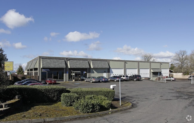
Property Record
21675 Sw Tualatin Valley Hwy, Beaverton, OR 97003

Save to a Folder
{{folder.Name}}
{{folder.ListingIds.length}} Properties
{{folder.ListingIds.length}} Property
Create a New Folder
Property Detail
21675 Sw Tualatin Valley Hwy
R0347725
LADD & REED ACRES, BLOCK 2, LOT PT 16, ACRES 0.73
Commercialbuilding
WASHINGTON
GC
Oregon
B and X Area of moderate flood hazard, usually the area between the limits of the 100-year and 500-year floods.
16
2024
0.73 AC
2026
Sunset Corridor/Hillsboro
031606
Portland
14,592 SF
Portland-Vancouver-Hillsboro, OR-WA
NEARBY LISTINGS FOR SALE OR LEASE
DEMOGRAPHICS near 21675 Sw Tualatin Valley Hwy
1 mile
3 mile
5 mile
2025 Total Population
15,597
141,475
285,350
2030 Population
16,153
143,537
288,548
Pop Growth 2025-2030
+ 3.56%
+ 1.46%
+ 1.12%
Average Age
39
38
39
2025 Total Households
5,396
53,142
108,154
HH Growth 2025-2030
+ 4.19%
+ 1.62%
+ 1.25%
Median Household Inc
$109,030
$103,727
$102,061
Avg Household Size
2.80
2.60
2.60
2025 Avg HH Vehicles
2.00
2.00
2.00
Median Home Value
$577,660
$519,068
$584,752
Median Year Built
1989
1996
1991
Nearby Places
Map Layers
Map Styles
 Street
 Aerial
Layers
 Traffic
 Biking
Places
Listings with unknown addresses are not visible on the map
- Restaurants
- Banks
- Shops
- Fitness
- Groceries
PUBLIC TRANSPORTATION
COMMUTER RAIL
Beaverton Transit Center (West Side Express) (Westside Express Service - Tri-County Metropolitan Transportation District of Oregon Rail (TriMet Rail))
Drive
Walk
Distance
Beaverton Transit Center (West Side Express) (Westside Express Service - Tri-County Metropolitan Transportation District of Oregon Rail (TriMet Rail))
12 min
5.3 mi
Hall/Nimbus (Westside Express Service - Tri-County Metropolitan Transportation District of Oregon Rail (TriMet Rail))
Drive
Walk
Distance
Hall/Nimbus (Westside Express Service - Tri-County Metropolitan Transportation District of Oregon Rail (TriMet Rail))
16 min
7.7 mi
AIRPORT
Portland International
Drive
Walk
Distance
Portland International
43 min
25.5 mi
Freight Ports
Port of Portland
Drive
Walk
Distance
Port of Portland
27 min
14.6 mi
SALE & LEASE HISTORY
LISTING DATE
SALE/LEASE

Dec 15, 2025
For Sale
Nearby Properties
Address
Land Use
TOTAL SIZE
Lot Size
Zoning
Address
Land Use
TOTAL SIZE
Lot Size
Zoning
373,884 SF
153.56 AC
UC-RP
Address
Land Use
TOTAL SIZE
Lot Size
Zoning
1,004,655 SF
24.55 AC
SCR-V
Address
Land Use
TOTAL SIZE
Lot Size
Zoning
60.97 AC
INST
Address
Land Use
TOTAL SIZE
Lot Size
Zoning
5.83 AC
INST
Address
Land Use
TOTAL SIZE
Lot Size
Zoning
37.66 AC
IND
Address
Land Use
TOTAL SIZE
Lot Size
Zoning
194.52 AC
R1
Address
Land Use
TOTAL SIZE
Lot Size
Zoning
256,652 SF
48.72 AC
SFR-7
Address
Land Use
TOTAL SIZE
Lot Size
Zoning
482,173 SF
14.99 AC
C-G
Address
Land Use
TOTAL SIZE
Lot Size
Zoning
260,677 SF
16.86 AC
INST
Address
Land Use
TOTAL SIZE
Lot Size
Zoning
281,695 SF
7.41 AC
SC-HDR
Address
Land Use
TOTAL SIZE
Lot Size
Zoning
152,339 SF
28.70 AC
R1
Address
Land Use
TOTAL SIZE
Lot Size
Zoning
270,000 SF
37.85 AC
SFR-6
Address
Land Use
TOTAL SIZE
Lot Size
Zoning
0.68 AC
SCR-V
Address
Land Use
TOTAL SIZE
Lot Size
Zoning
495,454 SF
16.99 AC
SCR-V
Address
Land Use
TOTAL SIZE
Lot Size
Zoning
8.12 AC
SFR-4.5
Address
Land Use
TOTAL SIZE
Lot Size
Zoning
18.15 AC
SC-E
Address
Land Use
TOTAL SIZE
Lot Size
Zoning
324,326 SF
4.23 AC
SCC-SC
Address
Land Use
TOTAL SIZE
Lot Size
Zoning
43,041 SF
9.43 AC
SFR-7
Address
Land Use
TOTAL SIZE
Lot Size
Zoning
373,552 SF
13.19 AC
MFR-3
Address
Land Use
TOTAL SIZE
Lot Size
Zoning
90,670 SF
12.17 AC
UC-MU
Address
Land Use
TOTAL SIZE
Lot Size
Zoning
15.14 AC
MFR-3
Address
Land Use
TOTAL SIZE
Lot Size
Zoning
21.97 AC
R1
Address
Land Use
TOTAL SIZE
Lot Size
Zoning
188,509 SF
17.27 AC
UC-OR
Address
Land Use
TOTAL SIZE
Lot Size
Zoning
6.03 AC
SCR-MD
Address
Land Use
TOTAL SIZE
Lot Size
Zoning
19.79 AC
R4
Address
Land Use
TOTAL SIZE
Lot Size
Zoning
87,200 SF
6.66 AC
INST
Address
Land Use
TOTAL SIZE
Lot Size
Zoning
5.57 AC
MU-VTC
Address
Land Use
TOTAL SIZE
Lot Size
Zoning
219,963 SF
7.41 AC
TO:R18-24
Address
Land Use
TOTAL SIZE
Lot Size
Zoning
133,942 SF
19.46 AC
INST
Address
Land Use
TOTAL SIZE
Lot Size
Zoning
12.31 AC
MFR-3
The World's #1 Commercial Real Estate Marketplace
Connect with us
© 2026 CoStar Group
The information above has been obtained from sources believed reliable. While we do not doubt its accuracy we have not verified it and make no guarantee, warranty or representation about it. It is your responsibility to independently confirm its accuracy and completeness. Any projections, opinions, assumptions, or estimates used are for example only and do not represent the current or future performance of the property. The value of this transaction to you depends on tax and other factors which should be evaluated by your tax, financial, and legal advisors. You and your advisors should conduct a careful, independent investigation of the property to determine to your satisfaction the suitability of the property for your needs.