Property Record
2168 Pegasus Pky, Lagrange, GA 30240


Property Detail
2168 Pegasus Pky
071-4-000-004
2168 PEGASUS PKWY / PB-76 PG-167
Governmentalpublicusegeneral
Troup
16- CP-GI
Georgia
B and X Area of moderate flood hazard, usually the area between the limits of the 100-year and 500-year floods.
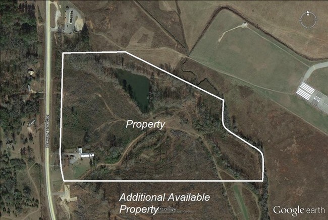
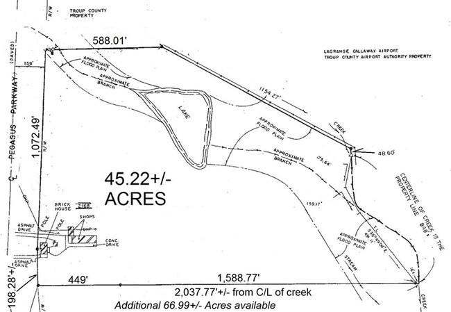
45.14 AC
0
Troup County
2025
Columbus GA
960904
LaGrange, GA-AL
4,180 SF
NEARBY LISTINGS FOR SALE OR LEASE
DEMOGRAPHICS near 2168 Pegasus Pky
1 mile
3 mile
5 mile
2025 Total Population
532
10,582
31,455
2030 Population
541
10,888
32,430
Pop Growth 2025-2030
+ 1.69%
+ 2.89%
+ 3.10%
Average Age
41
40
39
2025 Total Households
216
4,052
12,247
HH Growth 2025-2030
+ 1.85%
+ 3.06%
+ 3.32%
Median Household Inc
$73,234
$67,500
$55,760
Avg Household Size
2.40
2.50
2.50
2025 Avg HH Vehicles
2.00
2.00
2.00
Median Home Value
$371,874
$235,727
$224,007
Median Year Built
1995
1985
1980
Nearby Places
Map Layers
Map Styles
 Street
 Aerial
Layers
 Traffic
 Biking
Places
Listings with unknown addresses are not visible on the map
- Restaurants
- Banks
- Shops
- Fitness
- Groceries
SALE & LEASE HISTORY
LISTING DATE
SALE/LEASE

Sep 24, 2016
For Sale
Nearby Properties
Address
Land Use
TOTAL SIZE
Lot Size
Zoning
Address
Land Use
TOTAL SIZE
Lot Size
Zoning
497,181 SF
272.91 AC
16- CP-GI
Address
Land Use
TOTAL SIZE
Lot Size
Zoning
35,964 SF
72.39 AC
16- CP-GI
Address
Land Use
TOTAL SIZE
Lot Size
Zoning
17,328 SF
9.75 AC
16- CP-GB
Address
Land Use
TOTAL SIZE
Lot Size
Zoning
525,250 SF
45.33 AC
16- CP-GI
Address
Land Use
TOTAL SIZE
Lot Size
Zoning
35,269 SF
22.34 AC
16- CR-MR
Address
Land Use
TOTAL SIZE
Lot Size
Zoning
95,472 SF
30.05 AC
16- CR-MR
Address
Land Use
TOTAL SIZE
Lot Size
Zoning
4,909 SF
715.68 AC
16- CP-GI
Address
Land Use
TOTAL SIZE
Lot Size
Zoning
323,137 SF
34.65 AC
16- CP-GI
Address
Land Use
TOTAL SIZE
Lot Size
Zoning
757,316 SF
72.64 AC
16- CP-GI
Address
Land Use
TOTAL SIZE
Lot Size
Zoning
Address
Land Use
TOTAL SIZE
Lot Size
Zoning
343,734 SF
19.82 AC
16- CP-GI
Address
Land Use
TOTAL SIZE
Lot Size
Zoning
Address
Land Use
TOTAL SIZE
Lot Size
Zoning
484,700 SF
54.09 AC
16- CP-GI
Address
Land Use
TOTAL SIZE
Lot Size
Zoning
53,565 SF
26.06 AC
16- CP-GI
Address
Land Use
TOTAL SIZE
Lot Size
Zoning
27,080 SF
27.40 AC
16- CP-GB
Address
Land Use
TOTAL SIZE
Lot Size
Zoning
26,595 SF
20.13 AC
16- CR-MX
Address
Land Use
TOTAL SIZE
Lot Size
Zoning
151,088 SF
7.10 AC
16- CP-GI
Address
Land Use
TOTAL SIZE
Lot Size
Zoning
7,380 SF
126.31 AC
16- CP-GI
Address
Land Use
TOTAL SIZE
Lot Size
Zoning
Address
Land Use
TOTAL SIZE
Lot Size
Zoning
89,395 SF
28.47 AC
16- TN-R
Address
Land Use
TOTAL SIZE
Lot Size
Zoning
9,290 SF
11.58 AC
16- CP-GB
Address
Land Use
TOTAL SIZE
Lot Size
Zoning
692,158 SF
147.20 AC
16- CP-GI
Address
Land Use
TOTAL SIZE
Lot Size
Zoning
209,312 SF
26.56 AC
16- CP-GI
Address
Land Use
TOTAL SIZE
Lot Size
Zoning
56,580 SF
11.34 AC
16- CR-MX
Address
Land Use
TOTAL SIZE
Lot Size
Zoning
97,903 SF
4.50 AC
16- CP-GI
Address
Land Use
TOTAL SIZE
Lot Size
Zoning
1 AC
16-UNAVAIL
Address
Land Use
TOTAL SIZE
Lot Size
Zoning
57,971 SF
7.98 AC
16- CP-GB
Address
Land Use
TOTAL SIZE
Lot Size
Zoning
Address
Land Use
TOTAL SIZE
Lot Size
Zoning
91,254 SF
1.48 AC
16- CP-GB
Address
Land Use
TOTAL SIZE
Lot Size
Zoning
64,432 SF
81.09 AC
16- CP-GB
The World's #1 Commercial Real Estate Marketplace
Connect with us
© 2026 CoStar Group
The information above has been obtained from sources believed reliable. While we do not doubt its accuracy we have not verified it and make no guarantee, warranty or representation about it. It is your responsibility to independently confirm its accuracy and completeness. Any projections, opinions, assumptions, or estimates used are for example only and do not represent the current or future performance of the property. The value of this transaction to you depends on tax and other factors which should be evaluated by your tax, financial, and legal advisors. You and your advisors should conduct a careful, independent investigation of the property to determine to your satisfaction the suitability of the property for your needs.