Property Record
Pegasus Pkwy, Lagrange, GA 30240
NEARBY LISTINGS FOR SALE OR LEASE
Property Detail
Pegasus Pkwy
LaGrange, GA-AL
Rural Land Conversion - Comm
071-4-000-005
PEGASUS PKWY /LL 25,27 OF 5TH/ PB-76 PG-230
Industrialacreage
Troup
A
Georgia
13285C0139E
26
2024
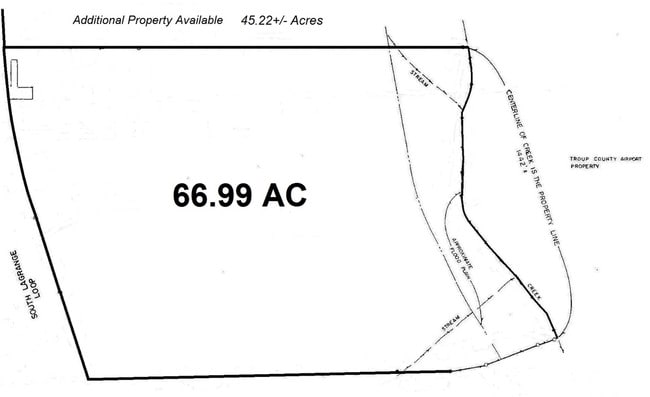
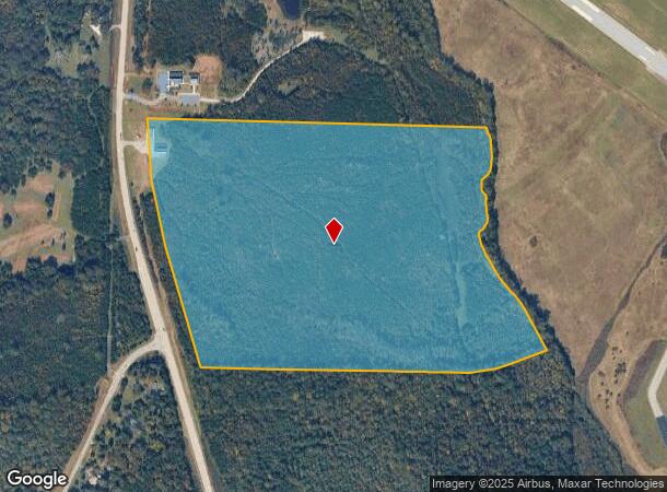
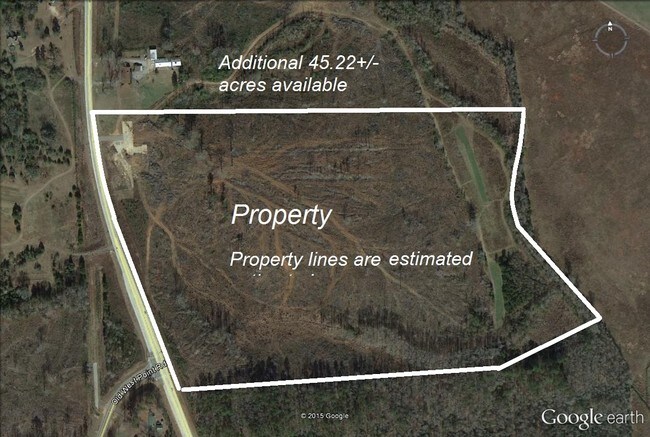
66.99 AC
2025
Troup County
960300
Columbus GA
DEMOGRAPHICS near Pegasus Pkwy
1 mile
3 mile
5 mile
2024 Total Population
327
10,090
31,429
2029 Population
326
10,230
31,916
Pop Growth 2024-2029
(0.31%)
+ 1.39%
+ 1.55%
Average Age
41
39
39
2024 Total Households
129
3,853
12,197
HH Growth 2024-2029
0.00%
+ 1.38%
+ 1.58%
Median Household Inc
$49,731
$48,894
$47,046
Avg Household Size
2.50
2.50
2.50
2024 Avg HH Vehicles
2.00
2.00
2.00
Median Home Value
$361,764
$184,545
$171,090
Median Year Built
1996
1983
1979
Nearby Places
Map Layers
Map Styles
 Street
 Aerial
Transit
 Traffic
 Biking
Places
Listings with unknown addresses are not visible on the map
- Restaurants
- Banks
- Shops
- Fitness
- Groceries
SALE & LEASE HISTORY
LISTING DATE
SALE/LEASE

Sep 24, 2016
For Sale
Apr 27, 2018
For Sale
Nearby Properties
Address
Land Use
TOTAL SIZE
Lot Size
Zoning
Address
Land Use
TOTAL SIZE
Lot Size
Zoning
35,964 SF
72.39 AC
16- CP-GI
Address
Land Use
TOTAL SIZE
Lot Size
Zoning
334,378 SF
267.59 AC
16- CP-GI
Address
Land Use
TOTAL SIZE
Lot Size
Zoning
525,250 SF
45.33 AC
16- CP-GI
Address
Land Use
TOTAL SIZE
Lot Size
Zoning
17,328 SF
10.66 AC
16- CP-GB
Address
Land Use
TOTAL SIZE
Lot Size
Zoning
35,269 SF
22.34 AC
16- CR-MR
Address
Land Use
TOTAL SIZE
Lot Size
Zoning
95,472 SF
30.05 AC
16- CR-MR
Address
Land Use
TOTAL SIZE
Lot Size
Zoning
4,909 SF
731.14 AC
16- CP-GI
Address
Land Use
TOTAL SIZE
Lot Size
Zoning
323,137 SF
34.65 AC
16- CP-GI
Address
Land Use
TOTAL SIZE
Lot Size
Zoning
162,803 SF
3.71 AC
16- CP-GI
Address
Land Use
TOTAL SIZE
Lot Size
Zoning
30,224 SF
19.82 AC
16- CP-GI
Address
Land Use
TOTAL SIZE
Lot Size
Zoning
551,306 SF
72.64 AC
16- CP-GI
Address
Land Use
TOTAL SIZE
Lot Size
Zoning
484,700 SF
54.09 AC
16- CP-GI
Address
Land Use
TOTAL SIZE
Lot Size
Zoning
53,565 SF
26.06 AC
16- CP-GI
Address
Land Use
TOTAL SIZE
Lot Size
Zoning
27,080 SF
27.40 AC
16- CP-GB
Address
Land Use
TOTAL SIZE
Lot Size
Zoning
26,595 SF
20.13 AC
16- CR-MX
Address
Land Use
TOTAL SIZE
Lot Size
Zoning
151,088 SF
7.10 AC
16- CP-GI
Address
Land Use
TOTAL SIZE
Lot Size
Zoning
7,380 SF
126.31 AC
16- CP-GI
Address
Land Use
TOTAL SIZE
Lot Size
Zoning
89,395 SF
28.47 AC
16- TN-R
Address
Land Use
TOTAL SIZE
Lot Size
Zoning
9,290 SF
11.58 AC
16- CP-GB
Address
Land Use
TOTAL SIZE
Lot Size
Zoning
24,412 SF
147.20 AC
16- CP-GI
Address
Land Use
TOTAL SIZE
Lot Size
Zoning
209,312 SF
26.56 AC
16- CP-GI
Address
Land Use
TOTAL SIZE
Lot Size
Zoning
56,580 SF
12.87 AC
16- CR-MX
Address
Land Use
TOTAL SIZE
Lot Size
Zoning
97,903 SF
4.50 AC
16- CP-GI
Address
Land Use
TOTAL SIZE
Lot Size
Zoning
1 AC
16-UNAVAIL
Address
Land Use
TOTAL SIZE
Lot Size
Zoning
2,513 SF
14.10 AC
16- TN-MX
Address
Land Use
TOTAL SIZE
Lot Size
Zoning
57,971 SF
7.98 AC
16- CP-GB
Address
Land Use
TOTAL SIZE
Lot Size
Zoning
64,432 SF
81.09 AC
16- CP-GB
Address
Land Use
TOTAL SIZE
Lot Size
Zoning
80,979 SF
15 AC
16- CP-GI
Address
Land Use
TOTAL SIZE
Lot Size
Zoning
42,528 SF
26.81 AC
16- CP-GB
Address
Land Use
TOTAL SIZE
Lot Size
Zoning
11,342 SF
31.82 AC
16- CP-GI
The World's #1 Commercial Real Estate Marketplace
Connect with us
© 2026 CoStar Group
The information above has been obtained from sources believed reliable. While we do not doubt its accuracy we have not verified it and make no guarantee, warranty or representation about it. It is your responsibility to independently confirm its accuracy and completeness. Any projections, opinions, assumptions, or estimates used are for example only and do not represent the current or future performance of the property. The value of this transaction to you depends on tax and other factors which should be evaluated by your tax, financial, and legal advisors. You and your advisors should conduct a careful, independent investigation of the property to determine to your satisfaction the suitability of the property for your needs.