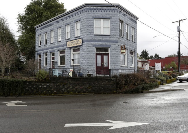
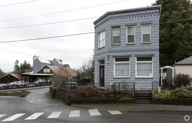
Property Record
21690 Main St Ne, Aurora, OR 97002


Save to a Folder
{{folder.Name}}
{{folder.ListingIds.length}} Properties
{{folder.ListingIds.length}} Property
Create a New Folder
Property Detail
21690 Main St Ne
597901
AURORA ORIGINAL BLOCK 4 LOT FR 3 ACRES .05
Officebuilding
Marion
C
Oregon
B and X Area of moderate flood hazard, usually the area between the limits of the 100-year and 500-year floods.
3
2024
0.05 AC
2025
Marion County
010202
Portland
2,996 SF
Salem, OR
NEARBY LISTINGS FOR SALE OR LEASE
-
-
View all Aurora listings for sale on LoopNet.com
DEMOGRAPHICS near 21690 Main St Ne
1 mile
3 mile
5 mile
2025 Total Population
1,608
4,849
40,455
2030 Population
1,617
4,846
40,762
Pop Growth 2025-2030
+ 0.56%
(0.06%)
+ 0.76%
Average Age
40
43
43
2025 Total Households
569
1,762
15,217
HH Growth 2025-2030
+ 0.53%
+ 0.06%
+ 0.78%
Median Household Inc
$70,356
$65,867
$93,961
Avg Household Size
2.80
2.70
2.60
2025 Avg HH Vehicles
2.00
2.00
2.00
Median Home Value
$453,787
$469,688
$557,457
Median Year Built
1984
1981
1987
Nearby Places
Map Layers
Map Styles
 Street
 Aerial
Layers
 Traffic
 Biking
Places
Listings with unknown addresses are not visible on the map
- Restaurants
- Banks
- Shops
- Fitness
- Groceries
PUBLIC TRANSPORTATION
COMMUTER RAIL
Wilsonville (Westside Express Service - Tri-County Metropolitan Transportation District of Oregon Rail (TriMet Rail))
Drive
Walk
Distance
Wilsonville (Westside Express Service - Tri-County Metropolitan Transportation District of Oregon Rail (TriMet Rail))
14 min
6.7 mi
AIRPORT
Portland International
Drive
Walk
Distance
Portland International
49 min
31.3 mi
Nearby Properties
Address
Land Use
TOTAL SIZE
Lot Size
Zoning
Address
Land Use
TOTAL SIZE
Lot Size
Zoning
165,375 SF
27.47 AC
P-LU
Address
Land Use
TOTAL SIZE
Lot Size
Zoning
Address
Land Use
TOTAL SIZE
Lot Size
Zoning
19.24 AC
P
Address
Land Use
TOTAL SIZE
Lot Size
Zoning
13.91 AC
M1
Address
Land Use
TOTAL SIZE
Lot Size
Zoning
4.53 AC
P
Address
Land Use
TOTAL SIZE
Lot Size
Zoning
Address
Land Use
TOTAL SIZE
Lot Size
Zoning
42,972 SF
0.99 AC
P
Address
Land Use
TOTAL SIZE
Lot Size
Zoning
24,734 SF
10.58 AC
ID
Address
Land Use
TOTAL SIZE
Lot Size
Zoning
Address
Land Use
TOTAL SIZE
Lot Size
Zoning
20 SF
0.73 AC
P
Address
Land Use
TOTAL SIZE
Lot Size
Zoning
24,905 SF
19.98 AC
ID
Address
Land Use
TOTAL SIZE
Lot Size
Zoning
20 SF
0.48 AC
P
Address
Land Use
TOTAL SIZE
Lot Size
Zoning
36,810 SF
0.78 AC
P
Address
Land Use
TOTAL SIZE
Lot Size
Zoning
42,400 SF
9.71 AC
ID
Address
Land Use
TOTAL SIZE
Lot Size
Zoning
39,666 SF
8.39 AC
I
Address
Land Use
TOTAL SIZE
Lot Size
Zoning
30,612 SF
0.71 AC
P
Address
Land Use
TOTAL SIZE
Lot Size
Zoning
171.47 AC
EFU
Address
Land Use
TOTAL SIZE
Lot Size
Zoning
6.82 AC
CM
Address
Land Use
TOTAL SIZE
Lot Size
Zoning
26,010 SF
0.60 AC
P
Address
Land Use
TOTAL SIZE
Lot Size
Zoning
41,050 SF
23.98 AC
EFU
Address
Land Use
TOTAL SIZE
Lot Size
Zoning
Address
Land Use
TOTAL SIZE
Lot Size
Zoning
0.67 AC
CM
Address
Land Use
TOTAL SIZE
Lot Size
Zoning
Address
Land Use
TOTAL SIZE
Lot Size
Zoning
Address
Land Use
TOTAL SIZE
Lot Size
Zoning
Address
Land Use
TOTAL SIZE
Lot Size
Zoning
Address
Land Use
TOTAL SIZE
Lot Size
Zoning
22,630 SF
0.53 AC
P
Address
Land Use
TOTAL SIZE
Lot Size
Zoning
68,760 SF
9.86 AC
P
Address
Land Use
TOTAL SIZE
Lot Size
Zoning
21,280 SF
0.52 AC
Address
Land Use
TOTAL SIZE
Lot Size
Zoning
1.82 AC
C
The World's #1 Commercial Real Estate Marketplace
Connect with us
© 2026 CoStar Group
The information above has been obtained from sources believed reliable. While we do not doubt its accuracy we have not verified it and make no guarantee, warranty or representation about it. It is your responsibility to independently confirm its accuracy and completeness. Any projections, opinions, assumptions, or estimates used are for example only and do not represent the current or future performance of the property. The value of this transaction to you depends on tax and other factors which should be evaluated by your tax, financial, and legal advisors. You and your advisors should conduct a careful, independent investigation of the property to determine to your satisfaction the suitability of the property for your needs.