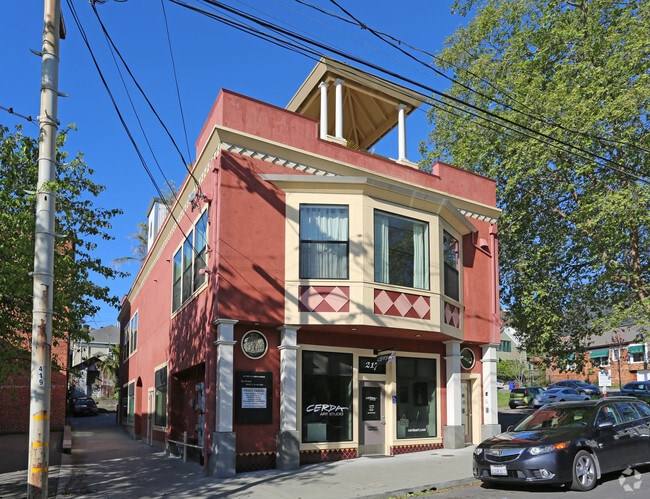
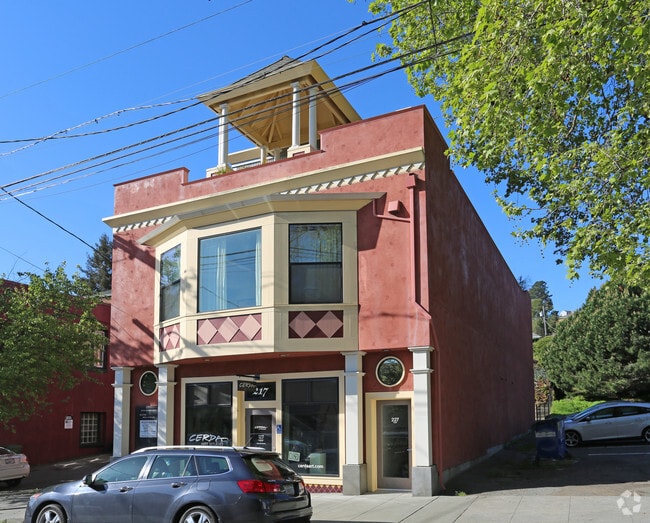
Property Record
243 W Richmond Ave, Richmond, CA 94801
Current Lease Availabilities
NEARBY LISTINGS FOR SALE OR LEASE
Property Detail
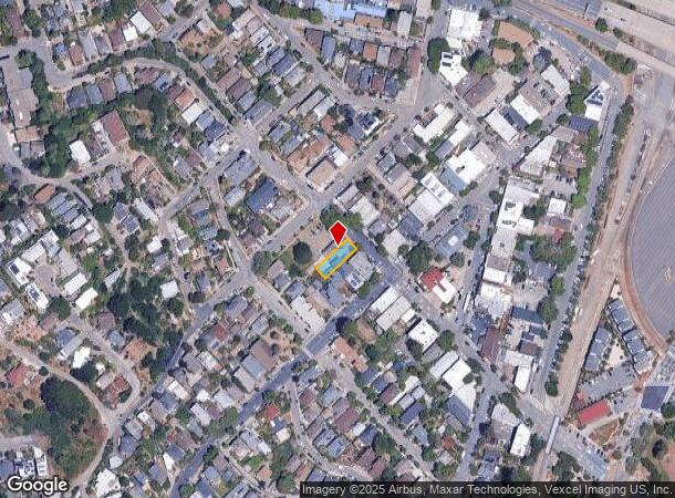
243 W Richmond Ave
Oakland-Hayward-Berkeley, CA
Richmond Map 01
558-164-002-5
TOWN OF RICHMOND #1 3 3
Storebuilding
Contra Costa
X
California
06041C0495E
3
2024
0.11 AC
2025
Richmond/San Pablo
376000
East Bay/Oakland
4,455 SF
DEMOGRAPHICS near 243 W Richmond Ave
1 Mile
3 Mile
5 Mile
2024 Total Population
3,717
71,013
163,938
2029 Population
3,677
70,475
162,415
Pop Growth 2024-2029
(1.08%)
(0.76%)
(0.93%)
Average Age
46
37
39
2024 Total Households
1,743
21,868
54,260
HH Growth 2024-2029
(1.03%)
(0.77%)
(0.98%)
Median Household Inc
$114,224
$73,061
$80,979
Avg Household Size
2.10
3.10
2.90
2024 Avg HH Vehicles
2.00
2.00
2.00
Median Home Value
$986,978
$621,812
$710,103
Median Year Built
1962
1961
1961
Nearby Places
- Restaurants
- Banks
- Shops
- Fitness
- Groceries
PUBLIC TRANSPORTATION
COMMUTER RAIL
Richmond (Capitol Corridor - Capitol Corridor Joint Powers Authority)
DRIVE
WALK
Distance
Richmond (Capitol Corridor - Capitol Corridor Joint Powers Authority)
5 min
2.6 mi
Berkeley (Capitol Corridor - Amtrak)
DRIVE
WALK
Distance
Berkeley (Capitol Corridor - Amtrak)
12 min
8.2 mi
AIRPORT
Metro Oakland International
DRIVE
WALK
Distance
Metro Oakland International
31 min
22.6 mi
San Francisco International
DRIVE
WALK
Distance
San Francisco International
43 min
30.2 mi
Freight Ports
Port of Richmond
DRIVE
WALK
Distance
Port of Richmond
7 min
3.1 mi
Nearby Properties
Address
Land Use
TOTAL SIZE
Lot Size
Zoning
Address
Land Use
TOTAL SIZE
Lot Size
Zoning
244.30 AC
Address
Land Use
TOTAL SIZE
Lot Size
Zoning
55.76 AC
Address
Land Use
TOTAL SIZE
Lot Size
Zoning
269.14 AC
Address
Land Use
TOTAL SIZE
Lot Size
Zoning
38.33 AC
Address
Land Use
TOTAL SIZE
Lot Size
Zoning
820,000 SF
6.36 AC
Address
Land Use
TOTAL SIZE
Lot Size
Zoning
68,400 SF
5.13 AC
CM
Address
Land Use
TOTAL SIZE
Lot Size
Zoning
76.15 AC
Address
Land Use
TOTAL SIZE
Lot Size
Zoning
481,487 SF
27.88 AC
P-1
Address
Land Use
TOTAL SIZE
Lot Size
Zoning
476,200 SF
22.92 AC
Address
Land Use
TOTAL SIZE
Lot Size
Zoning
581,157 SF
10.52 AC
Address
Land Use
TOTAL SIZE
Lot Size
Zoning
195,281 SF
0.96 AC
Address
Land Use
TOTAL SIZE
Lot Size
Zoning
139,846 SF
0.76 AC
Address
Land Use
TOTAL SIZE
Lot Size
Zoning
3,950 SF
11.47 AC
Address
Land Use
TOTAL SIZE
Lot Size
Zoning
19,308 SF
40.39 AC
Address
Land Use
TOTAL SIZE
Lot Size
Zoning
105,704 SF
10.85 AC
M3
Address
Land Use
TOTAL SIZE
Lot Size
Zoning
35.94 AC
Address
Land Use
TOTAL SIZE
Lot Size
Zoning
22.06 AC
Address
Land Use
TOTAL SIZE
Lot Size
Zoning
16,800 SF
11.62 AC
Address
Land Use
TOTAL SIZE
Lot Size
Zoning
4,550 SF
24.81 AC
Address
Land Use
TOTAL SIZE
Lot Size
Zoning
245,894 SF
12.67 AC
M2
Address
Land Use
TOTAL SIZE
Lot Size
Zoning
202,811 SF
10.98 AC
Address
Land Use
TOTAL SIZE
Lot Size
Zoning
149,502 SF
7.94 AC
Address
Land Use
TOTAL SIZE
Lot Size
Zoning
69,949 SF
0.65 AC
C2 CD
Address
Land Use
TOTAL SIZE
Lot Size
Zoning
182,408 SF
10.55 AC
Address
Land Use
TOTAL SIZE
Lot Size
Zoning
34.95 AC
M3
Address
Land Use
TOTAL SIZE
Lot Size
Zoning
96,440 SF
4.73 AC
Address
Land Use
TOTAL SIZE
Lot Size
Zoning
404,098 SF
24.03 AC
MSL1RD
Address
Land Use
TOTAL SIZE
Lot Size
Zoning
131,400 SF
8.93 AC
M-1
Address
Land Use
TOTAL SIZE
Lot Size
Zoning
256.13 AC
Address
Land Use
TOTAL SIZE
Lot Size
Zoning
14.93 AC
The World's #1 Commercial Real Estate Marketplace
Connect with us
© 2025 CoStar Group
The information above has been obtained from sources believed reliable. While we do not doubt its accuracy we have not verified it and make no guarantee, warranty or representation about it. It is your responsibility to independently confirm its accuracy and completeness. Any projections, opinions, assumptions, or estimates used are for example only and do not represent the current or future performance of the property. The value of this transaction to you depends on tax and other factors which should be evaluated by your tax, financial, and legal advisors. You and your advisors should conduct a careful, independent investigation of the property to determine to your satisfaction the suitability of the property for your needs.