Property Record
217 Hillard Dr, Murfreesboro, TN 37129
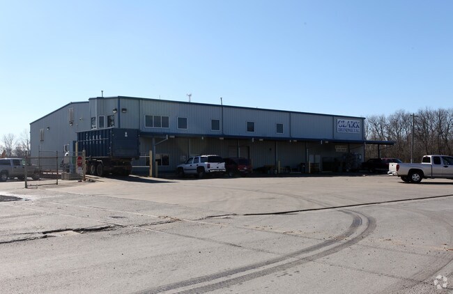

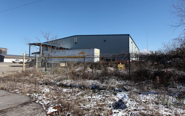
Property Detail
217 Hillard Dr
Nashville-Davidson--Murfreesboro--Franklin, TN
LOT 19A MBORO HOUSING AUTHORITY BROAD ST DEV PB29-229
102C-E-001.03-000
Rutherford
Warehouse
Tennessee
AE The base floodplain where base flood elevations are provided. AE Zones are now used on new format FIRMs instead of A1-A30 Zones.
19a
2025
6.15 AC
2025
Southeast
041800
Nashville
24,750 SF
NEARBY LISTINGS FOR SALE OR LEASE
DEMOGRAPHICS near 217 Hillard Dr
1 mile
3 mile
5 mile
2025 Total Population
9,020
75,947
167,297
2030 Population
9,810
81,734
180,669
Pop Growth 2025-2030
+ 8.76%
+ 7.62%
+ 7.99%
Average Age
37
35
36
2025 Total Households
3,746
30,825
65,356
HH Growth 2025-2030
+ 9.34%
+ 7.96%
+ 8.20%
Median Household Inc
$53,110
$57,538
$75,064
Avg Household Size
2.10
2.30
2.50
2025 Avg HH Vehicles
2.00
2.00
2.00
Median Home Value
$399,127
$372,532
$411,559
Median Year Built
1975
1990
1998
Nearby Places
Map Layers
Map Styles
 Street
 Aerial
Transit
 Traffic
 Biking
Places
Listings with unknown addresses are not visible on the map
- Restaurants
- Banks
- Shops
- Fitness
- Groceries
PUBLIC TRANSPORTATION
AIRPORT
Nashville International
Drive
Walk
Distance
Nashville International
37 min
29.3 mi
Freight Ports
Port of Mobile
Drive
Walk
Distance
Port of Mobile
492 min
450.4 mi
Nearby Properties
Address
Land Use
TOTAL SIZE
Lot Size
Zoning
Address
Land Use
TOTAL SIZE
Lot Size
Zoning
969,473 SF
43.50 AC
Address
Land Use
TOTAL SIZE
Lot Size
Zoning
30,630 SF
8.50 AC
Address
Land Use
TOTAL SIZE
Lot Size
Zoning
166,604 SF
2.21 AC
Address
Land Use
TOTAL SIZE
Lot Size
Zoning
104,174 SF
11.06 AC
Address
Land Use
TOTAL SIZE
Lot Size
Zoning
12,391 SF
20.36 AC
Address
Land Use
TOTAL SIZE
Lot Size
Zoning
295,095 SF
80 AC
Address
Land Use
TOTAL SIZE
Lot Size
Zoning
5,260 SF
21.91 AC
Address
Land Use
TOTAL SIZE
Lot Size
Zoning
231,649 SF
19.95 AC
Address
Land Use
TOTAL SIZE
Lot Size
Zoning
17,330 SF
10.20 AC
Address
Land Use
TOTAL SIZE
Lot Size
Zoning
10,760 SF
19.48 AC
Address
Land Use
TOTAL SIZE
Lot Size
Zoning
408,067 SF
33.01 AC
CH
Address
Land Use
TOTAL SIZE
Lot Size
Zoning
13,818 SF
7.43 AC
Address
Land Use
TOTAL SIZE
Lot Size
Zoning
146,555 SF
3.22 AC
Address
Land Use
TOTAL SIZE
Lot Size
Zoning
2,472 SF
44.34 AC
Address
Land Use
TOTAL SIZE
Lot Size
Zoning
12,794 SF
20.44 AC
RM16
Address
Land Use
TOTAL SIZE
Lot Size
Zoning
160,540 SF
20.19 AC
Address
Land Use
TOTAL SIZE
Lot Size
Zoning
120,225 SF
20.40 AC
Address
Land Use
TOTAL SIZE
Lot Size
Zoning
102,366 SF
7.90 AC
Address
Land Use
TOTAL SIZE
Lot Size
Zoning
4,842 SF
17.80 AC
Address
Land Use
TOTAL SIZE
Lot Size
Zoning
113,271 SF
27.70 AC
Address
Land Use
TOTAL SIZE
Lot Size
Zoning
1,488 SF
17.26 AC
RM16
Address
Land Use
TOTAL SIZE
Lot Size
Zoning
106,006 SF
17.20 AC
Address
Land Use
TOTAL SIZE
Lot Size
Zoning
4,409 SF
21.60 AC
RM16
Address
Land Use
TOTAL SIZE
Lot Size
Zoning
78,768 SF
1.50 AC
Address
Land Use
TOTAL SIZE
Lot Size
Zoning
3,104 SF
16.01 AC
RM16
Address
Land Use
TOTAL SIZE
Lot Size
Zoning
403,206 SF
63.11 AC
Address
Land Use
TOTAL SIZE
Lot Size
Zoning
120,638 SF
20.55 AC
Address
Land Use
TOTAL SIZE
Lot Size
Zoning
6,253 SF
38.80 AC
RM16
Address
Land Use
TOTAL SIZE
Lot Size
Zoning
57,146 SF
3.47 AC
Address
Land Use
TOTAL SIZE
Lot Size
Zoning
123,688 SF
15.27 AC
The World's #1 Commercial Real Estate Marketplace
Connect with us
© 2026 CoStar Group
The information above has been obtained from sources believed reliable. While we do not doubt its accuracy we have not verified it and make no guarantee, warranty or representation about it. It is your responsibility to independently confirm its accuracy and completeness. Any projections, opinions, assumptions, or estimates used are for example only and do not represent the current or future performance of the property. The value of this transaction to you depends on tax and other factors which should be evaluated by your tax, financial, and legal advisors. You and your advisors should conduct a careful, independent investigation of the property to determine to your satisfaction the suitability of the property for your needs.