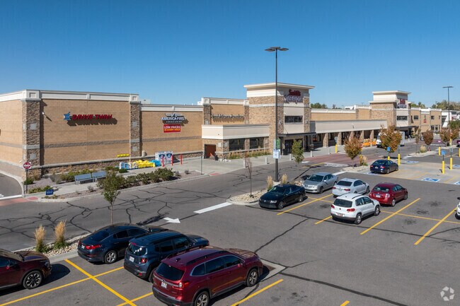
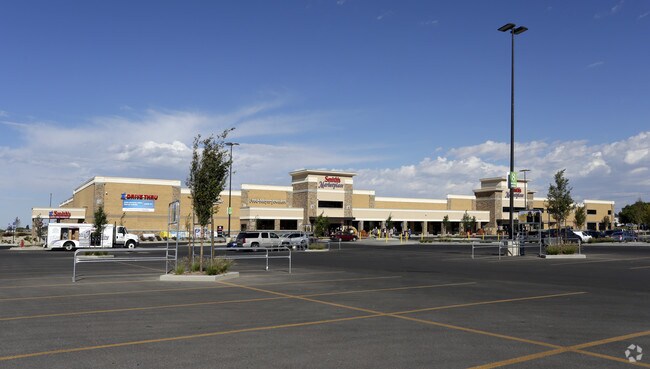
Property Record
217 N 2000 W, Clearfield, UT 84015


Save to a Folder
{{folder.Name}}
{{folder.ListingIds.length}} Properties
{{folder.ListingIds.length}} Property
Create a New Folder
Property Detail
217 N 2000 W
12-831-0013
ALL OF LOT 1, POINT, THE. CONT. 12.21800 ACRES LESS & EXCEPT THAT PPTY CONV IN SPECIAL WARRANTY DEED RECORDED 01/25/2022 AS E# 3452263 BK 7932 PG 1096 DESC AS FOLLOWS: PART OF LOT 1, POINT, THE
Supermarket
DAVIS
CC
Utah
B and X Area of moderate flood hazard, usually the area between the limits of the 100-year and 500-year floods.
1
2025
11.74 AC
2025
Davis/Weber Counties
125407
Salt Lake City
121,173 SF
Ogden, UT
NEARBY LISTINGS FOR SALE OR LEASE
DEMOGRAPHICS near 217 N 2000 W
1 mile
3 mile
5 mile
2025 Total Population
9,726
90,851
186,834
2030 Population
10,086
94,111
195,070
Pop Growth 2025-2030
+ 3.70%
+ 3.59%
+ 4.41%
Average Age
35
35
34
2025 Total Households
2,838
26,650
57,296
HH Growth 2025-2030
+ 3.81%
+ 3.76%
+ 4.56%
Median Household Inc
$105,812
$111,062
$102,079
Avg Household Size
3.40
3.40
3.20
2025 Avg HH Vehicles
3.00
3.00
2.00
Median Home Value
$472,162
$475,029
$459,124
Median Year Built
1994
1997
1997
Nearby Places
Map Layers
Map Styles
 Street
 Aerial
Layers
 Traffic
 Biking
Places
Listings with unknown addresses are not visible on the map
- Restaurants
- Banks
- Shops
- Fitness
- Groceries
PUBLIC TRANSPORTATION
COMMUTER RAIL
Clearfield Station (FrontRunner - Utah Transit Authority (UTA))
Drive
Walk
Distance
Clearfield Station (FrontRunner - Utah Transit Authority (UTA))
9 min
4.5 mi
Roy Station (FrontRunner - Utah Transit Authority (UTA))
Drive
Walk
Distance
Roy Station (FrontRunner - Utah Transit Authority (UTA))
12 min
6.5 mi
AIRPORT
Salt Lake City International
Drive
Walk
Distance
Salt Lake City International
42 min
33.6 mi
Freight Ports
Port of Stockton
Drive
Walk
Distance
Port of Stockton
742 min
724.0 mi
SALE & LEASE HISTORY
LISTING DATE
SALE/LEASE

Jun 03, 2020
For Sale
Nearby Properties
Address
Land Use
TOTAL SIZE
Lot Size
Zoning
Address
Land Use
TOTAL SIZE
Lot Size
Zoning
399,630 SF
31.55 AC
I
Address
Land Use
TOTAL SIZE
Lot Size
Zoning
664,440 SF
37.07 AC
Address
Land Use
TOTAL SIZE
Lot Size
Zoning
151,064 SF
48.81 AC
Address
Land Use
TOTAL SIZE
Lot Size
Zoning
86,213 SF
12.27 AC
Address
Land Use
TOTAL SIZE
Lot Size
Zoning
123,824 SF
41.89 AC
M1
Address
Land Use
TOTAL SIZE
Lot Size
Zoning
125,164 SF
7.12 AC
Address
Land Use
TOTAL SIZE
Lot Size
Zoning
121,332 SF
44.40 AC
Address
Land Use
TOTAL SIZE
Lot Size
Zoning
123,445 SF
27.94 AC
M1
Address
Land Use
TOTAL SIZE
Lot Size
Zoning
27,763 SF
11.41 AC
Address
Land Use
TOTAL SIZE
Lot Size
Zoning
638,065 SF
33.77 AC
M1
Address
Land Use
TOTAL SIZE
Lot Size
Zoning
91,750 SF
6.76 AC
C2
Address
Land Use
TOTAL SIZE
Lot Size
Zoning
63,828 SF
5.30 AC
PF
Address
Land Use
TOTAL SIZE
Lot Size
Zoning
1,540 SF
11.52 AC
Address
Land Use
TOTAL SIZE
Lot Size
Zoning
76,778 SF
5.51 AC
Address
Land Use
TOTAL SIZE
Lot Size
Zoning
5,481 SF
15.54 AC
Address
Land Use
TOTAL SIZE
Lot Size
Zoning
74,995 SF
6.07 AC
Address
Land Use
TOTAL SIZE
Lot Size
Zoning
223,079 SF
22.55 AC
Address
Land Use
TOTAL SIZE
Lot Size
Zoning
503,599 SF
47.71 AC
M1
Address
Land Use
TOTAL SIZE
Lot Size
Zoning
199,214 SF
19.59 AC
C1
Address
Land Use
TOTAL SIZE
Lot Size
Zoning
57,165 SF
8.50 AC
GC
Address
Land Use
TOTAL SIZE
Lot Size
Zoning
147,184 SF
2.53 AC
Address
Land Use
TOTAL SIZE
Lot Size
Zoning
46,207 SF
6.09 AC
A1
Address
Land Use
TOTAL SIZE
Lot Size
Zoning
293,860 SF
20.61 AC
M1
The World's #1 Commercial Real Estate Marketplace
Connect with us
© 2026 CoStar Group
The information above has been obtained from sources believed reliable. While we do not doubt its accuracy we have not verified it and make no guarantee, warranty or representation about it. It is your responsibility to independently confirm its accuracy and completeness. Any projections, opinions, assumptions, or estimates used are for example only and do not represent the current or future performance of the property. The value of this transaction to you depends on tax and other factors which should be evaluated by your tax, financial, and legal advisors. You and your advisors should conduct a careful, independent investigation of the property to determine to your satisfaction the suitability of the property for your needs.