Property Record
400 Highway 90 Way, Sugar Land, TX 77479
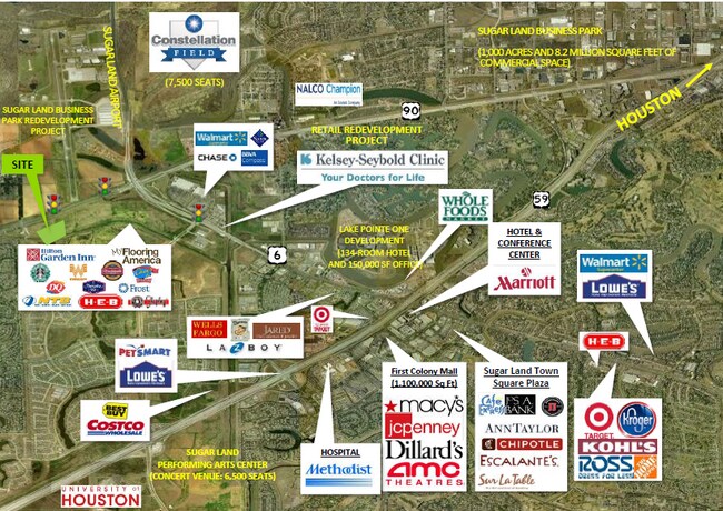
NEARBY LISTINGS FOR SALE OR LEASE
Property Detail
400 Highway 90 Way
Houston-The Woodlands-Sugar Land, TX
A Hodge
0032-00-000-0356-907
0032 A HODGE, BLOCK 1, ACRES 3.594, CROSSING AT TELFAIR SEC 4 PART TWO REPLAT AND EXTENSION OF RESERVE L, RESERVE I-4
Commercialacreage
Fort Bend
X
Texas
48157C0260L
3.59 AC
2024
E Fort Bend Co/Sugar Land
2025
Houston
674200
DEMOGRAPHICS near 400 Highway 90 Way
1 Mile
3 Mile
5 Mile
2024 Total Population
5,152
81,807
236,612
2029 Population
6,154
97,703
281,113
Pop Growth 2024-2029
+ 19.45%
+ 19.43%
+ 18.81%
Average Age
41
40
40
2024 Total Households
1,772
27,959
78,010
HH Growth 2024-2029
+ 20.26%
+ 20.06%
+ 19.48%
Median Household Inc
$133,474
$103,059
$98,244
Avg Household Size
2.90
2.90
3.00
2024 Avg HH Vehicles
2.00
2.00
2.00
Median Home Value
$479,081
$358,192
$328,532
Median Year Built
2009
1995
1995
Nearby Places
Map Layers
Map Styles
 Street
 Aerial
- Restaurants
- Banks
- Shops
- Fitness
- Groceries
PUBLIC TRANSPORTATION
AIRPORT
William P Hobby
DRIVE
WALK
Distance
William P Hobby
44 min
27.0 mi
George Bush Intcntl/Houston
DRIVE
WALK
Distance
George Bush Intcntl/Houston
54 min
43.3 mi
Freight Ports
Port of Houston
DRIVE
WALK
Distance
Port of Houston
44 min
29.2 mi
SALE & LEASE HISTORY
LISTING DATE
SALE/LEASE

Feb 20, 2020
For Sale
Nearby Properties
Address
Land Use
TOTAL SIZE
Lot Size
Zoning
Address
Land Use
TOTAL SIZE
Lot Size
Zoning
189,381 SF
167.45 AC
Address
Land Use
TOTAL SIZE
Lot Size
Zoning
448,502 SF
35.66 AC
Address
Land Use
TOTAL SIZE
Lot Size
Zoning
171,425 SF
29.96 AC
Address
Land Use
TOTAL SIZE
Lot Size
Zoning
221,618 SF
6.50 AC
Address
Land Use
TOTAL SIZE
Lot Size
Zoning
198,085 SF
9.79 AC
Address
Land Use
TOTAL SIZE
Lot Size
Zoning
378,797 SF
10.97 AC
Address
Land Use
TOTAL SIZE
Lot Size
Zoning
Address
Land Use
TOTAL SIZE
Lot Size
Zoning
287,350 SF
59.38 AC
Address
Land Use
TOTAL SIZE
Lot Size
Zoning
77,850 SF
8.53 AC
YQZ
Address
Land Use
TOTAL SIZE
Lot Size
Zoning
104,287 SF
13.56 AC
M
Address
Land Use
TOTAL SIZE
Lot Size
Zoning
88,705 SF
17.04 AC
SY
Address
Land Use
TOTAL SIZE
Lot Size
Zoning
260,269 SF
8.53 AC
Address
Land Use
TOTAL SIZE
Lot Size
Zoning
Address
Land Use
TOTAL SIZE
Lot Size
Zoning
171,800 SF
11.92 AC
Address
Land Use
TOTAL SIZE
Lot Size
Zoning
129,813 SF
8.53 AC
Address
Land Use
TOTAL SIZE
Lot Size
Zoning
343,438 SF
54.92 AC
S
Address
Land Use
TOTAL SIZE
Lot Size
Zoning
20.47 AC
Address
Land Use
TOTAL SIZE
Lot Size
Zoning
203,739 SF
13.28 AC
Address
Land Use
TOTAL SIZE
Lot Size
Zoning
89,033 SF
12.46 AC
Address
Land Use
TOTAL SIZE
Lot Size
Zoning
254,210 SF
10.59 AC
JT
Address
Land Use
TOTAL SIZE
Lot Size
Zoning
102,715 SF
14.99 AC
Address
Land Use
TOTAL SIZE
Lot Size
Zoning
49,976 SF
0.79 AC
X
Address
Land Use
TOTAL SIZE
Lot Size
Zoning
310,144 SF
7.19 AC
Address
Land Use
TOTAL SIZE
Lot Size
Zoning
194,593 SF
2.29 AC
X
Address
Land Use
TOTAL SIZE
Lot Size
Zoning
190,152 SF
13.17 AC
I
Address
Land Use
TOTAL SIZE
Lot Size
Zoning
194,211 SF
26.22 AC
Y
Address
Land Use
TOTAL SIZE
Lot Size
Zoning
156,259 SF
9.28 AC
IT
Address
Land Use
TOTAL SIZE
Lot Size
Zoning
85,872 SF
12.65 AC
S
Address
Land Use
TOTAL SIZE
Lot Size
Zoning
172,513 SF
10.26 AC
Y
Address
Land Use
TOTAL SIZE
Lot Size
Zoning
699,266 SF
53.01 AC
The World's #1 Commercial Real Estate Marketplace
Connect with us
© 2026 CoStar Group
The information above has been obtained from sources believed reliable. While we do not doubt its accuracy we have not verified it and make no guarantee, warranty or representation about it. It is your responsibility to independently confirm its accuracy and completeness. Any projections, opinions, assumptions, or estimates used are for example only and do not represent the current or future performance of the property. The value of this transaction to you depends on tax and other factors which should be evaluated by your tax, financial, and legal advisors. You and your advisors should conduct a careful, independent investigation of the property to determine to your satisfaction the suitability of the property for your needs.