Property Record
217 Sampey Rd, Groveland, FL 34736

NEARBY LISTINGS FOR SALE OR LEASE
-
-
View all Groveland listings for sale on LoopNet.com
Property Detail
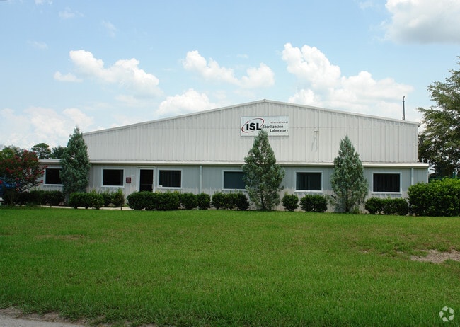
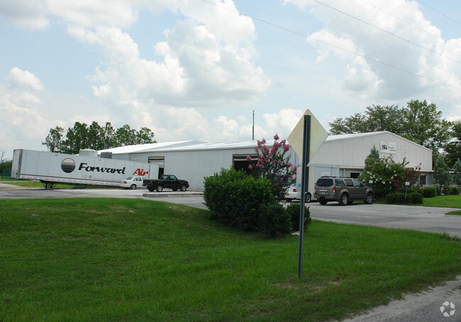
217 Sampey Rd
Orlando-Kissimmee-Sanford, FL
Groveland Farms
01-22-24-4305-017-00002
GROVELAND GROVELAND FARMS 20-22-25 BEG AT SE COR OF TRACT 17 & RUN W 582.45 FT TO SAMPY RD N 03-58-0 E ALONG SAID RD 301.79 FT E 215.52 FT N 58.07 FT E 347.37 FT S 359.64 FT TO POB--LESS FROM SE COR OF TRACT 17 RUN N 89-55-46 W ALONG S LINE OF SAID T
Lightindustrial
Lake
A
Florida
12069C0565E
17
2024
4.41 AC
2026
Lake County
031207
Orlando
16,906 SF
DEMOGRAPHICS near 217 Sampey Rd
1 Mile
3 Mile
5 Mile
2024 Total Population
2,595
19,525
40,964
2029 Population
3,021
22,839
48,195
Pop Growth 2024-2029
+ 16.42%
+ 16.97%
+ 17.65%
Average Age
37
38
39
2024 Total Households
846
6,629
14,181
HH Growth 2024-2029
+ 16.19%
+ 16.79%
+ 17.43%
Median Household Inc
$63,675
$70,294
$71,579
Avg Household Size
3.00
2.90
2.80
2024 Avg HH Vehicles
2.00
2.00
2.00
Median Home Value
$288,414
$271,340
$279,146
Median Year Built
2002
2004
2002
Nearby Places
Map Layers
Map Styles
 Street
 Aerial
- Restaurants
- Banks
- Shops
- Fitness
- Groceries
PUBLIC TRANSPORTATION
AIRPORT
Orlando International
DRIVE
WALK
Distance
Orlando International
54 min
38.7 mi
Freight Ports
Port of Tampa Bay
DRIVE
WALK
Distance
Port of Tampa Bay
93 min
73.2 mi
Nearby Properties
Address
Land Use
TOTAL SIZE
Lot Size
Zoning
Address
Land Use
TOTAL SIZE
Lot Size
Zoning
204,472 SF
43.52 AC
Address
Land Use
TOTAL SIZE
Lot Size
Zoning
92,400 SF
2.60 AC
Address
Land Use
TOTAL SIZE
Lot Size
Zoning
66,526 SF
8.98 AC
C1
Address
Land Use
TOTAL SIZE
Lot Size
Zoning
2,000 SF
55.61 AC
CFD
Address
Land Use
TOTAL SIZE
Lot Size
Zoning
2,000 SF
19.48 AC
SFLD
Address
Land Use
TOTAL SIZE
Lot Size
Zoning
92,250 SF
6.03 AC
C1
Address
Land Use
TOTAL SIZE
Lot Size
Zoning
95,060 SF
18.34 AC
M1
Address
Land Use
TOTAL SIZE
Lot Size
Zoning
34,619 SF
8.68 AC
CBD
Address
Land Use
TOTAL SIZE
Lot Size
Zoning
275.77 AC
R1
Address
Land Use
TOTAL SIZE
Lot Size
Zoning
49,052 SF
14.29 AC
R2
Address
Land Use
TOTAL SIZE
Lot Size
Zoning
2,000 SF
18.03 AC
R1
Address
Land Use
TOTAL SIZE
Lot Size
Zoning
13,358 SF
4.03 AC
C1
Address
Land Use
TOTAL SIZE
Lot Size
Zoning
2,000 SF
21.84 AC
R2
Address
Land Use
TOTAL SIZE
Lot Size
Zoning
18.77 AC
LM
Address
Land Use
TOTAL SIZE
Lot Size
Zoning
14,729 SF
1.87 AC
C1
Address
Land Use
TOTAL SIZE
Lot Size
Zoning
86,065 SF
10.27 AC
M1
Address
Land Use
TOTAL SIZE
Lot Size
Zoning
29,820 SF
3.21 AC
M1
Address
Land Use
TOTAL SIZE
Lot Size
Zoning
29,200 SF
6 AC
CFD
Address
Land Use
TOTAL SIZE
Lot Size
Zoning
7,008 SF
1.14 AC
Address
Land Use
TOTAL SIZE
Lot Size
Zoning
29.08 AC
AG
Address
Land Use
TOTAL SIZE
Lot Size
Zoning
36,138 SF
162.58 AC
CFD
Address
Land Use
TOTAL SIZE
Lot Size
Zoning
75,585 SF
4.24 AC
LM
Address
Land Use
TOTAL SIZE
Lot Size
Zoning
18,240 SF
3.61 AC
C1
Address
Land Use
TOTAL SIZE
Lot Size
Zoning
19,430 SF
1.45 AC
Address
Land Use
TOTAL SIZE
Lot Size
Zoning
40,864 SF
5.33 AC
Address
Land Use
TOTAL SIZE
Lot Size
Zoning
121,270 SF
19.74 AC
M1
Address
Land Use
TOTAL SIZE
Lot Size
Zoning
5,907 SF
1.12 AC
Address
Land Use
TOTAL SIZE
Lot Size
Zoning
18,840 SF
2.84 AC
Address
Land Use
TOTAL SIZE
Lot Size
Zoning
20,666 SF
5.05 AC
A
Address
Land Use
TOTAL SIZE
Lot Size
Zoning
5,036 SF
8.68 AC
R2
The World's #1 Commercial Real Estate Marketplace
Connect with us
© 2025 CoStar Group
The information above has been obtained from sources believed reliable. While we do not doubt its accuracy we have not verified it and make no guarantee, warranty or representation about it. It is your responsibility to independently confirm its accuracy and completeness. Any projections, opinions, assumptions, or estimates used are for example only and do not represent the current or future performance of the property. The value of this transaction to you depends on tax and other factors which should be evaluated by your tax, financial, and legal advisors. You and your advisors should conduct a careful, independent investigation of the property to determine to your satisfaction the suitability of the property for your needs.