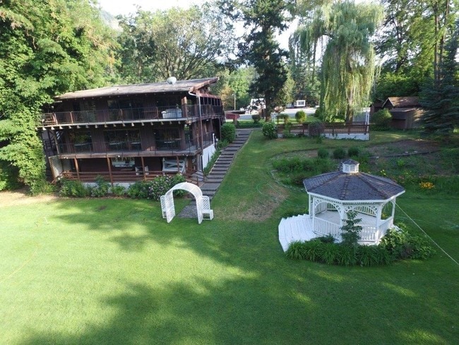
Property Record
2170 Rogue River Hwy, Grants Pass, OR 97527
Property Detail
2170 Rogue River Hwy
Grants Pass, OR
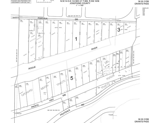
ORCHARD BEACH TRACTS, LOT 5 & 6, ACRES 1.34
R315311
JOSEPHINE
Commercialnec
Oregon
C-3
5&6
AE The base floodplain where base flood elevations are provided. AE Zones are now used on new format FIRMs instead of A1-A30 Zones.
0.41 AC
2024
Medford/Grants Pass
2025
Other Market Areas
361201
NEARBY LISTINGS FOR SALE OR LEASE
DEMOGRAPHICS near 2170 Rogue River Hwy
1 mile
3 mile
5 mile
2024 Total Population
5,129
33,389
52,335
2029 Population
5,181
33,140
52,058
Pop Growth 2024-2029
+ 1.01%
(0.75%)
(0.53%)
Average Age
42
43
44
2024 Total Households
2,144
13,604
21,219
HH Growth 2024-2029
+ 0.98%
(0.86%)
(0.63%)
Median Household Inc
$60,596
$61,262
$64,302
Avg Household Size
2.30
2.30
2.40
2024 Avg HH Vehicles
2.00
2.00
2.00
Median Home Value
$389,166
$380,678
$390,951
Median Year Built
1979
1977
1982
Nearby Places
Map Layers
Map Styles
 Street
 Aerial
Transit
 Traffic
 Biking
Places
Listings with unknown addresses are not visible on the map
- Restaurants
- Banks
- Shops
- Fitness
- Groceries
PUBLIC TRANSPORTATION
AIRPORT
Rogue Valley International - Medford
Drive
Walk
Distance
Rogue Valley International - Medford
35 min
25.1 mi
Freight Ports
Port of Coos Bay, OR
Drive
Walk
Distance
Port of Coos Bay, OR
188 min
139.8 mi
Nearby Properties
Address
Land Use
TOTAL SIZE
Lot Size
Zoning
Address
Land Use
TOTAL SIZE
Lot Size
Zoning
1,324,134 SF
9.03 AC
R-1-6
Address
Land Use
TOTAL SIZE
Lot Size
Zoning
74,405 SF
11.34 AC
GC
Address
Land Use
TOTAL SIZE
Lot Size
Zoning
49,752 SF
11.21 AC
R-2
Address
Land Use
TOTAL SIZE
Lot Size
Zoning
13,764 SF
3.32 AC
R-2
Address
Land Use
TOTAL SIZE
Lot Size
Zoning
11.54 AC
I
Address
Land Use
TOTAL SIZE
Lot Size
Zoning
360 SF
18.68 AC
I
Address
Land Use
TOTAL SIZE
Lot Size
Zoning
4,888 SF
2.58 AC
R-4,GC
Address
Land Use
TOTAL SIZE
Lot Size
Zoning
8,706 SF
13.73 AC
GC
Address
Land Use
TOTAL SIZE
Lot Size
Zoning
3.93 AC
R-3
Address
Land Use
TOTAL SIZE
Lot Size
Zoning
3.56 AC
GC
Address
Land Use
TOTAL SIZE
Lot Size
Zoning
Address
Land Use
TOTAL SIZE
Lot Size
Zoning
47,766 SF
2.02 AC
GC
Address
Land Use
TOTAL SIZE
Lot Size
Zoning
9.70 AC
BP
Address
Land Use
TOTAL SIZE
Lot Size
Zoning
8.48 AC
BP
Address
Land Use
TOTAL SIZE
Lot Size
Zoning
4,568 SF
5.71 AC
R-2
Address
Land Use
TOTAL SIZE
Lot Size
Zoning
34,446 SF
2.62 AC
IP
Address
Land Use
TOTAL SIZE
Lot Size
Zoning
76,830 SF
16.12 AC
R-3
Address
Land Use
TOTAL SIZE
Lot Size
Zoning
1,792 SF
6.15 AC
R-2
Address
Land Use
TOTAL SIZE
Lot Size
Zoning
66,148 SF
2.63 AC
I
Address
Land Use
TOTAL SIZE
Lot Size
Zoning
25,131 SF
5.22 AC
GC
Address
Land Use
TOTAL SIZE
Lot Size
Zoning
47,060 SF
10.65 AC
R-1-6
Address
Land Use
TOTAL SIZE
Lot Size
Zoning
111,774 SF
6.93 AC
R-3
Address
Land Use
TOTAL SIZE
Lot Size
Zoning
142,166 SF
12.41 AC
I
Address
Land Use
TOTAL SIZE
Lot Size
Zoning
9.70 AC
BP
Address
Land Use
TOTAL SIZE
Lot Size
Zoning
26,000 SF
9.12 AC
R-1-8
Address
Land Use
TOTAL SIZE
Lot Size
Zoning
20,000 SF
19.04 AC
R-1-8
Address
Land Use
TOTAL SIZE
Lot Size
Zoning
4,363 SF
15.58 AC
GC
Address
Land Use
TOTAL SIZE
Lot Size
Zoning
115,852 SF
8.79 AC
GC
Address
Land Use
TOTAL SIZE
Lot Size
Zoning
17,350 SF
6.63 AC
BP
Address
Land Use
TOTAL SIZE
Lot Size
Zoning
56,404 SF
2.82 AC
R-3
The World's #1 Commercial Real Estate Marketplace
Connect with us
© 2026 CoStar Group
The information above has been obtained from sources believed reliable. While we do not doubt its accuracy we have not verified it and make no guarantee, warranty or representation about it. It is your responsibility to independently confirm its accuracy and completeness. Any projections, opinions, assumptions, or estimates used are for example only and do not represent the current or future performance of the property. The value of this transaction to you depends on tax and other factors which should be evaluated by your tax, financial, and legal advisors. You and your advisors should conduct a careful, independent investigation of the property to determine to your satisfaction the suitability of the property for your needs.