Property Record
21700 Markham St, Perris, CA 92570
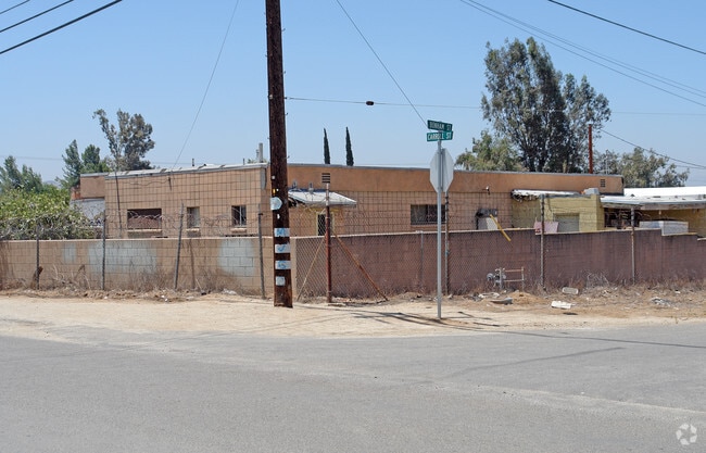


Property Detail
21700 Markham St
Riverside-San Bernardino-Ontario, CA
2.12 ACRES M/L IN LOTS 140, 141, 142 & 143 MB 014/099 UPTON ACRES 6
315-172-014
RIVERSIDE
Storebuilding
California
B and X Area of moderate flood hazard, usually the area between the limits of the 100-year and 500-year floods.
143
2024
2.12 AC
2025
Moreno Valley/Perris
042010
Inland Empire (California)
8,346 SF
NEARBY LISTINGS FOR SALE OR LEASE
DEMOGRAPHICS near 21700 Markham St
1 mile
3 mile
5 mile
2025 Total Population
6,512
25,559
138,235
2030 Population
6,639
26,177
141,196
Pop Growth 2025-2030
+ 1.95%
+ 2.42%
+ 2.14%
Average Age
35
36
35
2025 Total Households
1,444
6,339
35,029
HH Growth 2025-2030
+ 1.52%
+ 2.54%
+ 1.84%
Median Household Inc
$91,564
$99,086
$98,556
Avg Household Size
4.10
3.70
3.80
2025 Avg HH Vehicles
3.00
3.00
3.00
Median Home Value
$501,188
$611,250
$593,722
Median Year Built
1983
1986
1991
Nearby Places
Map Layers
Map Styles
 Street
 Aerial
Layers
 Traffic
 Biking
Places
Listings with unknown addresses are not visible on the map
- Restaurants
- Banks
- Shops
- Fitness
- Groceries
PUBLIC TRANSPORTATION
COMMUTER RAIL
Drive
Walk
Distance
12 min
6.6 mi
Drive
Walk
Distance
11 min
6.9 mi
AIRPORT
Ontario International
Drive
Walk
Distance
Ontario International
40 min
30.7 mi
Nearby Properties
Address
Land Use
TOTAL SIZE
Lot Size
Zoning
Address
Land Use
TOTAL SIZE
Lot Size
Zoning
1,851,898 SF
128.07 AC
Address
Land Use
TOTAL SIZE
Lot Size
Zoning
1,189,664 SF
55.26 AC
Address
Land Use
TOTAL SIZE
Lot Size
Zoning
782,209 SF
35.98 AC
Address
Land Use
TOTAL SIZE
Lot Size
Zoning
656,695 SF
30.75 AC
RA5
Address
Land Use
TOTAL SIZE
Lot Size
Zoning
1,138,800 SF
43.93 AC
Address
Land Use
TOTAL SIZE
Lot Size
Zoning
678,087 SF
30.24 AC
Address
Land Use
TOTAL SIZE
Lot Size
Zoning
1,547,145 SF
83.15 AC
Address
Land Use
TOTAL SIZE
Lot Size
Zoning
436,350 SF
19.47 AC
Address
Land Use
TOTAL SIZE
Lot Size
Zoning
692,465 SF
34.46 AC
Address
Land Use
TOTAL SIZE
Lot Size
Zoning
1,007,387 SF
48.02 AC
RR
Address
Land Use
TOTAL SIZE
Lot Size
Zoning
1,172,289 SF
41.82 AC
Address
Land Use
TOTAL SIZE
Lot Size
Zoning
348,375 SF
21.80 AC
Address
Land Use
TOTAL SIZE
Lot Size
Zoning
332,377 SF
21.12 AC
Address
Land Use
TOTAL SIZE
Lot Size
Zoning
1,582,985 SF
83.28 AC
LI
Address
Land Use
TOTAL SIZE
Lot Size
Zoning
285,482 SF
9.65 AC
Address
Land Use
TOTAL SIZE
Lot Size
Zoning
481,636 SF
45 AC
Address
Land Use
TOTAL SIZE
Lot Size
Zoning
800,218 SF
37.43 AC
Address
Land Use
TOTAL SIZE
Lot Size
Zoning
1,001,789 SF
44.53 AC
RR
Address
Land Use
TOTAL SIZE
Lot Size
Zoning
1,387,899 SF
49.40 AC
Address
Land Use
TOTAL SIZE
Lot Size
Zoning
406,650 SF
21.49 AC
Address
Land Use
TOTAL SIZE
Lot Size
Zoning
864,000 SF
43.64 AC
RA10
Address
Land Use
TOTAL SIZE
Lot Size
Zoning
753,895 SF
36.38 AC
Address
Land Use
TOTAL SIZE
Lot Size
Zoning
428,730 SF
16.85 AC
Address
Land Use
TOTAL SIZE
Lot Size
Zoning
410,350 SF
21.38 AC
Address
Land Use
TOTAL SIZE
Lot Size
Zoning
486,000 SF
24.62 AC
Address
Land Use
TOTAL SIZE
Lot Size
Zoning
262,260 SF
13.35 AC
RR
Address
Land Use
TOTAL SIZE
Lot Size
Zoning
1,224,406 SF
74.17 AC
The World's #1 Commercial Real Estate Marketplace
Connect with us
© 2026 CoStar Group
The information above has been obtained from sources believed reliable. While we do not doubt its accuracy we have not verified it and make no guarantee, warranty or representation about it. It is your responsibility to independently confirm its accuracy and completeness. Any projections, opinions, assumptions, or estimates used are for example only and do not represent the current or future performance of the property. The value of this transaction to you depends on tax and other factors which should be evaluated by your tax, financial, and legal advisors. You and your advisors should conduct a careful, independent investigation of the property to determine to your satisfaction the suitability of the property for your needs.