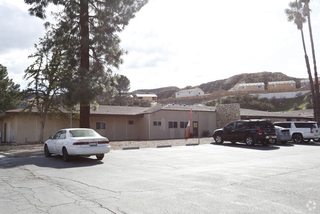
Property Record
21704 Golden Triangle Rd, Santa Clarita, CA 91350


Current Lease Availabilities
NEARBY LISTINGS FOR SALE OR LEASE
Property Detail
21704 Golden Triangle Rd
2836-015-017
The Rancho San Francisco
Officebuilding
RANCHO SAN FRANCISCO LOT COM N 32 5311 W 119.37 FT FROM MOST W COR OF LAND DESC IN DOC NO 1790 8-7-62 TO WALTER R OGDEN ET AL TH N 32 5311 W TO SE LINE OF S P R R R/W TH NE THEREON TO A LINE PARALLEL 456.58 FT FROM BEG TH S 78 14 W TO BEG
X
Los Angeles
06037C0817G
California
2024
4.81 AC
2025
Santa Clarita Valley
920314
Los Angeles
27,625 SF
Los Angeles-Long Beach-Glendale, CA
DEMOGRAPHICS near 21704 Golden Triangle Rd
1 Mile
3 Mile
5 Mile
2024 Total Population
3,114
110,465
221,673
2029 Population
3,043
106,539
213,759
Pop Growth 2024-2029
(2.28%)
(3.55%)
(3.57%)
Average Age
41
40
39
2024 Total Households
1,064
37,779
73,885
HH Growth 2024-2029
(3.10%)
(3.74%)
(3.80%)
Median Household Inc
$106,250
$104,758
$111,766
Avg Household Size
2.90
2.80
2.90
2024 Avg HH Vehicles
2.00
2.00
2.00
Median Home Value
$527,045
$696,903
$714,126
Median Year Built
1999
1984
1989
Nearby Places
Map Layers
Map Styles
 Street
 Aerial
- Restaurants
- Banks
- Shops
- Fitness
- Groceries
PUBLIC TRANSPORTATION
COMMUTER RAIL
Santa Clarita (Antelope Valley Line - Southern California Regional Rail Authority (Metrolink))
DRIVE
WALK
Distance
Santa Clarita (Antelope Valley Line - Southern California Regional Rail Authority (Metrolink))
4 min
1.4 mi
Via Princessa (Antelope Valley Line - Southern California Regional Rail Authority (Metrolink))
DRIVE
WALK
Distance
Via Princessa (Antelope Valley Line - Southern California Regional Rail Authority (Metrolink))
8 min
3.9 mi
AIRPORT
Bob Hope
DRIVE
WALK
Distance
Bob Hope
30 min
21.1 mi
Los Angeles International
DRIVE
WALK
Distance
Los Angeles International
51 min
38.2 mi
Freight Ports
The Port of Hueneme
DRIVE
WALK
Distance
The Port of Hueneme
79 min
54.6 mi
Nearby Properties
Address
Land Use
TOTAL SIZE
Lot Size
Zoning
Address
Land Use
TOTAL SIZE
Lot Size
Zoning
491,654 SF
17.56 AC
SCPI
Address
Land Use
TOTAL SIZE
Lot Size
Zoning
479,178 SF
14.17 AC
SCCR
Address
Land Use
TOTAL SIZE
Lot Size
Zoning
200,717 SF
7.62 AC
SCCR
Address
Land Use
TOTAL SIZE
Lot Size
Zoning
495,604 SF
38.40 AC
SCI
Address
Land Use
TOTAL SIZE
Lot Size
Zoning
194,907 SF
7.83 AC
SCSP
Address
Land Use
TOTAL SIZE
Lot Size
Zoning
97,733 SF
13.14 AC
SCCC
Address
Land Use
TOTAL SIZE
Lot Size
Zoning
266,614 SF
7.47 AC
SCSP
Address
Land Use
TOTAL SIZE
Lot Size
Zoning
161,103 SF
4.68 AC
SCUR4
Address
Land Use
TOTAL SIZE
Lot Size
Zoning
180,450 SF
5.08 AC
SCCR
Address
Land Use
TOTAL SIZE
Lot Size
Zoning
402,480 SF
13.58 AC
SCCN
Address
Land Use
TOTAL SIZE
Lot Size
Zoning
103,828 SF
6.23 AC
SCUR4
Address
Land Use
TOTAL SIZE
Lot Size
Zoning
83,698 SF
8.94 AC
SCPI
Address
Land Use
TOTAL SIZE
Lot Size
Zoning
174,562 SF
4.01 AC
SCCR
Address
Land Use
TOTAL SIZE
Lot Size
Zoning
132,668 SF
0.90 AC
SCCR
Address
Land Use
TOTAL SIZE
Lot Size
Zoning
2,355 SF
497.82 AC
SCSP
Address
Land Use
TOTAL SIZE
Lot Size
Zoning
131,425 SF
0.82 AC
SCCR
Address
Land Use
TOTAL SIZE
Lot Size
Zoning
196,958 SF
14.03 AC
SCUR5
Address
Land Use
TOTAL SIZE
Lot Size
Zoning
97,780 SF
14.98 AC
SCUR3
Address
Land Use
TOTAL SIZE
Lot Size
Zoning
216,067 SF
25.69 AC
SCBP
Address
Land Use
TOTAL SIZE
Lot Size
Zoning
86,201 SF
3.68 AC
SCUR4
Address
Land Use
TOTAL SIZE
Lot Size
Zoning
320,405 SF
8.03 AC
SCCR
Address
Land Use
TOTAL SIZE
Lot Size
Zoning
245,606 SF
11.67 AC
SCUR4
Address
Land Use
TOTAL SIZE
Lot Size
Zoning
78,596 SF
4.62 AC
SCCR
Address
Land Use
TOTAL SIZE
Lot Size
Zoning
3,840 SF
443.36 AC
SCSP
Address
Land Use
TOTAL SIZE
Lot Size
Zoning
350,399 SF
6.93 AC
SCCR
Address
Land Use
TOTAL SIZE
Lot Size
Zoning
354,338 SF
26.37 AC
SCCR
Address
Land Use
TOTAL SIZE
Lot Size
Zoning
180,492 SF
9.47 AC
SCUR4
Address
Land Use
TOTAL SIZE
Lot Size
Zoning
79,622 SF
1.21 AC
SCPI
Address
Land Use
TOTAL SIZE
Lot Size
Zoning
52,904 SF
3.08 AC
SCPI
The World's #1 Commercial Real Estate Marketplace
Connect with us
© 2026 CoStar Group
The information above has been obtained from sources believed reliable. While we do not doubt its accuracy we have not verified it and make no guarantee, warranty or representation about it. It is your responsibility to independently confirm its accuracy and completeness. Any projections, opinions, assumptions, or estimates used are for example only and do not represent the current or future performance of the property. The value of this transaction to you depends on tax and other factors which should be evaluated by your tax, financial, and legal advisors. You and your advisors should conduct a careful, independent investigation of the property to determine to your satisfaction the suitability of the property for your needs.