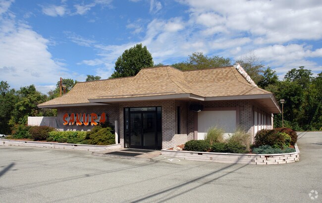
Property Record
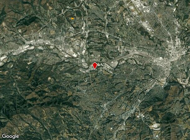
2171 Apperson Dr, Salem, VA 24153
NEARBY LISTINGS FOR SALE OR LEASE
Property Detail
2171 Apperson Dr
281-1-3
900
Commercialnec
0.466 AC LEE HI SHOPPING CENTER
X
Salem City
51161C0144G
Virginia
2025
0.47 AC
2025
Southwest Roanoke
010501
Roanoke
3,264 SF
Roanoke, VA
DEMOGRAPHICS near 2171 Apperson Dr
1 Mile
3 Mile
5 Mile
2024 Total Population
3,392
60,634
137,064
2029 Population
3,412
60,241
136,125
Pop Growth 2024-2029
+ 0.59%
(0.65%)
(0.69%)
Average Age
49
42
41
2024 Total Households
1,696
26,697
59,152
HH Growth 2024-2029
+ 0.53%
(0.64%)
(0.72%)
Median Household Inc
$59,789
$58,468
$59,168
Avg Household Size
1.90
2.20
2.20
2024 Avg HH Vehicles
2.00
2.00
2.00
Median Home Value
$252,827
$221,787
$226,408
Median Year Built
1972
1965
1967
Nearby Places
Map Layers
Map Styles
 Street
 Aerial
- Restaurants
- Banks
- Shops
- Fitness
- Groceries
PUBLIC TRANSPORTATION
COMMUTER RAIL
DRIVE
WALK
Distance
11 min
5.1 mi
AIRPORT
Roanoke/Blacksburg Regional (Woodrum Field)
DRIVE
WALK
Distance
Roanoke/Blacksburg Regional (Woodrum Field)
18 min
7.2 mi
SALE & LEASE HISTORY
LISTING DATE
SALE/LEASE

May 08, 2021
For Lease
Nearby Properties
Address
Land Use
TOTAL SIZE
Lot Size
Zoning
Address
Land Use
TOTAL SIZE
Lot Size
Zoning
160 AC
RSF
Address
Land Use
TOTAL SIZE
Lot Size
Zoning
41,443 SF
96.33 AC
INPUD
Address
Land Use
TOTAL SIZE
Lot Size
Zoning
81,148 SF
52.04 AC
CUDRSF
Address
Land Use
TOTAL SIZE
Lot Size
Zoning
421,634 SF
15.99 AC
HBD
Address
Land Use
TOTAL SIZE
Lot Size
Zoning
47,181 SF
33.94 AC
INPUD
Address
Land Use
TOTAL SIZE
Lot Size
Zoning
19,734 SF
34.83 AC
INPUD
Address
Land Use
TOTAL SIZE
Lot Size
Zoning
177,095 SF
18.55 AC
RMF
Address
Land Use
TOTAL SIZE
Lot Size
Zoning
69,831 SF
73.54 AC
HBD
Address
Land Use
TOTAL SIZE
Lot Size
Zoning
155,000 SF
3.78 AC
CUD
Address
Land Use
TOTAL SIZE
Lot Size
Zoning
180,301 SF
56.16 AC
R1S
Address
Land Use
TOTAL SIZE
Lot Size
Zoning
7,279 SF
24.35 AC
R3C
Address
Land Use
TOTAL SIZE
Lot Size
Zoning
181,455 SF
6.24 AC
RMF
Address
Land Use
TOTAL SIZE
Lot Size
Zoning
32,814 SF
18.14 AC
C1
Address
Land Use
TOTAL SIZE
Lot Size
Zoning
134,471 SF
16.39 AC
RMF
Address
Land Use
TOTAL SIZE
Lot Size
Zoning
6.29 AC
MXPUD
Address
Land Use
TOTAL SIZE
Lot Size
Zoning
76,280 SF
9.51 AC
CUD
Address
Land Use
TOTAL SIZE
Lot Size
Zoning
42,128 SF
32.68 AC
INPUD
Address
Land Use
TOTAL SIZE
Lot Size
Zoning
120,584 SF
9.41 AC
HM
Address
Land Use
TOTAL SIZE
Lot Size
Zoning
331,365 SF
61.27 AC
I-2
Address
Land Use
TOTAL SIZE
Lot Size
Zoning
118,647 SF
1.88 AC
IN
Address
Land Use
TOTAL SIZE
Lot Size
Zoning
565,151 SF
56.04 AC
HM
Address
Land Use
TOTAL SIZE
Lot Size
Zoning
122,462 SF
40.92 AC
INPUD
Address
Land Use
TOTAL SIZE
Lot Size
Zoning
28,221 SF
20.18 AC
RMF
Address
Land Use
TOTAL SIZE
Lot Size
Zoning
10,713 SF
12.44 AC
R3
Address
Land Use
TOTAL SIZE
Lot Size
Zoning
2,688 SF
21.40 AC
RMF
Address
Land Use
TOTAL SIZE
Lot Size
Zoning
159,727 SF
13.32 AC
C1
Address
Land Use
TOTAL SIZE
Lot Size
Zoning
442,530 SF
40.32 AC
HM
Address
Land Use
TOTAL SIZE
Lot Size
Zoning
11,529 SF
9.78 AC
R4
Address
Land Use
TOTAL SIZE
Lot Size
Zoning
32,286 SF
3.62 AC
RMF
Address
Land Use
TOTAL SIZE
Lot Size
Zoning
11,529 SF
9.75 AC
R4
The World's #1 Commercial Real Estate Marketplace
Connect with us
© 2025 CoStar Group
The information above has been obtained from sources believed reliable. While we do not doubt its accuracy we have not verified it and make no guarantee, warranty or representation about it. It is your responsibility to independently confirm its accuracy and completeness. Any projections, opinions, assumptions, or estimates used are for example only and do not represent the current or future performance of the property. The value of this transaction to you depends on tax and other factors which should be evaluated by your tax, financial, and legal advisors. You and your advisors should conduct a careful, independent investigation of the property to determine to your satisfaction the suitability of the property for your needs.