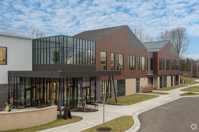
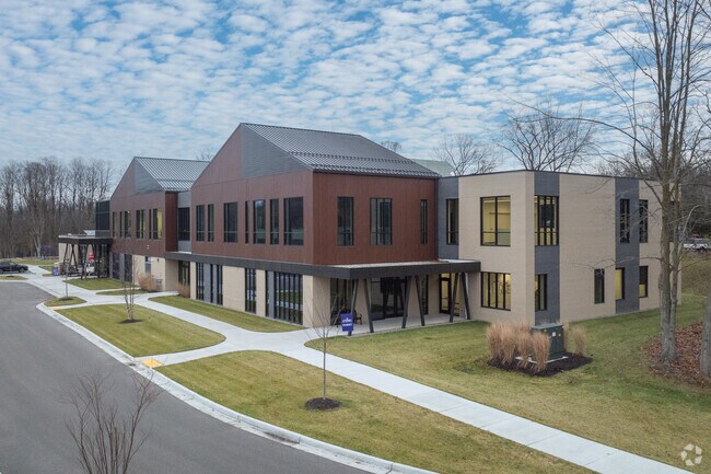
Property Record
2172 Dean Lake Ave Ne, Grand Rapids, MI 49505
NEARBY LISTINGS FOR SALE OR LEASE
Property Detail
2172 Dean Lake Ave Ne
Grand Rapids-Wyoming, MI
411409476019 S 138 FT OF NE 1/4 SE 1/4 ALSO N 264 FT OF W 1/2 SE 1/4 SE 1/4 * SEC 9 T7N R11W 8.18 A. SPLIT/COMBINED ON
41-14-09-476-019
Kent
Miscellaneous
Michigan
0
8.18 AC
2025
Central Grand Rapids
000300
West Michigan
47,370 SF
DEMOGRAPHICS near 2172 Dean Lake Ave Ne
1 Mile
3 Mile
5 Mile
2024 Total Population
6,396
68,376
189,223
2029 Population
6,426
68,771
190,332
Pop Growth 2024-2029
+ 0.47%
+ 0.58%
+ 0.59%
Average Age
42
39
37
2024 Total Households
2,913
28,316
77,412
HH Growth 2024-2029
+ 0.45%
+ 0.54%
+ 0.63%
Median Household Inc
$74,260
$70,883
$68,148
Avg Household Size
2.20
2.30
2.30
2024 Avg HH Vehicles
2.00
2.00
2.00
Median Home Value
$250,114
$232,622
$247,298
Median Year Built
1986
1962
1959
Nearby Places
Map Layers
Map Styles
 Street
 Aerial
- Restaurants
- Banks
- Shops
- Fitness
- Groceries
PUBLIC TRANSPORTATION
COMMUTER RAIL
Grand Rapids Vernon J. Ehlers Station (Pere Marquette - Amtrak)
DRIVE
WALK
Distance
Grand Rapids Vernon J. Ehlers Station (Pere Marquette - Amtrak)
12 min
5.9 mi
AIRPORT
Gerald R Ford International
DRIVE
WALK
Distance
Gerald R Ford International
22 min
13.7 mi
Freight Ports
Port Milwaukee
DRIVE
WALK
Distance
Port Milwaukee
314 min
267.6 mi
Nearby Properties
Address
Land Use
TOTAL SIZE
Lot Size
Zoning
Address
Land Use
TOTAL SIZE
Lot Size
Zoning
494,398 SF
R-PUD
Address
Land Use
TOTAL SIZE
Lot Size
Zoning
211,760 SF
TN-CC
Address
Land Use
TOTAL SIZE
Lot Size
Zoning
491,288 SF
2.79 AC
SD-PRD
Address
Land Use
TOTAL SIZE
Lot Size
Zoning
25.41 AC
Address
Land Use
TOTAL SIZE
Lot Size
Zoning
257,381 SF
7.08 AC
SD-PRD
Address
Land Use
TOTAL SIZE
Lot Size
Zoning
112,764 SF
17.29 AC
SD-PRD
Address
Land Use
TOTAL SIZE
Lot Size
Zoning
18.07 AC
MON-LDR
Address
Land Use
TOTAL SIZE
Lot Size
Zoning
21.77 AC
MCN-MDR
Address
Land Use
TOTAL SIZE
Lot Size
Zoning
18.65 AC
MCN-MDR
Address
Land Use
TOTAL SIZE
Lot Size
Zoning
Address
Land Use
TOTAL SIZE
Lot Size
Zoning
Address
Land Use
TOTAL SIZE
Lot Size
Zoning
109,482 SF
1.35 AC
SD-PRD
Address
Land Use
TOTAL SIZE
Lot Size
Zoning
24.96 AC
MCN-MDR
Address
Land Use
TOTAL SIZE
Lot Size
Zoning
247,954 SF
40.84 AC
SD-PRD
Address
Land Use
TOTAL SIZE
Lot Size
Zoning
158,449 SF
14.33 AC
MCN-MDR
Address
Land Use
TOTAL SIZE
Lot Size
Zoning
158,883 SF
16.53 AC
MCN-LDR
Address
Land Use
TOTAL SIZE
Lot Size
Zoning
21.10 AC
MON-MDR
Address
Land Use
TOTAL SIZE
Lot Size
Zoning
417,625 SF
29.60 AC
SD-IT
Address
Land Use
TOTAL SIZE
Lot Size
Zoning
145,127 SF
18.52 AC
SD-PRD
Address
Land Use
TOTAL SIZE
Lot Size
Zoning
22.63 AC
MCN-MDR
Address
Land Use
TOTAL SIZE
Lot Size
Zoning
11.01 AC
MCN-LDR
Address
Land Use
TOTAL SIZE
Lot Size
Zoning
34,120 SF
5.81 AC
SD-PRD
Address
Land Use
TOTAL SIZE
Lot Size
Zoning
56,095 SF
3.30 AC
SD-PRD
Address
Land Use
TOTAL SIZE
Lot Size
Zoning
16.34 AC
Address
Land Use
TOTAL SIZE
Lot Size
Zoning
80,898 SF
0.82 AC
SD-PRD
Address
Land Use
TOTAL SIZE
Lot Size
Zoning
13.26 AC
MON-MDR
Address
Land Use
TOTAL SIZE
Lot Size
Zoning
138,864 SF
34.91 AC
R-1
Address
Land Use
TOTAL SIZE
Lot Size
Zoning
375,083 SF
17.63 AC
SD-IT
Address
Land Use
TOTAL SIZE
Lot Size
Zoning
16.29 AC
MCN-MDR
The World's #1 Commercial Real Estate Marketplace
Connect with us
© 2026 CoStar Group
The information above has been obtained from sources believed reliable. While we do not doubt its accuracy we have not verified it and make no guarantee, warranty or representation about it. It is your responsibility to independently confirm its accuracy and completeness. Any projections, opinions, assumptions, or estimates used are for example only and do not represent the current or future performance of the property. The value of this transaction to you depends on tax and other factors which should be evaluated by your tax, financial, and legal advisors. You and your advisors should conduct a careful, independent investigation of the property to determine to your satisfaction the suitability of the property for your needs.