Property Record
2172 Lesslie Hwy, Rock Hill, SC 29730
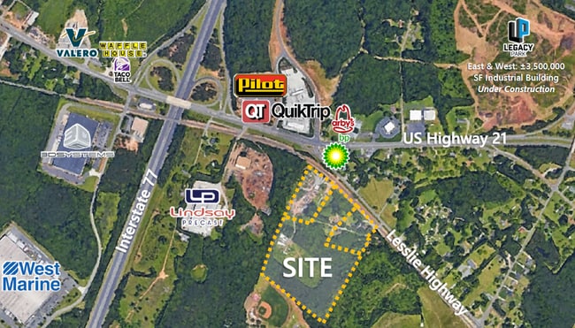
NEARBY LISTINGS FOR SALE OR LEASE
Property Detail
2172 Lesslie Hwy
6730000119
Property For Rosalind Jean Hepp Clyburn
Residentialnec
( 4.474 AC )
X
York
45091C0336F
South Carolina
2025
18.08 AC
2025
York County
061204
Charlotte
1,536 SF
Charlotte-Concord-Gastonia, NC-SC
DEMOGRAPHICS near 2172 Lesslie Hwy
1 Mile
3 Mile
5 Mile
2024 Total Population
820
24,270
77,827
2029 Population
924
27,353
87,556
Pop Growth 2024-2029
+ 12.68%
+ 12.70%
+ 12.50%
Average Age
42
39
38
2024 Total Households
340
9,981
30,859
HH Growth 2024-2029
+ 13.24%
+ 13.07%
+ 13.18%
Median Household Inc
$60,608
$50,601
$51,878
Avg Household Size
2.40
2.40
2.40
2024 Avg HH Vehicles
2.00
2.00
2.00
Median Home Value
$194,642
$173,627
$197,991
Median Year Built
1992
1986
1989
Nearby Places
- Restaurants
- Banks
- Shops
- Fitness
- Groceries
PUBLIC TRANSPORTATION
AIRPORT
Charlotte/Douglas International
DRIVE
WALK
Distance
Charlotte/Douglas International
38 min
23.8 mi
Freight Ports
North Charleston Terminal
DRIVE
WALK
Distance
North Charleston Terminal
196 min
175.5 mi
SALE & LEASE HISTORY
LISTING DATE
SALE/LEASE

Aug 21, 2020
For Sale
Nearby Properties
Address
Land Use
TOTAL SIZE
Lot Size
Zoning
Address
Land Use
TOTAL SIZE
Lot Size
Zoning
28,104 SF
11.84 AC
NMU
Address
Land Use
TOTAL SIZE
Lot Size
Zoning
10,448 SF
12.95 AC
PUD
Address
Land Use
TOTAL SIZE
Lot Size
Zoning
28,660 SF
19.95 AC
OI
Address
Land Use
TOTAL SIZE
Lot Size
Zoning
163,085 SF
6.84 AC
Address
Land Use
TOTAL SIZE
Lot Size
Zoning
68,486 SF
8.88 AC
IG
Address
Land Use
TOTAL SIZE
Lot Size
Zoning
29,196 SF
28.01 AC
Address
Land Use
TOTAL SIZE
Lot Size
Zoning
113,490 SF
7 AC
Address
Land Use
TOTAL SIZE
Lot Size
Zoning
851,500 SF
72.70 AC
Address
Land Use
TOTAL SIZE
Lot Size
Zoning
84,995 SF
5.09 AC
DTWN
Address
Land Use
TOTAL SIZE
Lot Size
Zoning
57,420 SF
4.72 AC
IG
Address
Land Use
TOTAL SIZE
Lot Size
Zoning
36,432 SF
17.92 AC
Address
Land Use
TOTAL SIZE
Lot Size
Zoning
219,972 SF
29.74 AC
IG
Address
Land Use
TOTAL SIZE
Lot Size
Zoning
471,456 SF
26 AC
ID
Address
Land Use
TOTAL SIZE
Lot Size
Zoning
460,800 SF
46.11 AC
Address
Land Use
TOTAL SIZE
Lot Size
Zoning
411,620 SF
30.34 AC
IG
Address
Land Use
TOTAL SIZE
Lot Size
Zoning
22,278 SF
4.92 AC
Address
Land Use
TOTAL SIZE
Lot Size
Zoning
28,956 SF
17.89 AC
MF15
Address
Land Use
TOTAL SIZE
Lot Size
Zoning
28,410 SF
18.78 AC
NMU
Address
Land Use
TOTAL SIZE
Lot Size
Zoning
231,000 SF
31.72 AC
Address
Land Use
TOTAL SIZE
Lot Size
Zoning
Address
Land Use
TOTAL SIZE
Lot Size
Zoning
237,723 SF
15.89 AC
PUD
Address
Land Use
TOTAL SIZE
Lot Size
Zoning
103.02 AC
RDI
Address
Land Use
TOTAL SIZE
Lot Size
Zoning
11,286 SF
1 AC
IH
Address
Land Use
TOTAL SIZE
Lot Size
Zoning
91.87 AC
UD
Address
Land Use
TOTAL SIZE
Lot Size
Zoning
14,320 SF
19.98 AC
MF15
Address
Land Use
TOTAL SIZE
Lot Size
Zoning
134,010 SF
21.08 AC
GC
Address
Land Use
TOTAL SIZE
Lot Size
Zoning
27,054 SF
10.41 AC
NMU
Address
Land Use
TOTAL SIZE
Lot Size
Zoning
193,960 SF
23.50 AC
Address
Land Use
TOTAL SIZE
Lot Size
Zoning
80.40 AC
RDI
Address
Land Use
TOTAL SIZE
Lot Size
Zoning
74.58 AC
SF5
The World's #1 Commercial Real Estate Marketplace
Connect with us
© 2025 CoStar Group
The information above has been obtained from sources believed reliable. While we do not doubt its accuracy we have not verified it and make no guarantee, warranty or representation about it. It is your responsibility to independently confirm its accuracy and completeness. Any projections, opinions, assumptions, or estimates used are for example only and do not represent the current or future performance of the property. The value of this transaction to you depends on tax and other factors which should be evaluated by your tax, financial, and legal advisors. You and your advisors should conduct a careful, independent investigation of the property to determine to your satisfaction the suitability of the property for your needs.