No Photo
Property Record
2173 N Expressway, Griffin, GA 30223

NEARBY LISTINGS FOR SALE OR LEASE
Property Detail
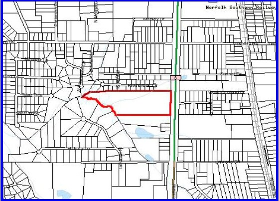
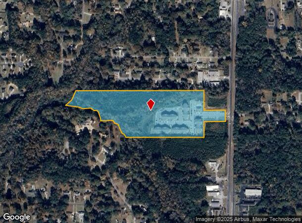
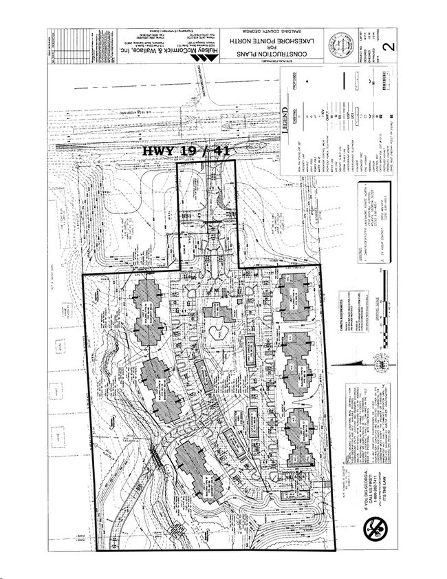
2173 N Expressway
Atlanta-Sandy Springs-Roswell, GA
Cumberland S/D
104-11-002
NORTH EXPRESSWAY 23.82 AC
Apartment
Spalding
A
Georgia
13255C0066E
92
2024
20.92 AC
2024
Spalding County
160500
Atlanta
115,608 SF
DEMOGRAPHICS near 2173 N Expressway
1 Mile
3 Mile
5 Mile
2024 Total Population
3,289
19,339
47,647
2029 Population
3,495
20,564
50,622
Pop Growth 2024-2029
+ 6.26%
+ 6.33%
+ 6.24%
Average Age
39
38
39
2024 Total Households
1,272
7,142
18,169
HH Growth 2024-2029
+ 6.29%
+ 6.30%
+ 6.18%
Median Household Inc
$52,732
$46,367
$49,285
Avg Household Size
2.60
2.60
2.50
2024 Avg HH Vehicles
2.00
2.00
2.00
Median Home Value
$136,598
$129,696
$171,462
Median Year Built
1983
1976
1982
Nearby Places
Map Layers
Map Styles
 Street
 Aerial
- Restaurants
- Banks
- Shops
- Fitness
- Groceries
PUBLIC TRANSPORTATION
AIRPORT
Hartsfield - Jackson Atlanta International
DRIVE
WALK
Distance
Hartsfield - Jackson Atlanta International
44 min
28.6 mi
Freight Ports
Georgia Ports - Savannah
DRIVE
WALK
Distance
Georgia Ports - Savannah
252 min
221.6 mi
SALE & LEASE HISTORY
LISTING DATE
SALE/LEASE

Sep 01, 2017
For Sale
Nearby Properties
Address
Land Use
TOTAL SIZE
Lot Size
Zoning
Address
Land Use
TOTAL SIZE
Lot Size
Zoning
200,880 SF
21.14 AC
PCD
Address
Land Use
TOTAL SIZE
Lot Size
Zoning
2,876 SF
19.98 AC
HDRB
Address
Land Use
TOTAL SIZE
Lot Size
Zoning
89,096 SF
22.41 AC
PCD
Address
Land Use
TOTAL SIZE
Lot Size
Zoning
133.41 AC
INST
Address
Land Use
TOTAL SIZE
Lot Size
Zoning
221,554 SF
23.89 AC
PCD
Address
Land Use
TOTAL SIZE
Lot Size
Zoning
10,000 SF
11.82 AC
PCD
Address
Land Use
TOTAL SIZE
Lot Size
Zoning
55.08 AC
R-1
Address
Land Use
TOTAL SIZE
Lot Size
Zoning
47,652 SF
2.59 AC
PCD
Address
Land Use
TOTAL SIZE
Lot Size
Zoning
4,118 SF
14.40 AC
PID
Address
Land Use
TOTAL SIZE
Lot Size
Zoning
72,870 SF
30 AC
Address
Land Use
TOTAL SIZE
Lot Size
Zoning
11,520 SF
8.77 AC
C-1B
Address
Land Use
TOTAL SIZE
Lot Size
Zoning
304,000 SF
11.92 AC
Address
Land Use
TOTAL SIZE
Lot Size
Zoning
102,102 SF
10.84 AC
PCD
Address
Land Use
TOTAL SIZE
Lot Size
Zoning
111,214 SF
6.01 AC
PCD
Address
Land Use
TOTAL SIZE
Lot Size
Zoning
18.07 AC
R1
Address
Land Use
TOTAL SIZE
Lot Size
Zoning
14.73 AC
INST
Address
Land Use
TOTAL SIZE
Lot Size
Zoning
50,382 SF
3.32 AC
C1
Address
Land Use
TOTAL SIZE
Lot Size
Zoning
20 AC
AR-1
Address
Land Use
TOTAL SIZE
Lot Size
Zoning
52,636 SF
2.69 AC
PCD
Address
Land Use
TOTAL SIZE
Lot Size
Zoning
63,109 SF
3.35 AC
INST
Address
Land Use
TOTAL SIZE
Lot Size
Zoning
29,572 SF
6 AC
PCD
Address
Land Use
TOTAL SIZE
Lot Size
Zoning
8,934 SF
14.21 AC
R3
Address
Land Use
TOTAL SIZE
Lot Size
Zoning
60,356 SF
7.03 AC
PCD
Address
Land Use
TOTAL SIZE
Lot Size
Zoning
22,520 SF
1.01 AC
C1
Address
Land Use
TOTAL SIZE
Lot Size
Zoning
109.46 AC
Address
Land Use
TOTAL SIZE
Lot Size
Zoning
85,794 SF
11.19 AC
PCD
Address
Land Use
TOTAL SIZE
Lot Size
Zoning
21,542 SF
7.53 AC
C-1B
Address
Land Use
TOTAL SIZE
Lot Size
Zoning
14,725 SF
1.94 AC
PCD
Address
Land Use
TOTAL SIZE
Lot Size
Zoning
10,438 SF
3.73 AC
PCD
The World's #1 Commercial Real Estate Marketplace
Connect with us
© 2026 CoStar Group
The information above has been obtained from sources believed reliable. While we do not doubt its accuracy we have not verified it and make no guarantee, warranty or representation about it. It is your responsibility to independently confirm its accuracy and completeness. Any projections, opinions, assumptions, or estimates used are for example only and do not represent the current or future performance of the property. The value of this transaction to you depends on tax and other factors which should be evaluated by your tax, financial, and legal advisors. You and your advisors should conduct a careful, independent investigation of the property to determine to your satisfaction the suitability of the property for your needs.