Property Record
2174 Sharp Ct, Fern Park, FL 32730


NEARBY LISTINGS FOR SALE OR LEASE
Property Detail
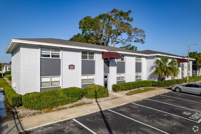
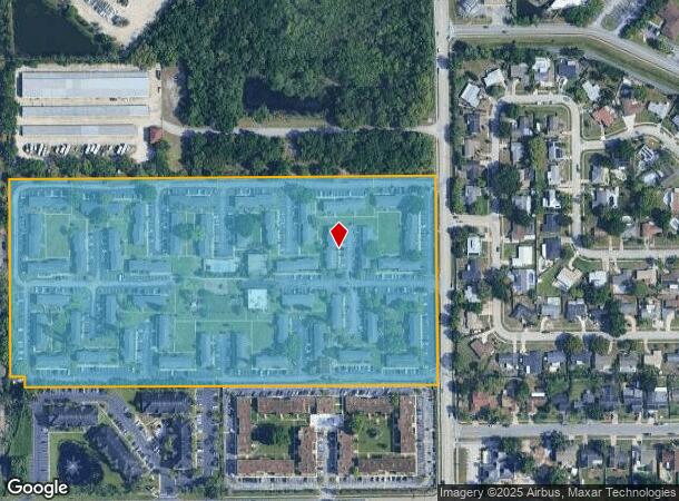
2174 Sharp Ct
20-21-30-300-001D-0000
Acreage & Unrec
Multifamilydwelling
SEC 20 TWP 21S RGE 30E BEG 372.38 FT S OF NW COR RUN E 1315.58 FT S 624.084 FT W TO A PT S OF BEG N TO BEG (LESS S 35 FT OF W 45 FT)
X
Seminole
12095C0165F
Florida
2025
19.35 AC
2025
Northeast Orlando
022006
Orlando
6,624 SF
Orlando-Kissimmee-Sanford, FL
DEMOGRAPHICS near 2174 Sharp Ct
1 Mile
3 Mile
5 Mile
2024 Total Population
12,054
96,651
265,271
2029 Population
12,423
100,604
276,173
Pop Growth 2024-2029
+ 3.06%
+ 4.09%
+ 4.11%
Average Age
41
42
41
2024 Total Households
5,077
41,916
112,222
HH Growth 2024-2029
+ 3.19%
+ 4.27%
+ 4.27%
Median Household Inc
$61,381
$61,794
$63,744
Avg Household Size
2.30
2.20
2.30
2024 Avg HH Vehicles
2.00
2.00
2.00
Median Home Value
$288,404
$303,246
$311,684
Median Year Built
1974
1978
1980
Nearby Places
Map Layers
Map Styles
 Street
 Aerial
- Restaurants
- Banks
- Shops
- Fitness
- Groceries
PUBLIC TRANSPORTATION
COMMUTER RAIL
Altamonte Springs (SunRail - Florida Department of Transportation)
DRIVE
WALK
Distance
Altamonte Springs (SunRail - Florida Department of Transportation)
4 min
1.9 mi
Maitland (SunRail - Florida Department of Transportation)
DRIVE
WALK
Distance
Maitland (SunRail - Florida Department of Transportation)
5 min
2.3 mi
AIRPORT
Orlando Sanford International
DRIVE
WALK
Distance
Orlando Sanford International
24 min
12.7 mi
Orlando International
DRIVE
WALK
Distance
Orlando International
29 min
17.1 mi
Freight Ports
Port Canaveral
DRIVE
WALK
Distance
Port Canaveral
75 min
59.5 mi
Nearby Properties
Address
Land Use
TOTAL SIZE
Lot Size
Zoning
Address
Land Use
TOTAL SIZE
Lot Size
Zoning
2,416 SF
29.71 AC
Address
Land Use
TOTAL SIZE
Lot Size
Zoning
88,256 SF
39.64 AC
MOC3
Address
Land Use
TOTAL SIZE
Lot Size
Zoning
423,270 SF
3.45 AC
MOC3
Address
Land Use
TOTAL SIZE
Lot Size
Zoning
467,832 SF
20.10 AC
PD
Address
Land Use
TOTAL SIZE
Lot Size
Zoning
21.25 AC
GC
Address
Land Use
TOTAL SIZE
Lot Size
Zoning
464,785 SF
2.19 AC
R-MF
Address
Land Use
TOTAL SIZE
Lot Size
Zoning
1,158 SF
17.22 AC
Address
Land Use
TOTAL SIZE
Lot Size
Zoning
508,923 SF
41.05 AC
C2
Address
Land Use
TOTAL SIZE
Lot Size
Zoning
1,400 SF
31.20 AC
A1
Address
Land Use
TOTAL SIZE
Lot Size
Zoning
656,009 SF
5.59 AC
DM
Address
Land Use
TOTAL SIZE
Lot Size
Zoning
Address
Land Use
TOTAL SIZE
Lot Size
Zoning
563,546 SF
0.61 AC
DM
Address
Land Use
TOTAL SIZE
Lot Size
Zoning
555,833 SF
3.65 AC
DM
Address
Land Use
TOTAL SIZE
Lot Size
Zoning
400 SF
13.82 AC
R1AA
Address
Land Use
TOTAL SIZE
Lot Size
Zoning
505,902 SF
4.69 AC
DM
Address
Land Use
TOTAL SIZE
Lot Size
Zoning
277,160 SF
2.38 AC
R-MF
Address
Land Use
TOTAL SIZE
Lot Size
Zoning
231,070 SF
35.59 AC
MOR2
Address
Land Use
TOTAL SIZE
Lot Size
Zoning
434,387 SF
26.01 AC
R3
Address
Land Use
TOTAL SIZE
Lot Size
Zoning
456 SF
9.56 AC
Address
Land Use
TOTAL SIZE
Lot Size
Zoning
322,180 SF
14.60 AC
A1
Address
Land Use
TOTAL SIZE
Lot Size
Zoning
1,428 SF
8.56 AC
MOR3
Address
Land Use
TOTAL SIZE
Lot Size
Zoning
377,321 SF
20.58 AC
R3A
Address
Land Use
TOTAL SIZE
Lot Size
Zoning
797,604 SF
3.31 AC
DM
Address
Land Use
TOTAL SIZE
Lot Size
Zoning
6,817 SF
19.84 AC
R3
Address
Land Use
TOTAL SIZE
Lot Size
Zoning
254,371 SF
15.63 AC
R1A
Address
Land Use
TOTAL SIZE
Lot Size
Zoning
254,477 SF
13.14 AC
MOR2
Address
Land Use
TOTAL SIZE
Lot Size
Zoning
409,338 SF
27.27 AC
RSF-2
Address
Land Use
TOTAL SIZE
Lot Size
Zoning
6,466 SF
18.97 AC
MOC3
Address
Land Use
TOTAL SIZE
Lot Size
Zoning
204 SF
30 AC
R3
Address
Land Use
TOTAL SIZE
Lot Size
Zoning
291,442 SF
19.09 AC
R3
The World's #1 Commercial Real Estate Marketplace
Connect with us
© 2025 CoStar Group
The information above has been obtained from sources believed reliable. While we do not doubt its accuracy we have not verified it and make no guarantee, warranty or representation about it. It is your responsibility to independently confirm its accuracy and completeness. Any projections, opinions, assumptions, or estimates used are for example only and do not represent the current or future performance of the property. The value of this transaction to you depends on tax and other factors which should be evaluated by your tax, financial, and legal advisors. You and your advisors should conduct a careful, independent investigation of the property to determine to your satisfaction the suitability of the property for your needs.