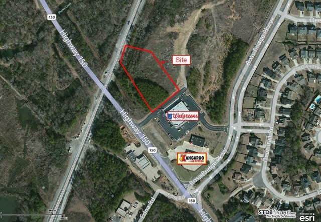
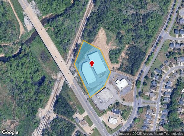
Property Record
2175 Highway 150, Hoover, AL 35244
NEARBY LISTINGS FOR SALE OR LEASE
Property Detail
2175 Highway 150
Birmingham, AL
Deer Valley Partners Addition
39-00-29-3-000-001.002
LOT 3 DEER VALLEY PARTNERS ADDITION TO HOOVER MB 47 MP 83
Commercialnec
Jefferson
X
Alabama
01073C0701H
3
2023
3.30 AC
2024
Hoover
014415
Birmingham
92,390 SF
DEMOGRAPHICS near 2175 Highway 150
1 Mile
3 Mile
5 Mile
2024 Total Population
4,771
29,102
83,315
2029 Population
4,582
28,574
84,335
Pop Growth 2024-2029
(3.96%)
(1.81%)
+ 1.22%
Average Age
38
40
39
2024 Total Households
1,653
10,407
32,035
HH Growth 2024-2029
(4.05%)
(1.98%)
+ 1.05%
Median Household Inc
$105,814
$120,807
$92,815
Avg Household Size
2.90
2.70
2.50
2024 Avg HH Vehicles
2.00
2.00
2.00
Median Home Value
$344,675
$363,435
$311,063
Median Year Built
2001
1998
1993
Nearby Places
Map Layers
Map Styles
 Street
 Aerial
- Restaurants
- Banks
- Shops
- Fitness
- Groceries
PUBLIC TRANSPORTATION
AIRPORT
Birmingham-Shuttlesworth International
DRIVE
WALK
Distance
Birmingham-Shuttlesworth International
32 min
21.2 mi
Freight Ports
Port of Mobile
DRIVE
WALK
Distance
Port of Mobile
276 min
251.9 mi
Nearby Properties
Address
Land Use
TOTAL SIZE
Lot Size
Zoning
Address
Land Use
TOTAL SIZE
Lot Size
Zoning
143,148 SF
15.60 AC
CP
Address
Land Use
TOTAL SIZE
Lot Size
Zoning
582,638 SF
43.76 AC
PUDP
Address
Land Use
TOTAL SIZE
Lot Size
Zoning
237,921 SF
6.35 AC
PUDP
Address
Land Use
TOTAL SIZE
Lot Size
Zoning
284,436 SF
40.98 AC
PUDP
Address
Land Use
TOTAL SIZE
Lot Size
Zoning
231,385 SF
50.40 AC
R6
Address
Land Use
TOTAL SIZE
Lot Size
Zoning
172,648 SF
39.45 AC
Address
Land Use
TOTAL SIZE
Lot Size
Zoning
185,856 SF
6.70 AC
PC
Address
Land Use
TOTAL SIZE
Lot Size
Zoning
105,299 SF
25.50 AC
T3
Address
Land Use
TOTAL SIZE
Lot Size
Zoning
83,700 SF
60 AC
PC
Address
Land Use
TOTAL SIZE
Lot Size
Zoning
94,329 SF
15.60 AC
C1
Address
Land Use
TOTAL SIZE
Lot Size
Zoning
35,503 SF
2.92 AC
C2
Address
Land Use
TOTAL SIZE
Lot Size
Zoning
208,000 SF
9.60 AC
SC-1
Address
Land Use
TOTAL SIZE
Lot Size
Zoning
41,374 SF
3.70 AC
PUD-
Address
Land Use
TOTAL SIZE
Lot Size
Zoning
108,525 SF
10.90 AC
PC
Address
Land Use
TOTAL SIZE
Lot Size
Zoning
23,493 SF
2.85 AC
C1
Address
Land Use
TOTAL SIZE
Lot Size
Zoning
130,568 SF
8.52 AC
SC-1
Address
Land Use
TOTAL SIZE
Lot Size
Zoning
64,321 SF
10.46 AC
PC
Address
Land Use
TOTAL SIZE
Lot Size
Zoning
76,255 SF
11.40 AC
C1
Address
Land Use
TOTAL SIZE
Lot Size
Zoning
52,440 SF
10.40 AC
C2
Address
Land Use
TOTAL SIZE
Lot Size
Zoning
3.30 AC
C4
Address
Land Use
TOTAL SIZE
Lot Size
Zoning
87,429 SF
6.80 AC
PC
Address
Land Use
TOTAL SIZE
Lot Size
Zoning
118,676 SF
4.09 AC
I2
Address
Land Use
TOTAL SIZE
Lot Size
Zoning
33,964 SF
5.80 AC
C1
Address
Land Use
TOTAL SIZE
Lot Size
Zoning
123,814 SF
10.15 AC
I2
Address
Land Use
TOTAL SIZE
Lot Size
Zoning
26,543 SF
1.90 AC
C4
Address
Land Use
TOTAL SIZE
Lot Size
Zoning
41,931 SF
14.50 AC
PC
Address
Land Use
TOTAL SIZE
Lot Size
Zoning
16,991 SF
3 AC
C4
Address
Land Use
TOTAL SIZE
Lot Size
Zoning
22,135 SF
12.65 AC
Address
Land Use
TOTAL SIZE
Lot Size
Zoning
51,119 SF
9.90 AC
PC
The World's #1 Commercial Real Estate Marketplace
Connect with us
© 2026 CoStar Group
The information above has been obtained from sources believed reliable. While we do not doubt its accuracy we have not verified it and make no guarantee, warranty or representation about it. It is your responsibility to independently confirm its accuracy and completeness. Any projections, opinions, assumptions, or estimates used are for example only and do not represent the current or future performance of the property. The value of this transaction to you depends on tax and other factors which should be evaluated by your tax, financial, and legal advisors. You and your advisors should conduct a careful, independent investigation of the property to determine to your satisfaction the suitability of the property for your needs.