Property Record
21759 State Road 7, Boca Raton, FL 33428

NEARBY LISTINGS FOR SALE OR LEASE
Property Detail
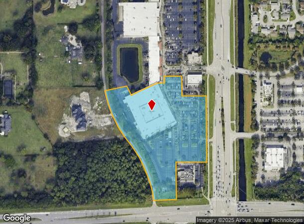
21759 State Road 7
00-41-47-24-09-001-0020
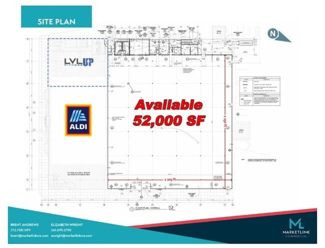
West Boca Square
Regionalshoppingcenterormallwithanchorstore
WEST BOCA SQUARE REPL PAR 1 (LESS NLY 46.69 FT OF WLY 46.59 FT LYG E OF & ADJ TO PAR 7)
X
Palm Beach
12099C1155F
Florida
2024
8.48 AC
2025
Palm Bch Cty Outlying
007731
South Florida
77,825 SF
West Palm Beach-Boca Raton-Delray Beach, FL
DEMOGRAPHICS near 21759 State Road 7
1 Mile
3 Mile
5 Mile
2024 Total Population
13,295
94,269
237,650
2029 Population
14,237
100,116
251,559
Pop Growth 2024-2029
+ 7.09%
+ 6.20%
+ 5.85%
Average Age
41
43
44
2024 Total Households
4,830
35,548
94,132
HH Growth 2024-2029
+ 6.29%
+ 5.92%
+ 5.84%
Median Household Inc
$75,340
$79,844
$83,961
Avg Household Size
2.60
2.50
2.40
2024 Avg HH Vehicles
2.00
2.00
2.00
Median Home Value
$398,125
$392,526
$409,539
Median Year Built
1985
1985
1987
Nearby Places
Map Layers
Map Styles
 Street
 Aerial
- Restaurants
- Banks
- Shops
- Fitness
- Groceries
PUBLIC TRANSPORTATION
COMMUTER RAIL
Deerfield Beach (Tri-County Commuter - South Florida Regional Transportation Authority (Tri-Rail))
DRIVE
WALK
Distance
Deerfield Beach (Tri-County Commuter - South Florida Regional Transportation Authority (Tri-Rail))
15 min
7.7 mi
AIRPORT
Fort Lauderdale/Hollywood International
DRIVE
WALK
Distance
Fort Lauderdale/Hollywood International
40 min
28.0 mi
Palm Beach International
DRIVE
WALK
Distance
Palm Beach International
42 min
30.3 mi
Freight Ports
Port Everglades
DRIVE
WALK
Distance
Port Everglades
39 min
26.7 mi
SALE & LEASE HISTORY
LISTING DATE
SALE/LEASE

May 08, 2025
For Lease
Nearby Properties
Address
Land Use
TOTAL SIZE
Lot Size
Zoning
Address
Land Use
TOTAL SIZE
Lot Size
Zoning
642,666 SF
16.33 AC
MXPD
Address
Land Use
TOTAL SIZE
Lot Size
Zoning
743,452 SF
25.24 AC
RTS
Address
Land Use
TOTAL SIZE
Lot Size
Zoning
30,972 SF
540.02 AC
PO
Address
Land Use
TOTAL SIZE
Lot Size
Zoning
600,712 SF
19.01 AC
AR
Address
Land Use
TOTAL SIZE
Lot Size
Zoning
393,810 SF
26.39 AC
RH
Address
Land Use
TOTAL SIZE
Lot Size
Zoning
421,779 SF
23.07 AC
PUD
Address
Land Use
TOTAL SIZE
Lot Size
Zoning
382,471 SF
32.64 AC
PUD
Address
Land Use
TOTAL SIZE
Lot Size
Zoning
477,479 SF
26.73 AC
RTS
Address
Land Use
TOTAL SIZE
Lot Size
Zoning
396,020 SF
70.57 AC
A-1
Address
Land Use
TOTAL SIZE
Lot Size
Zoning
360,216 SF
17.35 AC
PUD
Address
Land Use
TOTAL SIZE
Lot Size
Zoning
400,709 SF
29.62 AC
RH
Address
Land Use
TOTAL SIZE
Lot Size
Zoning
353,440 SF
9.80 AC
PUD
Address
Land Use
TOTAL SIZE
Lot Size
Zoning
8,925 SF
108.70 AC
PUD
Address
Land Use
TOTAL SIZE
Lot Size
Zoning
237,919 SF
23.46 AC
CG
Address
Land Use
TOTAL SIZE
Lot Size
Zoning
294,734 SF
59.90 AC
RS
Address
Land Use
TOTAL SIZE
Lot Size
Zoning
205,022 SF
19.03 AC
MXPD
Address
Land Use
TOTAL SIZE
Lot Size
Zoning
42,054 SF
318.18 AC
PO
Address
Land Use
TOTAL SIZE
Lot Size
Zoning
201,834 SF
22.09 AC
CG
Address
Land Use
TOTAL SIZE
Lot Size
Zoning
177,218 SF
17.79 AC
CG
Address
Land Use
TOTAL SIZE
Lot Size
Zoning
146,565 SF
17.06 AC
CG
Address
Land Use
TOTAL SIZE
Lot Size
Zoning
285,222 SF
56.63 AC
RT
Address
Land Use
TOTAL SIZE
Lot Size
Zoning
135,826 SF
17.15 AC
CG
Address
Land Use
TOTAL SIZE
Lot Size
Zoning
204,153 SF
17.19 AC
PUD
Address
Land Use
TOTAL SIZE
Lot Size
Zoning
130,440 SF
5.99 AC
RE
Address
Land Use
TOTAL SIZE
Lot Size
Zoning
188,849 SF
14.70 AC
CSH
Address
Land Use
TOTAL SIZE
Lot Size
Zoning
173,197 SF
19.28 AC
CG
Address
Land Use
TOTAL SIZE
Lot Size
Zoning
219,676 SF
5.78 AC
RH
Address
Land Use
TOTAL SIZE
Lot Size
Zoning
255,444 SF
8.45 AC
IL
Address
Land Use
TOTAL SIZE
Lot Size
Zoning
119,203 SF
12.46 AC
MUPD
Address
Land Use
TOTAL SIZE
Lot Size
Zoning
188,131 SF
8.16 AC
B-2
The World's #1 Commercial Real Estate Marketplace
Connect with us
© 2025 CoStar Group
The information above has been obtained from sources believed reliable. While we do not doubt its accuracy we have not verified it and make no guarantee, warranty or representation about it. It is your responsibility to independently confirm its accuracy and completeness. Any projections, opinions, assumptions, or estimates used are for example only and do not represent the current or future performance of the property. The value of this transaction to you depends on tax and other factors which should be evaluated by your tax, financial, and legal advisors. You and your advisors should conduct a careful, independent investigation of the property to determine to your satisfaction the suitability of the property for your needs.