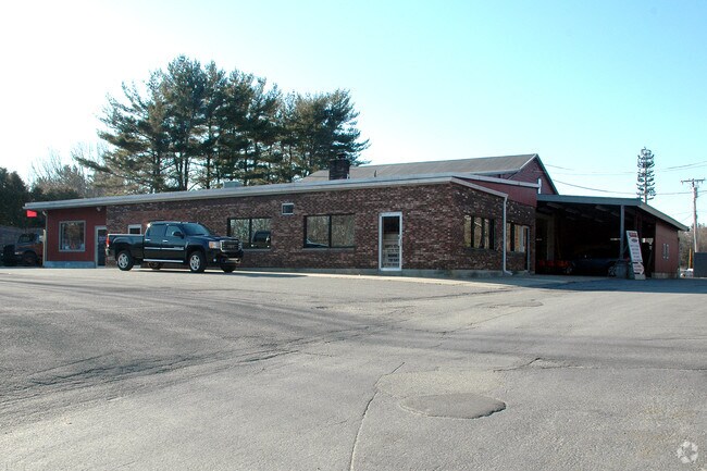
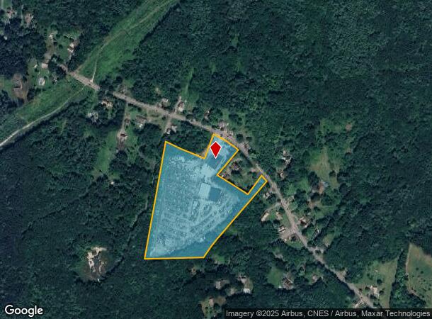
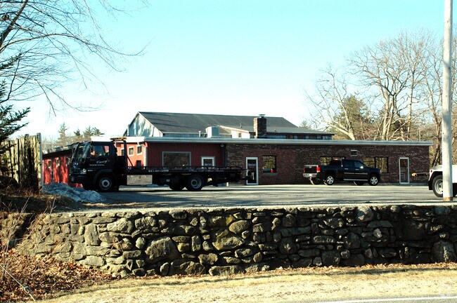
Property Record
2176 Main St, Lancaster, MA 01523
NEARBY LISTINGS FOR SALE OR LEASE
Property Detail
2176 Main St
LANC-000240-000000-000020
Worcester
Commercialnec
Massachusetts
X
2.0
25027C0452F
12.90 AC
2025
Outlying Worcester
2025
Boston
713100
Worcester, MA
14,700 SF
DEMOGRAPHICS near 2176 Main St
1 Mile
3 Mile
5 Mile
2024 Total Population
613
17,767
60,193
2029 Population
611
17,697
59,807
Pop Growth 2024-2029
(0.33%)
(0.39%)
(0.64%)
Average Age
43
42
42
2024 Total Households
139
6,678
23,222
HH Growth 2024-2029
+ 0.72%
(0.37%)
(0.68%)
Median Household Inc
$127,232
$85,568
$83,267
Avg Household Size
2.70
2.40
2.40
2024 Avg HH Vehicles
2.00
2.00
2.00
Median Home Value
$466,666
$354,787
$362,139
Median Year Built
1980
1979
1963
Nearby Places
Map Layers
Map Styles
 Street
 Aerial
- Restaurants
- Banks
- Shops
- Fitness
- Groceries
PUBLIC TRANSPORTATION
COMMUTER RAIL
North Leominster (Fitchburg/South Acton Line - Massachusetts Bay Transportation Authority Commuter Rail (Purple Line))
DRIVE
WALK
Distance
North Leominster (Fitchburg/South Acton Line - Massachusetts Bay Transportation Authority Commuter Rail (Purple Line))
8 min
5.2 mi
Shirley (Fitchburg/South Acton Line - Massachusetts Bay Transportation Authority Commuter Rail (Purple Line))
DRIVE
WALK
Distance
Shirley (Fitchburg/South Acton Line - Massachusetts Bay Transportation Authority Commuter Rail (Purple Line))
15 min
9.2 mi
AIRPORT
Worcester Regional
DRIVE
WALK
Distance
Worcester Regional
36 min
24.5 mi
Freight Ports
Port of Boston
DRIVE
WALK
Distance
Port of Boston
68 min
49.5 mi
Nearby Properties
Address
Land Use
TOTAL SIZE
Lot Size
Zoning
Address
Land Use
TOTAL SIZE
Lot Size
Zoning
24.35 AC
Address
Land Use
TOTAL SIZE
Lot Size
Zoning
45,066 SF
18.52 AC
Address
Land Use
TOTAL SIZE
Lot Size
Zoning
552,952 SF
27.44 AC
Address
Land Use
TOTAL SIZE
Lot Size
Zoning
20.30 AC
Address
Land Use
TOTAL SIZE
Lot Size
Zoning
9.30 AC
Address
Land Use
TOTAL SIZE
Lot Size
Zoning
68,822 SF
9.83 AC
Address
Land Use
TOTAL SIZE
Lot Size
Zoning
111,960 SF
4.75 AC
Address
Land Use
TOTAL SIZE
Lot Size
Zoning
171,063 SF
14.62 AC
Address
Land Use
TOTAL SIZE
Lot Size
Zoning
107,828 SF
7.41 AC
Address
Land Use
TOTAL SIZE
Lot Size
Zoning
274,272 SF
50 AC
Address
Land Use
TOTAL SIZE
Lot Size
Zoning
147,092 SF
36.90 AC
Address
Land Use
TOTAL SIZE
Lot Size
Zoning
102,628 SF
10.50 AC
Address
Land Use
TOTAL SIZE
Lot Size
Zoning
Address
Land Use
TOTAL SIZE
Lot Size
Zoning
81,594 SF
1.59 AC
Address
Land Use
TOTAL SIZE
Lot Size
Zoning
4.71 AC
Address
Land Use
TOTAL SIZE
Lot Size
Zoning
88,566 SF
29.46 AC
Address
Land Use
TOTAL SIZE
Lot Size
Zoning
59,587 SF
1.13 AC
Address
Land Use
TOTAL SIZE
Lot Size
Zoning
97,048 SF
6.85 AC
Address
Land Use
TOTAL SIZE
Lot Size
Zoning
116,116 SF
53.90 AC
Address
Land Use
TOTAL SIZE
Lot Size
Zoning
133,068 SF
9 AC
Address
Land Use
TOTAL SIZE
Lot Size
Zoning
171,354 SF
21.97 AC
Address
Land Use
TOTAL SIZE
Lot Size
Zoning
54,351 SF
4.82 AC
Address
Land Use
TOTAL SIZE
Lot Size
Zoning
5.37 AC
Address
Land Use
TOTAL SIZE
Lot Size
Zoning
9.16 AC
Address
Land Use
TOTAL SIZE
Lot Size
Zoning
45,066 SF
3.96 AC
Address
Land Use
TOTAL SIZE
Lot Size
Zoning
11.66 AC
Address
Land Use
TOTAL SIZE
Lot Size
Zoning
87,800 SF
57.40 AC
Address
Land Use
TOTAL SIZE
Lot Size
Zoning
45,060 SF
3.92 AC
Address
Land Use
TOTAL SIZE
Lot Size
Zoning
33,050 SF
7.80 AC
Address
Land Use
TOTAL SIZE
Lot Size
Zoning
70,516 SF
23 AC
The World's #1 Commercial Real Estate Marketplace
Connect with us
© 2026 CoStar Group
The information above has been obtained from sources believed reliable. While we do not doubt its accuracy we have not verified it and make no guarantee, warranty or representation about it. It is your responsibility to independently confirm its accuracy and completeness. Any projections, opinions, assumptions, or estimates used are for example only and do not represent the current or future performance of the property. The value of this transaction to you depends on tax and other factors which should be evaluated by your tax, financial, and legal advisors. You and your advisors should conduct a careful, independent investigation of the property to determine to your satisfaction the suitability of the property for your needs.