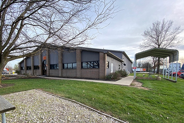
Property Record
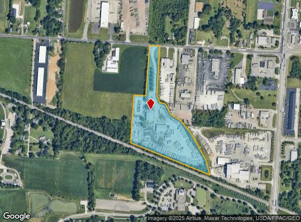
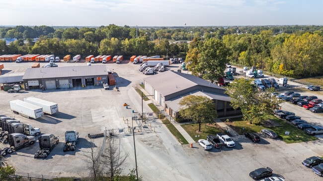
2177 Williams Rd, Columbus, OH 43207

NEARBY LISTINGS FOR SALE OR LEASE
Property Detail
2177 Williams Rd
153-000007
Mathews Surv
Warehouse
2177 WILLIAMS RD R22 T4 S13 12.927 ACRES
X
Franklin
39049C0343K
Ohio
2024
12.93 AC
2025
Southeast
009520
Columbus
19,941 SF
Columbus, OH
DEMOGRAPHICS near 2177 Williams Rd
1 mile
3 mile
5 mile
2024 Total Population
5,968
40,816
151,701
2029 Population
5,893
40,972
152,921
Pop Growth 2024-2029
(1.26%)
+ 0.38%
+ 0.80%
Average Age
37
39
38
2024 Total Households
2,256
15,899
61,922
HH Growth 2024-2029
(1.29%)
+ 0.40%
+ 0.80%
Median Household Inc
$65,000
$59,930
$52,649
Avg Household Size
2.60
2.50
2.40
2024 Avg HH Vehicles
2.00
2.00
2.00
Median Home Value
$164,643
$153,886
$166,505
Median Year Built
1988
1974
1964
Nearby Places
Map Layers
Map Styles
 Street
 Aerial
Transit
 Traffic
 Biking
Places
Listings with unknown addresses are not visible on the map
- Restaurants
- Banks
- Shops
- Fitness
- Groceries
PUBLIC TRANSPORTATION
AIRPORT
Rickenbacker International
Drive
Walk
Distance
Rickenbacker International
11 min
5.6 mi
John Glenn Columbus International
Drive
Walk
Distance
John Glenn Columbus International
20 min
10.7 mi
Freight Ports
Port of Toledo
Drive
Walk
Distance
Port of Toledo
197 min
157.0 mi
SALE & LEASE HISTORY
LISTING DATE
SALE/LEASE

Dec 11, 2020
For Sale
Nearby Properties
Address
Land Use
TOTAL SIZE
Lot Size
Zoning
Address
Land Use
TOTAL SIZE
Lot Size
Zoning
471,215 SF
49.74 AC
Address
Land Use
TOTAL SIZE
Lot Size
Zoning
1,021,020 SF
68.44 AC
Address
Land Use
TOTAL SIZE
Lot Size
Zoning
1,280,501 SF
69.60 AC
Address
Land Use
TOTAL SIZE
Lot Size
Zoning
778,272 SF
42.31 AC
Address
Land Use
TOTAL SIZE
Lot Size
Zoning
785,854 SF
30.85 AC
Address
Land Use
TOTAL SIZE
Lot Size
Zoning
541,910 SF
36.84 AC
Address
Land Use
TOTAL SIZE
Lot Size
Zoning
743,315 SF
42.17 AC
Address
Land Use
TOTAL SIZE
Lot Size
Zoning
130,865 SF
9.97 AC
Address
Land Use
TOTAL SIZE
Lot Size
Zoning
655,288 SF
40.76 AC
Address
Land Use
TOTAL SIZE
Lot Size
Zoning
705,600 SF
43.41 AC
Address
Land Use
TOTAL SIZE
Lot Size
Zoning
737,054 SF
37.15 AC
Address
Land Use
TOTAL SIZE
Lot Size
Zoning
250,174 SF
178.12 AC
Address
Land Use
TOTAL SIZE
Lot Size
Zoning
642,331 SF
25.16 AC
Address
Land Use
TOTAL SIZE
Lot Size
Zoning
478,544 SF
23.04 AC
Address
Land Use
TOTAL SIZE
Lot Size
Zoning
478,544 SF
24.25 AC
Address
Land Use
TOTAL SIZE
Lot Size
Zoning
462,840 SF
27.07 AC
Address
Land Use
TOTAL SIZE
Lot Size
Zoning
483,620 SF
28.80 AC
Address
Land Use
TOTAL SIZE
Lot Size
Zoning
107,200 SF
24.72 AC
Address
Land Use
TOTAL SIZE
Lot Size
Zoning
107,676 SF
14.15 AC
Address
Land Use
TOTAL SIZE
Lot Size
Zoning
352,500 SF
20.75 AC
Address
Land Use
TOTAL SIZE
Lot Size
Zoning
516,025 SF
24.18 AC
Address
Land Use
TOTAL SIZE
Lot Size
Zoning
389,476 SF
18.84 AC
Address
Land Use
TOTAL SIZE
Lot Size
Zoning
406,364 SF
22.03 AC
Address
Land Use
TOTAL SIZE
Lot Size
Zoning
455,654 SF
24.55 AC
Address
Land Use
TOTAL SIZE
Lot Size
Zoning
311,190 SF
21.90 AC
Address
Land Use
TOTAL SIZE
Lot Size
Zoning
276,284 SF
14.77 AC
Address
Land Use
TOTAL SIZE
Lot Size
Zoning
494,823 SF
28.93 AC
Address
Land Use
TOTAL SIZE
Lot Size
Zoning
257,400 SF
18.71 AC
Address
Land Use
TOTAL SIZE
Lot Size
Zoning
235,600 SF
11.25 AC
Address
Land Use
TOTAL SIZE
Lot Size
Zoning
604,078 SF
50.18 AC
The World's #1 Commercial Real Estate Marketplace
Connect with us
© 2026 CoStar Group
The information above has been obtained from sources believed reliable. While we do not doubt its accuracy we have not verified it and make no guarantee, warranty or representation about it. It is your responsibility to independently confirm its accuracy and completeness. Any projections, opinions, assumptions, or estimates used are for example only and do not represent the current or future performance of the property. The value of this transaction to you depends on tax and other factors which should be evaluated by your tax, financial, and legal advisors. You and your advisors should conduct a careful, independent investigation of the property to determine to your satisfaction the suitability of the property for your needs.