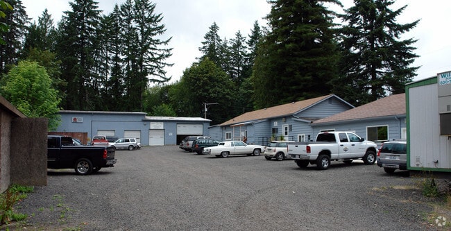
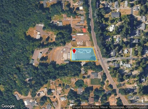
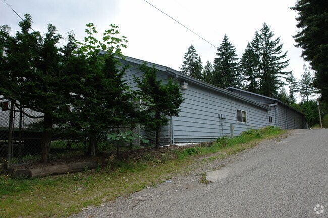
Property Record
2179 Chico Way Nw, Bremerton, WA 98312
NEARBY LISTINGS FOR SALE OR LEASE
Property Detail
2179 Chico Way Nw
082401-3-067-2003
BEGINNING AT THE SOUTHWEST CORNER OF THE NORTH HALF OF THE SOUTH HALF OF THE NORTHEAST QUARTER OF THE SOUTHWEST QUARTER, SECTION 8, TOWNSHIP 24 NORTH, RANGE 1 EAST, W.M.; THENCE NORTH 150 FEET; THENCE EAST TO THE WEST MARGIN OF STATE HIGHWAY 21; THEN
Warehouse
Kitsap
X
Washington
53035C0354F
0.90 AC
2025
West Kitsap County
2026
Bremerton/Silverdale
080900
Bremerton-Silverdale, WA
8,538 SF
DEMOGRAPHICS near 2179 Chico Way Nw
1 Mile
3 Mile
5 Mile
2024 Total Population
4,508
27,366
93,384
2029 Population
4,534
27,932
94,838
Pop Growth 2024-2029
+ 0.58%
+ 2.07%
+ 1.56%
Average Age
36
40
39
2024 Total Households
1,688
11,066
35,888
HH Growth 2024-2029
+ 0.53%
+ 2.20%
+ 1.73%
Median Household Inc
$71,032
$66,377
$69,790
Avg Household Size
2.60
2.40
2.40
2024 Avg HH Vehicles
2.00
2.00
2.00
Median Home Value
$441,538
$409,961
$394,696
Median Year Built
1978
1975
1978
Nearby Places
Map Layers
Map Styles
 Street
 Aerial
- Restaurants
- Banks
- Shops
- Fitness
- Groceries
Nearby Properties
Address
Land Use
TOTAL SIZE
Lot Size
Zoning
Address
Land Use
TOTAL SIZE
Lot Size
Zoning
21,408 SF
8.26 AC
BVSAP
Address
Land Use
TOTAL SIZE
Lot Size
Zoning
138,877 SF
7.17 AC
R-10
Address
Land Use
TOTAL SIZE
Lot Size
Zoning
66,022 SF
8.28 AC
RR
Address
Land Use
TOTAL SIZE
Lot Size
Zoning
112,847 SF
6.80 AC
UM
Address
Land Use
TOTAL SIZE
Lot Size
Zoning
68,079 SF
2.16 AC
BVSAP
Address
Land Use
TOTAL SIZE
Lot Size
Zoning
73,931 SF
11.72 AC
FC
Address
Land Use
TOTAL SIZE
Lot Size
Zoning
43,944 SF
2.64 AC
FC
Address
Land Use
TOTAL SIZE
Lot Size
Zoning
45,682 SF
2.04 AC
GC
Address
Land Use
TOTAL SIZE
Lot Size
Zoning
75,225 SF
3.30 AC
R-10
Address
Land Use
TOTAL SIZE
Lot Size
Zoning
55,866 SF
8.48 AC
FC
Address
Land Use
TOTAL SIZE
Lot Size
Zoning
48,520 SF
3.76 AC
GC
Address
Land Use
TOTAL SIZE
Lot Size
Zoning
52,461 SF
5.92 AC
RR
Address
Land Use
TOTAL SIZE
Lot Size
Zoning
42,665 SF
5.55 AC
FC
Address
Land Use
TOTAL SIZE
Lot Size
Zoning
52,601 SF
6.30 AC
BVSAP
Address
Land Use
TOTAL SIZE
Lot Size
Zoning
47,064 SF
5.27 AC
GC
Address
Land Use
TOTAL SIZE
Lot Size
Zoning
74,169 SF
2.62 AC
GC
Address
Land Use
TOTAL SIZE
Lot Size
Zoning
34,792 SF
1.89 AC
R-10
Address
Land Use
TOTAL SIZE
Lot Size
Zoning
46,395 SF
2.41 AC
FC
Address
Land Use
TOTAL SIZE
Lot Size
Zoning
28,982 SF
1.90 AC
GC
Address
Land Use
TOTAL SIZE
Lot Size
Zoning
40,131 SF
4.90 AC
FC
Address
Land Use
TOTAL SIZE
Lot Size
Zoning
2.31 AC
CITY
Address
Land Use
TOTAL SIZE
Lot Size
Zoning
36,094 SF
2.84 AC
FC
Address
Land Use
TOTAL SIZE
Lot Size
Zoning
30,367 SF
4.55 AC
FC
Address
Land Use
TOTAL SIZE
Lot Size
Zoning
29,694 SF
0.72 AC
R-10
Address
Land Use
TOTAL SIZE
Lot Size
Zoning
38,580 SF
2.44 AC
I
Address
Land Use
TOTAL SIZE
Lot Size
Zoning
42,400 SF
5.40 AC
FC
Address
Land Use
TOTAL SIZE
Lot Size
Zoning
28,000 SF
3.78 AC
FC
Address
Land Use
TOTAL SIZE
Lot Size
Zoning
7,767 SF
1 AC
UL
Address
Land Use
TOTAL SIZE
Lot Size
Zoning
26,644 SF
0.92 AC
R-10
Address
Land Use
TOTAL SIZE
Lot Size
Zoning
37,125 SF
2.02 AC
C
The World's #1 Commercial Real Estate Marketplace
Connect with us
© 2025 CoStar Group
The information above has been obtained from sources believed reliable. While we do not doubt its accuracy we have not verified it and make no guarantee, warranty or representation about it. It is your responsibility to independently confirm its accuracy and completeness. Any projections, opinions, assumptions, or estimates used are for example only and do not represent the current or future performance of the property. The value of this transaction to you depends on tax and other factors which should be evaluated by your tax, financial, and legal advisors. You and your advisors should conduct a careful, independent investigation of the property to determine to your satisfaction the suitability of the property for your needs.