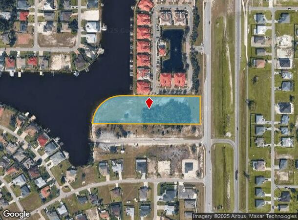
Property Record
218 Burnt Store Rd S, Cape Coral, FL 33991

NEARBY LISTINGS FOR SALE OR LEASE
Property Detail
218 Burnt Store Rd S
Cape Coral-Fort Myers, FL
Cape Coral
18-44-23-C2-05346.A000
CAPE CORAL UNIT 58 BLK 5346 PB 23 PG 140 TRACT A
Commercialacreage
Lee
AE
Florida
12071C0243G
a00
2024
3.34 AC
2025
Cape Coral
010419
Southwest Florida
DEMOGRAPHICS near 218 Burnt Store Rd S
1 Mile
3 Mile
5 Mile
2024 Total Population
5,055
31,734
89,677
2029 Population
6,175
38,240
107,555
Pop Growth 2024-2029
+ 22.16%
+ 20.50%
+ 19.94%
Average Age
45
42
41
2024 Total Households
1,888
11,569
32,101
HH Growth 2024-2029
+ 21.61%
+ 20.08%
+ 19.49%
Median Household Inc
$83,333
$75,118
$74,434
Avg Household Size
2.60
2.70
2.70
2024 Avg HH Vehicles
2.00
2.00
2.00
Median Home Value
$335,846
$314,511
$285,958
Median Year Built
2008
2007
2005
Nearby Places
Map Layers
Map Styles
 Street
 Aerial
- Restaurants
- Banks
- Shops
- Fitness
- Groceries
PUBLIC TRANSPORTATION
AIRPORT
Punta Gorda
DRIVE
WALK
Distance
Punta Gorda
33 min
21.1 mi
Southwest Florida International
DRIVE
WALK
Distance
Southwest Florida International
42 min
26.1 mi
SALE & LEASE HISTORY
LISTING DATE
SALE/LEASE

Oct 11, 2016
For Sale
Nearby Properties
Address
Land Use
TOTAL SIZE
Lot Size
Zoning
Address
Land Use
TOTAL SIZE
Lot Size
Zoning
507,243 SF
115.38 AC
A
Address
Land Use
TOTAL SIZE
Lot Size
Zoning
264,848 SF
10.36 AC
CORR
Address
Land Use
TOTAL SIZE
Lot Size
Zoning
239,211 SF
56.31 AC
INST
Address
Land Use
TOTAL SIZE
Lot Size
Zoning
27.77 AC
RML
Address
Land Use
TOTAL SIZE
Lot Size
Zoning
123,133 SF
8.26 AC
C
Address
Land Use
TOTAL SIZE
Lot Size
Zoning
147,599 SF
5.72 AC
RML
Address
Land Use
TOTAL SIZE
Lot Size
Zoning
142,379 SF
3.27 AC
Address
Land Use
TOTAL SIZE
Lot Size
Zoning
62,119 SF
6.50 AC
CORR
Address
Land Use
TOTAL SIZE
Lot Size
Zoning
64,461 SF
27.05 AC
RD-D
Address
Land Use
TOTAL SIZE
Lot Size
Zoning
102,818 SF
8.60 AC
CORR
Address
Land Use
TOTAL SIZE
Lot Size
Zoning
78,938 SF
11.39 AC
VILL
Address
Land Use
TOTAL SIZE
Lot Size
Zoning
78,740 SF
4.51 AC
C-1
Address
Land Use
TOTAL SIZE
Lot Size
Zoning
56,092 SF
4.52 AC
CORR
Address
Land Use
TOTAL SIZE
Lot Size
Zoning
20.12 AC
RD
Address
Land Use
TOTAL SIZE
Lot Size
Zoning
48,402 SF
6.20 AC
Address
Land Use
TOTAL SIZE
Lot Size
Zoning
16.86 AC
RD
Address
Land Use
TOTAL SIZE
Lot Size
Zoning
29,429 SF
3.27 AC
Address
Land Use
TOTAL SIZE
Lot Size
Zoning
45,121 SF
15.54 AC
RD-D
Address
Land Use
TOTAL SIZE
Lot Size
Zoning
41,231 SF
10.24 AC
A
Address
Land Use
TOTAL SIZE
Lot Size
Zoning
86,383 SF
4.87 AC
CORR
Address
Land Use
TOTAL SIZE
Lot Size
Zoning
17.21 AC
CORR
Address
Land Use
TOTAL SIZE
Lot Size
Zoning
61,338 SF
5.79 AC
CORR
Address
Land Use
TOTAL SIZE
Lot Size
Zoning
47,054 SF
3.65 AC
CORR
Address
Land Use
TOTAL SIZE
Lot Size
Zoning
26,947 SF
2.50 AC
C-1
Address
Land Use
TOTAL SIZE
Lot Size
Zoning
19,287 SF
3.82 AC
CORR
Address
Land Use
TOTAL SIZE
Lot Size
Zoning
2.78 AC
CCC
Address
Land Use
TOTAL SIZE
Lot Size
Zoning
26.27 AC
CORR
Address
Land Use
TOTAL SIZE
Lot Size
Zoning
810 SF
10.78 AC
AG-2
Address
Land Use
TOTAL SIZE
Lot Size
Zoning
30,610 SF
9.19 AC
RD-D
Address
Land Use
TOTAL SIZE
Lot Size
Zoning
3.42 AC
CORR
The World's #1 Commercial Real Estate Marketplace
Connect with us
© 2026 CoStar Group
The information above has been obtained from sources believed reliable. While we do not doubt its accuracy we have not verified it and make no guarantee, warranty or representation about it. It is your responsibility to independently confirm its accuracy and completeness. Any projections, opinions, assumptions, or estimates used are for example only and do not represent the current or future performance of the property. The value of this transaction to you depends on tax and other factors which should be evaluated by your tax, financial, and legal advisors. You and your advisors should conduct a careful, independent investigation of the property to determine to your satisfaction the suitability of the property for your needs.