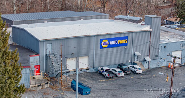
Property Record
218 Dupont Ave, Newburgh, NY 12550
NEARBY LISTINGS FOR SALE OR LEASE
Property Detail
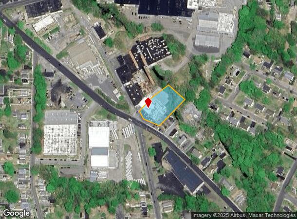
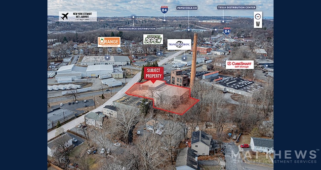
218 Dupont Ave
331100-013-000-0003-048.100-0000
LT 3D CREEK IND CENTER INC MAP 7617
Warehouse
Orange
AE
New York
36111C0900F
48.10
2024
0.79 AC
2024
Newburgh
000600
Northern New Jersey
27,920 SF
New York-Jersey City-White Plains, NY-NJ
DEMOGRAPHICS near 218 Dupont Ave
1 Mile
3 Mile
5 Mile
2024 Total Population
11,015
55,912
109,208
2029 Population
11,076
56,779
111,026
Pop Growth 2024-2029
+ 0.55%
+ 1.55%
+ 1.66%
Average Age
38
39
40
2024 Total Households
3,866
20,253
40,668
HH Growth 2024-2029
+ 0.49%
+ 1.66%
+ 1.77%
Median Household Inc
$77,572
$75,712
$86,338
Avg Household Size
2.80
2.60
2.50
2024 Avg HH Vehicles
2.00
2.00
2.00
Median Home Value
$205,065
$263,584
$313,108
Median Year Built
1949
1958
1966
Nearby Places
- Restaurants
- Banks
- Shops
- Fitness
- Groceries
PUBLIC TRANSPORTATION
COMMUTER RAIL
Beacon Station (Hudson Line - Metro-North Commuter Railroad Company (Metro-North))
DRIVE
WALK
Distance
Beacon Station (Hudson Line - Metro-North Commuter Railroad Company (Metro-North))
10 min
5.8 mi
AIRPORT
New York Stewart International
DRIVE
WALK
Distance
New York Stewart International
10 min
5.4 mi
Freight Ports
Port Newark Container Terminal
DRIVE
WALK
Distance
Port Newark Container Terminal
91 min
68.6 mi
SALE & LEASE HISTORY
LISTING DATE
SALE/LEASE

Feb 03, 2025
For Sale
Nearby Properties
Address
Land Use
TOTAL SIZE
Lot Size
Zoning
Address
Land Use
TOTAL SIZE
Lot Size
Zoning
211,240 SF
5.30 AC
WG
Address
Land Use
TOTAL SIZE
Lot Size
Zoning
325,026 SF
6.30 AC
RM
Address
Land Use
TOTAL SIZE
Lot Size
Zoning
355,349 SF
28.50 AC
RM
Address
Land Use
TOTAL SIZE
Lot Size
Zoning
345,572 SF
43.80 AC
R-1
Address
Land Use
TOTAL SIZE
Lot Size
Zoning
88,103 SF
32.60 AC
RH
Address
Land Use
TOTAL SIZE
Lot Size
Zoning
927,041 SF
104.37 AC
Address
Land Use
TOTAL SIZE
Lot Size
Zoning
272,943 SF
17 AC
RL
Address
Land Use
TOTAL SIZE
Lot Size
Zoning
110,384 SF
13.10 AC
RM
Address
Land Use
TOTAL SIZE
Lot Size
Zoning
112,136 SF
2.70 AC
RM
Address
Land Use
TOTAL SIZE
Lot Size
Zoning
45.48 AC
HI
Address
Land Use
TOTAL SIZE
Lot Size
Zoning
10,746 SF
11 AC
PWD
Address
Land Use
TOTAL SIZE
Lot Size
Zoning
182,318 SF
9.20 AC
RL
Address
Land Use
TOTAL SIZE
Lot Size
Zoning
91,705 SF
1.90 AC
RM
Address
Land Use
TOTAL SIZE
Lot Size
Zoning
130,037 SF
128.80 AC
Address
Land Use
TOTAL SIZE
Lot Size
Zoning
1.20 AC
Address
Land Use
TOTAL SIZE
Lot Size
Zoning
176,680 SF
1.28 AC
RM
Address
Land Use
TOTAL SIZE
Lot Size
Zoning
82,344 SF
1.80 AC
RH
Address
Land Use
TOTAL SIZE
Lot Size
Zoning
59,220 SF
6.40 AC
CD
Address
Land Use
TOTAL SIZE
Lot Size
Zoning
660.70 AC
AP
Address
Land Use
TOTAL SIZE
Lot Size
Zoning
69,006 SF
1.77 AC
DN
Address
Land Use
TOTAL SIZE
Lot Size
Zoning
213,521 SF
8 AC
RH
Address
Land Use
TOTAL SIZE
Lot Size
Zoning
739.80 AC
Address
Land Use
TOTAL SIZE
Lot Size
Zoning
94,608 SF
3.90 AC
RH
Address
Land Use
TOTAL SIZE
Lot Size
Zoning
71.72 AC
Address
Land Use
TOTAL SIZE
Lot Size
Zoning
107,016 SF
0.79 AC
WG
Address
Land Use
TOTAL SIZE
Lot Size
Zoning
44.50 AC
Address
Land Use
TOTAL SIZE
Lot Size
Zoning
505,577 SF
50.50 AC
Address
Land Use
TOTAL SIZE
Lot Size
Zoning
265,660 SF
24.20 AC
Address
Land Use
TOTAL SIZE
Lot Size
Zoning
57,330 SF
5.40 AC
WG
Address
Land Use
TOTAL SIZE
Lot Size
Zoning
229,085 SF
30.90 AC
04
The World's #1 Commercial Real Estate Marketplace
Connect with us
© 2025 CoStar Group
The information above has been obtained from sources believed reliable. While we do not doubt its accuracy we have not verified it and make no guarantee, warranty or representation about it. It is your responsibility to independently confirm its accuracy and completeness. Any projections, opinions, assumptions, or estimates used are for example only and do not represent the current or future performance of the property. The value of this transaction to you depends on tax and other factors which should be evaluated by your tax, financial, and legal advisors. You and your advisors should conduct a careful, independent investigation of the property to determine to your satisfaction the suitability of the property for your needs.