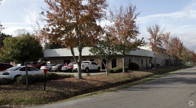
Property Record
218 Morgan Ave, Jacksonville, FL 32254


NEARBY LISTINGS FOR SALE OR LEASE
Property Detail
218 Morgan Ave
058472-0000
West Highway
Autorepair
3-18 17-2S-26E WEST HIGHWAY BLKS 10,11,CL ALLEY
X
Duval
12031C0353H
Florida
2025
2.86 AC
2026
Riverside
012100
Jacksonville (Florida)
19,141 SF
Jacksonville, FL
DEMOGRAPHICS near 218 Morgan Ave
1 mile
3 mile
5 mile
2024 Total Population
8,850
74,356
184,262
2029 Population
9,325
78,449
194,770
Pop Growth 2024-2029
+ 5.37%
+ 5.50%
+ 5.70%
Average Age
38
39
39
2024 Total Households
3,769
32,076
76,437
HH Growth 2024-2029
+ 5.41%
+ 5.64%
+ 5.96%
Median Household Inc
$42,023
$44,482
$43,248
Avg Household Size
2.30
2.20
2.30
2024 Avg HH Vehicles
1.00
1.00
1.00
Median Home Value
$141,504
$181,406
$175,807
Median Year Built
1950
1956
1962
Nearby Places
Map Layers
Map Styles
 Street
 Aerial
Transit
 Traffic
 Biking
Places
Listings with unknown addresses are not visible on the map
- Restaurants
- Banks
- Shops
- Fitness
- Groceries
PUBLIC TRANSPORTATION
COMMUTER RAIL
Drive
Walk
Distance
10 min
4.2 mi
AIRPORT
Jacksonville International
Drive
Walk
Distance
Jacksonville International
28 min
18.0 mi
Freight Ports
Jacksonville Port
Drive
Walk
Distance
Jacksonville Port
15 min
8.4 mi
Nearby Properties
Address
Land Use
TOTAL SIZE
Lot Size
Zoning
Address
Land Use
TOTAL SIZE
Lot Size
Zoning
629,459 SF
10.33 AC
PUD
Address
Land Use
TOTAL SIZE
Lot Size
Zoning
744,280 SF
53.40 AC
RMD-D
Address
Land Use
TOTAL SIZE
Lot Size
Zoning
355,967 SF
8.98 AC
PUD
Address
Land Use
TOTAL SIZE
Lot Size
Zoning
700,443 SF
8 AC
CCBD
Address
Land Use
TOTAL SIZE
Lot Size
Zoning
290,975 SF
4.49 AC
PUD
Address
Land Use
TOTAL SIZE
Lot Size
Zoning
465,664 SF
21.27 AC
IL
Address
Land Use
TOTAL SIZE
Lot Size
Zoning
888,083 SF
46.65 AC
IL
Address
Land Use
TOTAL SIZE
Lot Size
Zoning
352,439 SF
3.40 AC
CCBD
Address
Land Use
TOTAL SIZE
Lot Size
Zoning
222,138 SF
13.18 AC
IL
Address
Land Use
TOTAL SIZE
Lot Size
Zoning
594,573 SF
27.69 AC
IL
Address
Land Use
TOTAL SIZE
Lot Size
Zoning
290,599 SF
27.84 AC
RMD-D
Address
Land Use
TOTAL SIZE
Lot Size
Zoning
291,338 SF
37 AC
PBF-1
Address
Land Use
TOTAL SIZE
Lot Size
Zoning
147,066 SF
3.30 AC
PUD
Address
Land Use
TOTAL SIZE
Lot Size
Zoning
310,972 SF
19.91 AC
RMD-D
Address
Land Use
TOTAL SIZE
Lot Size
Zoning
233,363 SF
20.36 AC
PUD
Address
Land Use
TOTAL SIZE
Lot Size
Zoning
255,048 SF
20.15 AC
IL
Address
Land Use
TOTAL SIZE
Lot Size
Zoning
186,773 SF
9.77 AC
CCG-2
Address
Land Use
TOTAL SIZE
Lot Size
Zoning
100,600 SF
1.31 AC
PUD
Address
Land Use
TOTAL SIZE
Lot Size
Zoning
117,227 SF
14.32 AC
CCG-2
Address
Land Use
TOTAL SIZE
Lot Size
Zoning
129,506 SF
21.68 AC
CCG-2
Address
Land Use
TOTAL SIZE
Lot Size
Zoning
196,790 SF
12.62 AC
RMD-D
Address
Land Use
TOTAL SIZE
Lot Size
Zoning
240,410 SF
16.76 AC
IL
Address
Land Use
TOTAL SIZE
Lot Size
Zoning
26,680 SF
1.05 AC
PUD
Address
Land Use
TOTAL SIZE
Lot Size
Zoning
32,663 SF
2.56 AC
PUD
Address
Land Use
TOTAL SIZE
Lot Size
Zoning
169,370 SF
10.87 AC
RMD-D
Address
Land Use
TOTAL SIZE
Lot Size
Zoning
267,290 SF
11.81 AC
IL
Address
Land Use
TOTAL SIZE
Lot Size
Zoning
38,774 SF
1.72 AC
CCBD
Address
Land Use
TOTAL SIZE
Lot Size
Zoning
323,261 SF
56.62 AC
IL
Address
Land Use
TOTAL SIZE
Lot Size
Zoning
162,283 SF
14.29 AC
IL
Address
Land Use
TOTAL SIZE
Lot Size
Zoning
161,001 SF
10.32 AC
IL
The World's #1 Commercial Real Estate Marketplace
Connect with us
© 2026 CoStar Group
The information above has been obtained from sources believed reliable. While we do not doubt its accuracy we have not verified it and make no guarantee, warranty or representation about it. It is your responsibility to independently confirm its accuracy and completeness. Any projections, opinions, assumptions, or estimates used are for example only and do not represent the current or future performance of the property. The value of this transaction to you depends on tax and other factors which should be evaluated by your tax, financial, and legal advisors. You and your advisors should conduct a careful, independent investigation of the property to determine to your satisfaction the suitability of the property for your needs.