Property Record
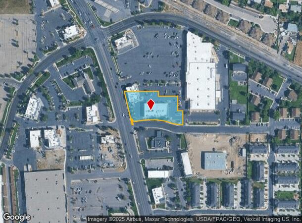
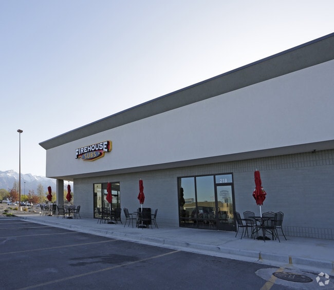
218 N West State Rd, American Fork, UT 84003

NEARBY LISTINGS FOR SALE OR LEASE
Property Detail
218 N West State Rd
Provo-Orem, UT
COM N 1611.13 FT & W 451.9 FT FR SE COR. SEC. 15, T5S, R1E, SLB&M.; N 89 DEG 39 31 W 19.04 FT; ALONG A CURVE TO R (CHORD BEARS: N 76 DEG 41 8 W 41.62 FT, RADIUS = 174 FT) ARC LENGTH = 41.72 FEET; ALONG A CURVE TO L (CHORD BEARS: N 86 DEG 35 24 W 217.
13-004-0065
Utah
Restaurantbuilding
Utah
2024
1.22 AC
2025
Utah County
000207
Salt Lake City
15,932 SF
DEMOGRAPHICS near 218 N West State Rd
1 Mile
3 Mile
5 Mile
2024 Total Population
11,559
80,812
171,729
2029 Population
13,516
94,487
200,928
Pop Growth 2024-2029
+ 16.93%
+ 16.92%
+ 17.00%
Average Age
32
32
32
2024 Total Households
3,430
23,027
47,357
HH Growth 2024-2029
+ 17.26%
+ 17.35%
+ 17.39%
Median Household Inc
$87,692
$96,151
$107,055
Avg Household Size
3.30
3.50
3.60
2024 Avg HH Vehicles
2.00
2.00
2.00
Median Home Value
$436,515
$485,369
$518,562
Median Year Built
1994
2001
2003
Nearby Places
Map Layers
Map Styles
 Street
 Aerial
- Restaurants
- Banks
- Shops
- Fitness
- Groceries
PUBLIC TRANSPORTATION
COMMUTER RAIL
American Fork Station (FrontRunner - Utah Transit Authority (UTA))
DRIVE
WALK
Distance
American Fork Station (FrontRunner - Utah Transit Authority (UTA))
5 min
1.9 mi
Lehi Station (FrontRunner - Utah Transit Authority (UTA))
DRIVE
WALK
Distance
Lehi Station (FrontRunner - Utah Transit Authority (UTA))
11 min
6.7 mi
AIRPORT
Provo Municipal
DRIVE
WALK
Distance
Provo Municipal
23 min
16.9 mi
Salt Lake City International
DRIVE
WALK
Distance
Salt Lake City International
41 min
34.7 mi
Freight Ports
Port of Stockton
DRIVE
WALK
Distance
Port of Stockton
742 min
725.1 mi
Nearby Properties
Address
Land Use
TOTAL SIZE
Lot Size
Zoning
Address
Land Use
TOTAL SIZE
Lot Size
Zoning
400,684 SF
10.39 AC
Address
Land Use
TOTAL SIZE
Lot Size
Zoning
322,826 SF
9.53 AC
Address
Land Use
TOTAL SIZE
Lot Size
Zoning
359,445 SF
6.46 AC
Address
Land Use
TOTAL SIZE
Lot Size
Zoning
305,553 SF
13.08 AC
Address
Land Use
TOTAL SIZE
Lot Size
Zoning
327,092 SF
14.61 AC
Address
Land Use
TOTAL SIZE
Lot Size
Zoning
146,939 SF
36.63 AC
Address
Land Use
TOTAL SIZE
Lot Size
Zoning
268,989 SF
12.78 AC
Address
Land Use
TOTAL SIZE
Lot Size
Zoning
8.99 AC
Address
Land Use
TOTAL SIZE
Lot Size
Zoning
154,800 SF
9.14 AC
Address
Land Use
TOTAL SIZE
Lot Size
Zoning
227,030 SF
21.91 AC
Address
Land Use
TOTAL SIZE
Lot Size
Zoning
213,863 SF
11.71 AC
Address
Land Use
TOTAL SIZE
Lot Size
Zoning
201,838 SF
8.83 AC
Address
Land Use
TOTAL SIZE
Lot Size
Zoning
141,635 SF
10.58 AC
Address
Land Use
TOTAL SIZE
Lot Size
Zoning
182,338 SF
7.97 AC
Address
Land Use
TOTAL SIZE
Lot Size
Zoning
153,790 SF
12.07 AC
Address
Land Use
TOTAL SIZE
Lot Size
Zoning
200,016 SF
8.82 AC
Address
Land Use
TOTAL SIZE
Lot Size
Zoning
122,777 SF
6.68 AC
Address
Land Use
TOTAL SIZE
Lot Size
Zoning
141,204 SF
11.96 AC
Address
Land Use
TOTAL SIZE
Lot Size
Zoning
149,937 SF
13.49 AC
Address
Land Use
TOTAL SIZE
Lot Size
Zoning
409,362 SF
29.53 AC
Address
Land Use
TOTAL SIZE
Lot Size
Zoning
102,751 SF
6.20 AC
Address
Land Use
TOTAL SIZE
Lot Size
Zoning
143,438 SF
7.43 AC
Address
Land Use
TOTAL SIZE
Lot Size
Zoning
100,814 SF
8.22 AC
Address
Land Use
TOTAL SIZE
Lot Size
Zoning
62,104 SF
8.97 AC
Address
Land Use
TOTAL SIZE
Lot Size
Zoning
172,506 SF
9.99 AC
Address
Land Use
TOTAL SIZE
Lot Size
Zoning
110,561 SF
6.47 AC
Address
Land Use
TOTAL SIZE
Lot Size
Zoning
109,875 SF
5.43 AC
Address
Land Use
TOTAL SIZE
Lot Size
Zoning
112,197 SF
7.10 AC
Address
Land Use
TOTAL SIZE
Lot Size
Zoning
154,411 SF
8.38 AC
Address
Land Use
TOTAL SIZE
Lot Size
Zoning
1,121 SF
4.07 AC
The World's #1 Commercial Real Estate Marketplace
Connect with us
© 2025 CoStar Group
The information above has been obtained from sources believed reliable. While we do not doubt its accuracy we have not verified it and make no guarantee, warranty or representation about it. It is your responsibility to independently confirm its accuracy and completeness. Any projections, opinions, assumptions, or estimates used are for example only and do not represent the current or future performance of the property. The value of this transaction to you depends on tax and other factors which should be evaluated by your tax, financial, and legal advisors. You and your advisors should conduct a careful, independent investigation of the property to determine to your satisfaction the suitability of the property for your needs.