Property Record
218 Springfield Rd, Baton Rouge, LA 70807
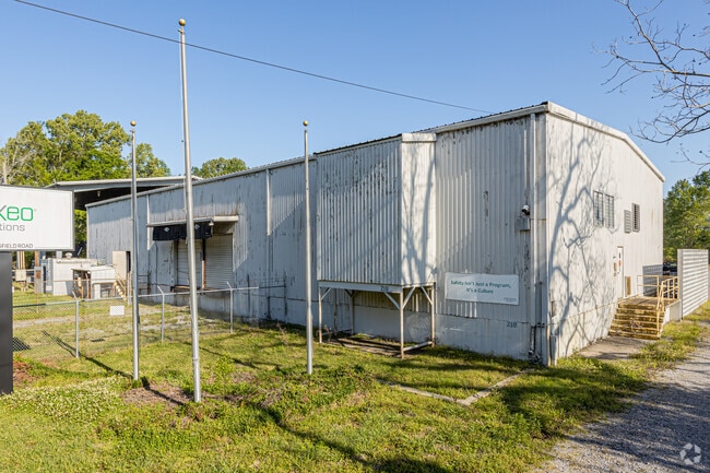


This Property Is For Sale
Current Lease Availabilities
Property Detail
218 Springfield Rd
Baton Rouge, LA
WARD: 2-5, SUBDIVISION: OLD SPRINGFIELD PLANTATION, LOT: A. LOT A, CONT. 1.86 ACRES, WARREN MUNSON PROPERTY, BEING A PORTION
01454684
East Baton Rouge
Storesoffices
Louisiana
A Areas with a 1% annual chance of flooding and a 26% chance of flooding over the life of a 30-year mortgage.
a
2025
1.86 AC
2025
East Baton Rouge Parish North
004603
Baton Rouge
12,175 SF
NEARBY LISTINGS FOR SALE OR LEASE
DEMOGRAPHICS near 218 Springfield Rd
1 mile
3 mile
5 mile
2025 Total Population
651
5,049
33,867
2030 Population
660
5,060
34,009
Pop Growth 2025-2030
+ 1.38%
+ 0.22%
+ 0.42%
Average Age
46
40
37
2025 Total Households
170
1,734
11,412
HH Growth 2025-2030
+ 2.35%
+ 0.17%
+ 0.45%
Median Household Inc
$24,650
$45,525
$41,350
Avg Household Size
2.30
2.50
2.50
2025 Avg HH Vehicles
2.00
2.00
2.00
Median Home Value
$161,249
$169,301
$154,377
Median Year Built
1976
1974
1976
Nearby Places
Map Layers
Map Styles
 Street
 Aerial
Layers
 Traffic
 Biking
Places
Listings with unknown addresses are not visible on the map
- Restaurants
- Banks
- Shops
- Fitness
- Groceries
PUBLIC TRANSPORTATION
AIRPORT
Baton Rouge Metro Ryan Field
Drive
Walk
Distance
Baton Rouge Metro Ryan Field
12 min
7.4 mi
Freight Ports
Port of Greater Baton Rouge
Drive
Walk
Distance
Port of Greater Baton Rouge
25 min
15.5 mi
Nearby Properties
Address
Land Use
TOTAL SIZE
Lot Size
Zoning
Address
Land Use
TOTAL SIZE
Lot Size
Zoning
Address
Land Use
TOTAL SIZE
Lot Size
Zoning
1.60 AC
Address
Land Use
TOTAL SIZE
Lot Size
Zoning
Address
Land Use
TOTAL SIZE
Lot Size
Zoning
14.74 AC
Address
Land Use
TOTAL SIZE
Lot Size
Zoning
87.06 AC
Address
Land Use
TOTAL SIZE
Lot Size
Zoning
29,945 SF
1.56 AC
Address
Land Use
TOTAL SIZE
Lot Size
Zoning
12.59 AC
Address
Land Use
TOTAL SIZE
Lot Size
Zoning
100,000 SF
7.48 AC
Address
Land Use
TOTAL SIZE
Lot Size
Zoning
Address
Land Use
TOTAL SIZE
Lot Size
Zoning
44,200 SF
6.53 AC
Address
Land Use
TOTAL SIZE
Lot Size
Zoning
36,750 SF
17.27 AC
Address
Land Use
TOTAL SIZE
Lot Size
Zoning
14.85 AC
Address
Land Use
TOTAL SIZE
Lot Size
Zoning
8,500 SF
3.18 AC
Address
Land Use
TOTAL SIZE
Lot Size
Zoning
7,863 SF
1,451.20 AC
Address
Land Use
TOTAL SIZE
Lot Size
Zoning
2.48 AC
Address
Land Use
TOTAL SIZE
Lot Size
Zoning
Address
Land Use
TOTAL SIZE
Lot Size
Zoning
226.35 AC
Address
Land Use
TOTAL SIZE
Lot Size
Zoning
8.01 AC
Address
Land Use
TOTAL SIZE
Lot Size
Zoning
6,489 SF
0.74 AC
Address
Land Use
TOTAL SIZE
Lot Size
Zoning
13,225 SF
1.34 AC
Address
Land Use
TOTAL SIZE
Lot Size
Zoning
4.77 AC
Address
Land Use
TOTAL SIZE
Lot Size
Zoning
53,200 SF
5.41 AC
Address
Land Use
TOTAL SIZE
Lot Size
Zoning
16,799 SF
1.53 AC
Address
Land Use
TOTAL SIZE
Lot Size
Zoning
31,228 SF
1.53 AC
Address
Land Use
TOTAL SIZE
Lot Size
Zoning
75,000 SF
39.31 AC
Address
Land Use
TOTAL SIZE
Lot Size
Zoning
24.51 AC
Address
Land Use
TOTAL SIZE
Lot Size
Zoning
2,216 SF
5 AC
The World's #1 Commercial Real Estate Marketplace
Connect with us
© 2026 CoStar Group
The information above has been obtained from sources believed reliable. While we do not doubt its accuracy we have not verified it and make no guarantee, warranty or representation about it. It is your responsibility to independently confirm its accuracy and completeness. Any projections, opinions, assumptions, or estimates used are for example only and do not represent the current or future performance of the property. The value of this transaction to you depends on tax and other factors which should be evaluated by your tax, financial, and legal advisors. You and your advisors should conduct a careful, independent investigation of the property to determine to your satisfaction the suitability of the property for your needs.