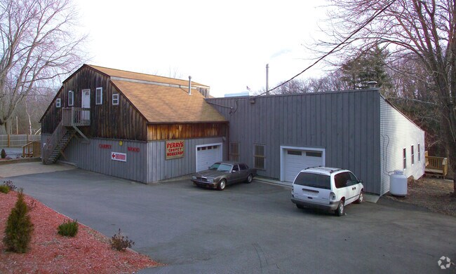
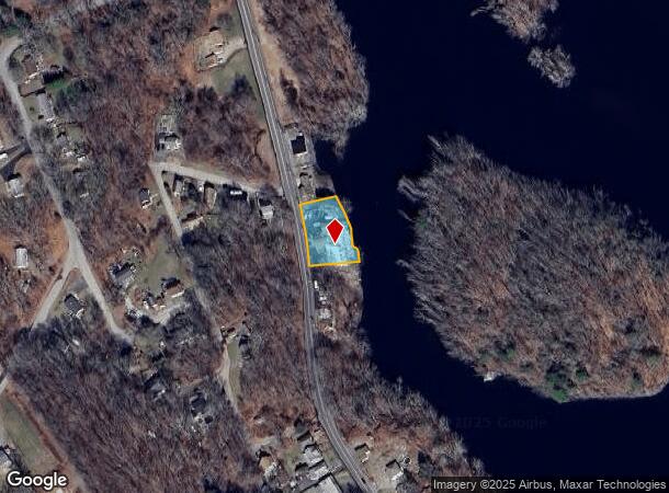
Property Record
218 Taftville Occum Rd, Norwich, CT 06360

NEARBY LISTINGS FOR SALE OR LEASE
-
-
View all Norwich listings for sale on LoopNet.com
Property Detail
218 Taftville Occum Rd
NORW-000032-000001-000015
New London
Commercialofficeresidentialmixeduse
Connecticut
AE
15
09011C0208G
0.41 AC
2025
NE New London/Norwich
2025
Hartford
696100
Norwich-New London, CT
9,346 SF
DEMOGRAPHICS near 218 Taftville Occum Rd
1 Mile
3 Mile
5 Mile
2024 Total Population
3,039
13,128
45,139
2029 Population
3,029
13,036
44,940
Pop Growth 2024-2029
(0.33%)
(0.70%)
(0.44%)
Average Age
41
42
40
2024 Total Households
1,391
5,526
18,577
HH Growth 2024-2029
(0.29%)
(0.74%)
(0.50%)
Median Household Inc
$54,762
$59,517
$62,092
Avg Household Size
2.10
2.30
2.30
2024 Avg HH Vehicles
2.00
2.00
2.00
Median Home Value
$209,225
$225,725
$226,153
Median Year Built
1959
1959
1956
Nearby Places
Map Layers
Map Styles
 Street
 Aerial
- Restaurants
- Banks
- Shops
- Fitness
- Groceries
PUBLIC TRANSPORTATION
AIRPORT
Rhode Island Tf Green International
DRIVE
WALK
Distance
Rhode Island Tf Green International
63 min
49.1 mi
Freight Ports
Port of Davisville, RI
DRIVE
WALK
Distance
Port of Davisville, RI
65 min
38.0 mi
Nearby Properties
Address
Land Use
TOTAL SIZE
Lot Size
Zoning
Address
Land Use
TOTAL SIZE
Lot Size
Zoning
200,847 SF
14.30 AC
R40
Address
Land Use
TOTAL SIZE
Lot Size
Zoning
21.33 AC
C4
Address
Land Use
TOTAL SIZE
Lot Size
Zoning
54.97 AC
GC
Address
Land Use
TOTAL SIZE
Lot Size
Zoning
128,565 SF
18.90 AC
R40
Address
Land Use
TOTAL SIZE
Lot Size
Zoning
182,533 SF
21.53 AC
C4
Address
Land Use
TOTAL SIZE
Lot Size
Zoning
1,500 SF
31.62 AC
600
Address
Land Use
TOTAL SIZE
Lot Size
Zoning
137,895 SF
11.28 AC
C4
Address
Land Use
TOTAL SIZE
Lot Size
Zoning
152,265 SF
131 SF
ID
Address
Land Use
TOTAL SIZE
Lot Size
Zoning
151,735 SF
131 SF
ID
Address
Land Use
TOTAL SIZE
Lot Size
Zoning
115,363 SF
16.51 AC
C4
Address
Land Use
TOTAL SIZE
Lot Size
Zoning
138,642 SF
9.94 AC
C4
Address
Land Use
TOTAL SIZE
Lot Size
Zoning
70,639 SF
14 AC
R-80
Address
Land Use
TOTAL SIZE
Lot Size
Zoning
77,971 SF
1.67 AC
C2
Address
Land Use
TOTAL SIZE
Lot Size
Zoning
83,453 SF
5.80 AC
MF
Address
Land Use
TOTAL SIZE
Lot Size
Zoning
244,369 SF
418.03 AC
I
Address
Land Use
TOTAL SIZE
Lot Size
Zoning
34,004 SF
16.32 AC
C4
Address
Land Use
TOTAL SIZE
Lot Size
Zoning
3.28 AC
R20
Address
Land Use
TOTAL SIZE
Lot Size
Zoning
85,044 SF
Address
Land Use
TOTAL SIZE
Lot Size
Zoning
151.60 AC
ROS
Address
Land Use
TOTAL SIZE
Lot Size
Zoning
135,573 SF
14.90 AC
I
Address
Land Use
TOTAL SIZE
Lot Size
Zoning
5,952 SF
15.08 AC
MF
Address
Land Use
TOTAL SIZE
Lot Size
Zoning
9.38 AC
MF
Address
Land Use
TOTAL SIZE
Lot Size
Zoning
36 AC
R40
Address
Land Use
TOTAL SIZE
Lot Size
Zoning
30,520 SF
8.66 AC
NC
Address
Land Use
TOTAL SIZE
Lot Size
Zoning
68.50 AC
R80
Address
Land Use
TOTAL SIZE
Lot Size
Zoning
26.01 AC
ROS
Address
Land Use
TOTAL SIZE
Lot Size
Zoning
65 AC
R80
Address
Land Use
TOTAL SIZE
Lot Size
Zoning
20.21 AC
R40
Address
Land Use
TOTAL SIZE
Lot Size
Zoning
16,056 SF
13.84 AC
R40
Address
Land Use
TOTAL SIZE
Lot Size
Zoning
26.38 AC
R40
The World's #1 Commercial Real Estate Marketplace
Connect with us
© 2025 CoStar Group
The information above has been obtained from sources believed reliable. While we do not doubt its accuracy we have not verified it and make no guarantee, warranty or representation about it. It is your responsibility to independently confirm its accuracy and completeness. Any projections, opinions, assumptions, or estimates used are for example only and do not represent the current or future performance of the property. The value of this transaction to you depends on tax and other factors which should be evaluated by your tax, financial, and legal advisors. You and your advisors should conduct a careful, independent investigation of the property to determine to your satisfaction the suitability of the property for your needs.