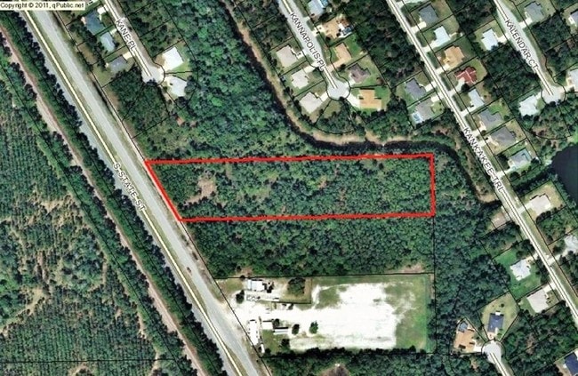
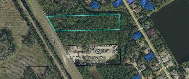
Property Record
2180 S State St, Bunnell, FL 32110

This Property Is For Sale
NEARBY LISTINGS FOR SALE OR LEASE
Property Detail
2180 S State St
Deltona-Daytona Beach-Ormond Beach, FL
Coastal Park Of Bunnell
24-12-30-0650-000C0-0102
4.071 AC THE N1/2 OF THE FOLLOWING DES PROPERTY BEING A PART OF TRACTS 10,11,12 OF BLK C PRO NE CRNR TR 12 THENCE S023910E - 392.91, S872050W - 737.44 TO ELY ROW US1, N314940W ALONG SAID ROW 450, N872050E - 956.81 TO POB OR 1442/831
Industrialacreage
Flagler
X
Florida
12035C0228E
102
2024
4.07 AC
2025
Daytona Area
060206
Other Market Areas
DEMOGRAPHICS near 2180 S State St
1 Mile
3 Mile
5 Mile
2024 Total Population
1,102
10,628
33,897
2029 Population
1,340
12,973
41,613
Pop Growth 2024-2029
+ 21.60%
+ 22.06%
+ 22.76%
Average Age
43
44
44
2024 Total Households
419
4,128
13,326
HH Growth 2024-2029
+ 20.76%
+ 21.34%
+ 22.07%
Median Household Inc
$71,041
$60,390
$58,836
Avg Household Size
2.60
2.50
2.50
2024 Avg HH Vehicles
2.00
2.00
2.00
Median Home Value
$278,499
$283,563
$262,508
Median Year Built
2004
2004
2005
Nearby Places
- Restaurants
- Banks
- Shops
- Fitness
- Groceries
PUBLIC TRANSPORTATION
AIRPORT
Daytona Beach International
DRIVE
WALK
Distance
Daytona Beach International
33 min
24.7 mi
Freight Ports
Jacksonville Port
DRIVE
WALK
Distance
Jacksonville Port
90 min
72.5 mi
Nearby Properties
Address
Land Use
TOTAL SIZE
Lot Size
Zoning
Address
Land Use
TOTAL SIZE
Lot Size
Zoning
913,614 SF
85.53 AC
PSP
Address
Land Use
TOTAL SIZE
Lot Size
Zoning
331,401 SF
36.51 AC
MFR-2
Address
Land Use
TOTAL SIZE
Lot Size
Zoning
320,259 SF
83.19 AC
P
Address
Land Use
TOTAL SIZE
Lot Size
Zoning
217,927 SF
1,165.37 AC
I-C
Address
Land Use
TOTAL SIZE
Lot Size
Zoning
280,742 SF
16.06 AC
MPD
Address
Land Use
TOTAL SIZE
Lot Size
Zoning
138,991 SF
18.66 AC
P
Address
Land Use
TOTAL SIZE
Lot Size
Zoning
121,173 SF
10 AC
AC
Address
Land Use
TOTAL SIZE
Lot Size
Zoning
64,208 SF
8.41 AC
PSP
Address
Land Use
TOTAL SIZE
Lot Size
Zoning
76,544 SF
48.85 AC
R/C
Address
Land Use
TOTAL SIZE
Lot Size
Zoning
220,314 SF
17.41 AC
MPD
Address
Land Use
TOTAL SIZE
Lot Size
Zoning
89,590 SF
9.90 AC
B-1
Address
Land Use
TOTAL SIZE
Lot Size
Zoning
59,889 SF
0.75 AC
R-3A
Address
Land Use
TOTAL SIZE
Lot Size
Zoning
67,008 SF
5.34 AC
B-1
Address
Land Use
TOTAL SIZE
Lot Size
Zoning
20,990 SF
18.10 AC
Address
Land Use
TOTAL SIZE
Lot Size
Zoning
120.23 AC
SFR-1
Address
Land Use
TOTAL SIZE
Lot Size
Zoning
4,158 SF
3.73 AC
P
Address
Land Use
TOTAL SIZE
Lot Size
Zoning
74,470 SF
11.98 AC
MPD
Address
Land Use
TOTAL SIZE
Lot Size
Zoning
43,990 SF
4.84 AC
P
Address
Land Use
TOTAL SIZE
Lot Size
Zoning
18,852 SF
3.23 AC
COM-2
Address
Land Use
TOTAL SIZE
Lot Size
Zoning
166.29 AC
PUD
Address
Land Use
TOTAL SIZE
Lot Size
Zoning
38,420 SF
4.83 AC
C-2(F)
Address
Land Use
TOTAL SIZE
Lot Size
Zoning
57.85 AC
MPD
Address
Land Use
TOTAL SIZE
Lot Size
Zoning
76,339 SF
4 AC
B-1
Address
Land Use
TOTAL SIZE
Lot Size
Zoning
10,310 SF
1.54 AC
Address
Land Use
TOTAL SIZE
Lot Size
Zoning
17,901 SF
1.72 AC
COM-2
Address
Land Use
TOTAL SIZE
Lot Size
Zoning
41,293 SF
4.92 AC
B-1
Address
Land Use
TOTAL SIZE
Lot Size
Zoning
65,787 SF
11.88 AC
B-1
Address
Land Use
TOTAL SIZE
Lot Size
Zoning
55,468 SF
7.25 AC
O-1
The World's #1 Commercial Real Estate Marketplace
Connect with us
© 2025 CoStar Group
The information above has been obtained from sources believed reliable. While we do not doubt its accuracy we have not verified it and make no guarantee, warranty or representation about it. It is your responsibility to independently confirm its accuracy and completeness. Any projections, opinions, assumptions, or estimates used are for example only and do not represent the current or future performance of the property. The value of this transaction to you depends on tax and other factors which should be evaluated by your tax, financial, and legal advisors. You and your advisors should conduct a careful, independent investigation of the property to determine to your satisfaction the suitability of the property for your needs.