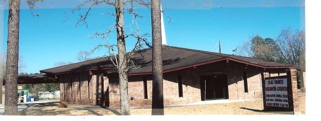
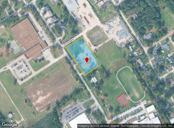
Property Record
21800 Rayford Rd, Humble, TX 77338
NEARBY LISTINGS FOR SALE OR LEASE
Property Detail
21800 Rayford Rd
0432090020313
Abst 543 A Mays
Religious
TR 15F-1 ABST 543 A MAYS
X
Harris
48339C0725G
Texas
0
2.11 AC
2025
Kingwood/Humble
240802
Houston
8,316 SF
Houston-The Woodlands-Sugar Land, TX
DEMOGRAPHICS near 21800 Rayford Rd
1 Mile
3 Mile
5 Mile
2024 Total Population
1,579
56,026
164,707
2029 Population
1,616
57,262
169,688
Pop Growth 2024-2029
+ 2.34%
+ 2.21%
+ 3.02%
Average Age
32
34
34
2024 Total Households
545
17,893
54,125
HH Growth 2024-2029
+ 2.20%
+ 2.16%
+ 3.04%
Median Household Inc
$42,234
$63,992
$61,509
Avg Household Size
2.80
3.10
3.00
2024 Avg HH Vehicles
2.00
2.00
2.00
Median Home Value
$158,053
$162,940
$173,952
Median Year Built
2003
1993
1999
Nearby Places
Map Layers
Map Styles
 Street
 Aerial
- Restaurants
- Banks
- Shops
- Fitness
- Groceries
PUBLIC TRANSPORTATION
AIRPORT
George Bush Intcntl/Houston
DRIVE
WALK
Distance
George Bush Intcntl/Houston
16 min
9.4 mi
William P Hobby
DRIVE
WALK
Distance
William P Hobby
52 min
33.5 mi
Freight Ports
Port of Houston
DRIVE
WALK
Distance
Port of Houston
40 min
27.4 mi
Nearby Properties
Address
Land Use
TOTAL SIZE
Lot Size
Zoning
Address
Land Use
TOTAL SIZE
Lot Size
Zoning
276,324 SF
33.79 AC
Address
Land Use
TOTAL SIZE
Lot Size
Zoning
350,423 SF
122.83 AC
Address
Land Use
TOTAL SIZE
Lot Size
Zoning
280,283 SF
16.56 AC
Address
Land Use
TOTAL SIZE
Lot Size
Zoning
271,432 SF
35.81 AC
Address
Land Use
TOTAL SIZE
Lot Size
Zoning
318,000 SF
18.53 AC
Address
Land Use
TOTAL SIZE
Lot Size
Zoning
204,870 SF
13.40 AC
Address
Land Use
TOTAL SIZE
Lot Size
Zoning
203,013 SF
12.28 AC
Address
Land Use
TOTAL SIZE
Lot Size
Zoning
175,495 SF
8.92 AC
Address
Land Use
TOTAL SIZE
Lot Size
Zoning
267,250 SF
11.83 AC
Address
Land Use
TOTAL SIZE
Lot Size
Zoning
99,561 SF
11.60 AC
Address
Land Use
TOTAL SIZE
Lot Size
Zoning
146,503 SF
6.12 AC
Address
Land Use
TOTAL SIZE
Lot Size
Zoning
125,674 SF
11.56 AC
Address
Land Use
TOTAL SIZE
Lot Size
Zoning
281,563 SF
19.98 AC
Address
Land Use
TOTAL SIZE
Lot Size
Zoning
152,440 SF
24.67 AC
Address
Land Use
TOTAL SIZE
Lot Size
Zoning
115,000 SF
7.83 AC
Address
Land Use
TOTAL SIZE
Lot Size
Zoning
126,320 SF
12.11 AC
Address
Land Use
TOTAL SIZE
Lot Size
Zoning
98,218 SF
29.44 AC
Address
Land Use
TOTAL SIZE
Lot Size
Zoning
78,116 SF
6.49 AC
Address
Land Use
TOTAL SIZE
Lot Size
Zoning
182,390 SF
47.72 AC
Address
Land Use
TOTAL SIZE
Lot Size
Zoning
56,524 SF
9.46 AC
Address
Land Use
TOTAL SIZE
Lot Size
Zoning
142,282 SF
23.63 AC
Address
Land Use
TOTAL SIZE
Lot Size
Zoning
100,408 SF
5.18 AC
Address
Land Use
TOTAL SIZE
Lot Size
Zoning
79,899 SF
7.05 AC
Address
Land Use
TOTAL SIZE
Lot Size
Zoning
125,472 SF
5.14 AC
Address
Land Use
TOTAL SIZE
Lot Size
Zoning
55,724 SF
9.42 AC
Address
Land Use
TOTAL SIZE
Lot Size
Zoning
58.19 AC
Address
Land Use
TOTAL SIZE
Lot Size
Zoning
61,357 SF
6.11 AC
Address
Land Use
TOTAL SIZE
Lot Size
Zoning
6.72 AC
Address
Land Use
TOTAL SIZE
Lot Size
Zoning
241,100 SF
20.06 AC
Address
Land Use
TOTAL SIZE
Lot Size
Zoning
75,600 SF
8.36 AC
The World's #1 Commercial Real Estate Marketplace
Connect with us
© 2025 CoStar Group
The information above has been obtained from sources believed reliable. While we do not doubt its accuracy we have not verified it and make no guarantee, warranty or representation about it. It is your responsibility to independently confirm its accuracy and completeness. Any projections, opinions, assumptions, or estimates used are for example only and do not represent the current or future performance of the property. The value of this transaction to you depends on tax and other factors which should be evaluated by your tax, financial, and legal advisors. You and your advisors should conduct a careful, independent investigation of the property to determine to your satisfaction the suitability of the property for your needs.