Property Record
21813 Ne Rodda Rd, Battle Ground, WA 98604

NEARBY LISTINGS FOR SALE OR LEASE
Property Detail
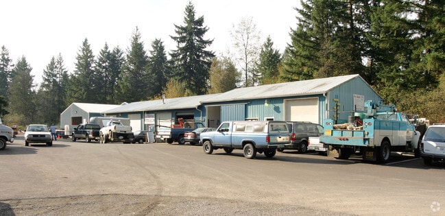
21813 Ne Rodda Rd
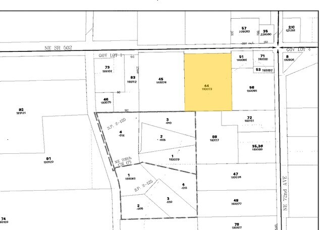
193073-000
#44 SEC 6 T3N R2EWM 3.06A FOR ASSESSOR USE ONLY (AFN 6172311) COMMENCING AT THE NORTHEAST CORNER OF SAID SECTION 6; THENCE SOUTH 001118 WEST. ALONG THE EAST LINE OF SAID SECTION 6, FOR A DISTANCE OF 436.97 FEET; THENCE SOUTH 895214 WEST. FOR A DISTAN
Autorepair
Clark
AE
Washington
53011C0238D
3.06 AC
2025
Clark County Outlying
2025
Portland
040403
Portland-Vancouver-Hillsboro, OR-WA
16,079 SF
DEMOGRAPHICS near 21813 Ne Rodda Rd
1 Mile
3 Mile
5 Mile
2024 Total Population
889
19,385
61,707
2029 Population
968
20,964
66,976
Pop Growth 2024-2029
+ 8.89%
+ 8.15%
+ 8.54%
Average Age
42
39
41
2024 Total Households
295
6,407
21,814
HH Growth 2024-2029
+ 8.81%
+ 8.26%
+ 8.75%
Median Household Inc
$106,617
$102,203
$100,641
Avg Household Size
3.00
3.00
2.80
2024 Avg HH Vehicles
3.00
3.00
2.00
Median Home Value
$691,082
$475,970
$534,105
Median Year Built
1993
1999
1997
Nearby Places
Map Layers
Map Styles
 Street
 Aerial
- Restaurants
- Banks
- Shops
- Fitness
- Groceries
PUBLIC TRANSPORTATION
AIRPORT
Portland International
DRIVE
WALK
Distance
Portland International
29 min
18.2 mi
Freight Ports
Port of Vancouver
DRIVE
WALK
Distance
Port of Vancouver
25 min
15.2 mi
Nearby Properties
Address
Land Use
TOTAL SIZE
Lot Size
Zoning
Address
Land Use
TOTAL SIZE
Lot Size
Zoning
146,585 SF
41.85 AC
CC
Address
Land Use
TOTAL SIZE
Lot Size
Zoning
196,625 SF
2.05 AC
MU-R
Address
Land Use
TOTAL SIZE
Lot Size
Zoning
166,003 SF
15.45 AC
RC
Address
Land Use
TOTAL SIZE
Lot Size
Zoning
114,689 SF
19.39 AC
RC
Address
Land Use
TOTAL SIZE
Lot Size
Zoning
129,044 SF
18.81 AC
R7
Address
Land Use
TOTAL SIZE
Lot Size
Zoning
150,874 SF
15.65 AC
RC
Address
Land Use
TOTAL SIZE
Lot Size
Zoning
84,614 SF
10 AC
RC
Address
Land Use
TOTAL SIZE
Lot Size
Zoning
47,476 SF
4.15 AC
RC
Address
Land Use
TOTAL SIZE
Lot Size
Zoning
138,825 SF
5.92 AC
OR-22
Address
Land Use
TOTAL SIZE
Lot Size
Zoning
136,286 SF
5 AC
RC
Address
Land Use
TOTAL SIZE
Lot Size
Zoning
69,785 SF
4.32 AC
RC
Address
Land Use
TOTAL SIZE
Lot Size
Zoning
42,162 SF
4.28 AC
RC
Address
Land Use
TOTAL SIZE
Lot Size
Zoning
39,320 SF
8.59 AC
RC
Address
Land Use
TOTAL SIZE
Lot Size
Zoning
76,626 SF
4.69 AC
RC-1
Address
Land Use
TOTAL SIZE
Lot Size
Zoning
60,996 SF
1.83 AC
R10
Address
Land Use
TOTAL SIZE
Lot Size
Zoning
48,930 SF
3.16 AC
R10
Address
Land Use
TOTAL SIZE
Lot Size
Zoning
107,826 SF
1.98 AC
R1-20
Address
Land Use
TOTAL SIZE
Lot Size
Zoning
23,598 SF
12.24 AC
R1-20
Address
Land Use
TOTAL SIZE
Lot Size
Zoning
103,329 SF
2.71 AC
RC
Address
Land Use
TOTAL SIZE
Lot Size
Zoning
44.87 AC
R1-20
Address
Land Use
TOTAL SIZE
Lot Size
Zoning
27,458 SF
2.75 AC
RC
Address
Land Use
TOTAL SIZE
Lot Size
Zoning
25,675 SF
1.93 AC
RC
Address
Land Use
TOTAL SIZE
Lot Size
Zoning
28.25 AC
MU-R
Address
Land Use
TOTAL SIZE
Lot Size
Zoning
24,195 SF
5 AC
R-5
Address
Land Use
TOTAL SIZE
Lot Size
Zoning
37,998 SF
2.50 AC
R16
Address
Land Use
TOTAL SIZE
Lot Size
Zoning
57,220 SF
4.73 AC
RC
Address
Land Use
TOTAL SIZE
Lot Size
Zoning
36,416 SF
5.48 AC
R3
Address
Land Use
TOTAL SIZE
Lot Size
Zoning
28,855 SF
3.49 AC
R7
Address
Land Use
TOTAL SIZE
Lot Size
Zoning
21,442 SF
5 AC
RC
The World's #1 Commercial Real Estate Marketplace
Connect with us
© 2026 CoStar Group
The information above has been obtained from sources believed reliable. While we do not doubt its accuracy we have not verified it and make no guarantee, warranty or representation about it. It is your responsibility to independently confirm its accuracy and completeness. Any projections, opinions, assumptions, or estimates used are for example only and do not represent the current or future performance of the property. The value of this transaction to you depends on tax and other factors which should be evaluated by your tax, financial, and legal advisors. You and your advisors should conduct a careful, independent investigation of the property to determine to your satisfaction the suitability of the property for your needs.