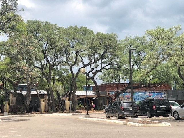
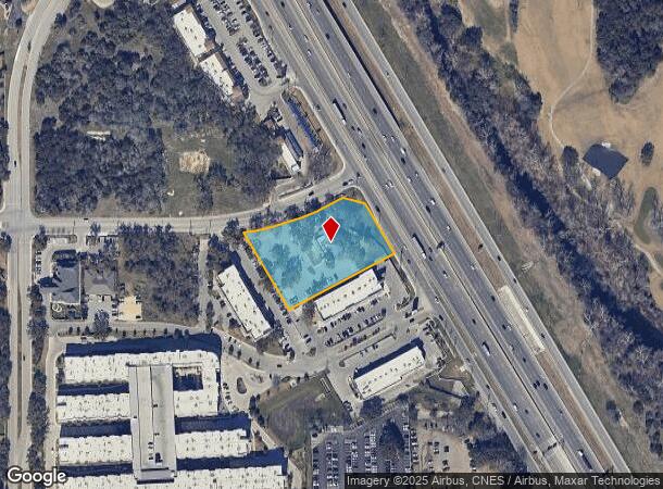
Property Record
21819 W Interstate 10, San Antonio, TX 78257

NEARBY LISTINGS FOR SALE OR LEASE
Property Detail
21819 W Interstate 10
San Antonio-New Braunfels, TX
Ncb 18335 (Dominion Crossing Ut-1)
18335-013-0010
NCB 18335 (DOMINION CROSSING UT-1), BLOCK 13 LOT 1 2015-NEW PER PLAT 9664/203-211 FILED 2-21-2014
Restaurantbuilding
Bexar
AE
Texas
48029C0115F
1
2024
2.07 AC
2025
Far Northwest
181902
San Antonio
5,188 SF
DEMOGRAPHICS near 21819 W Interstate 10
1 Mile
3 Mile
5 Mile
2024 Total Population
6,757
31,919
82,985
2029 Population
7,283
34,458
89,655
Pop Growth 2024-2029
+ 7.78%
+ 7.95%
+ 8.04%
Average Age
39
38
35
2024 Total Households
2,672
13,179
32,160
HH Growth 2024-2029
+ 8.12%
+ 8.24%
+ 8.38%
Median Household Inc
$108,288
$100,500
$92,894
Avg Household Size
2.50
2.40
2.50
2024 Avg HH Vehicles
2.00
2.00
2.00
Median Home Value
$555,147
$459,469
$418,200
Median Year Built
2010
2010
2010
Nearby Places
Map Layers
Map Styles
 Street
 Aerial
- Restaurants
- Banks
- Shops
- Fitness
- Groceries
PUBLIC TRANSPORTATION
AIRPORT
San Antonio International
DRIVE
WALK
Distance
San Antonio International
22 min
16.4 mi
SALE & LEASE HISTORY
LISTING DATE
SALE/LEASE

Feb 27, 2025
For Sale
Nearby Properties
Address
Land Use
TOTAL SIZE
Lot Size
Zoning
Address
Land Use
TOTAL SIZE
Lot Size
Zoning
23,242.10 AC
Address
Land Use
TOTAL SIZE
Lot Size
Zoning
405,133 SF
16.41 AC
Address
Land Use
TOTAL SIZE
Lot Size
Zoning
538,895 SF
54.58 AC
Address
Land Use
TOTAL SIZE
Lot Size
Zoning
538,895 SF
60.25 AC
Address
Land Use
TOTAL SIZE
Lot Size
Zoning
509,312 SF
43.63 AC
Address
Land Use
TOTAL SIZE
Lot Size
Zoning
384,503 SF
15.95 AC
Address
Land Use
TOTAL SIZE
Lot Size
Zoning
391,367 SF
11.36 AC
Address
Land Use
TOTAL SIZE
Lot Size
Zoning
481,373 SF
44.28 AC
Address
Land Use
TOTAL SIZE
Lot Size
Zoning
10,622 SF
8.01 AC
Address
Land Use
TOTAL SIZE
Lot Size
Zoning
375,702 SF
10 AC
Address
Land Use
TOTAL SIZE
Lot Size
Zoning
361,559 SF
20 AC
Address
Land Use
TOTAL SIZE
Lot Size
Zoning
329,035 SF
21.28 AC
Address
Land Use
TOTAL SIZE
Lot Size
Zoning
309,429 SF
5.17 AC
Address
Land Use
TOTAL SIZE
Lot Size
Zoning
331,741 SF
16.53 AC
Address
Land Use
TOTAL SIZE
Lot Size
Zoning
312,150 SF
22.60 AC
Address
Land Use
TOTAL SIZE
Lot Size
Zoning
260,620 SF
10.21 AC
Address
Land Use
TOTAL SIZE
Lot Size
Zoning
277,720 SF
16.97 AC
Address
Land Use
TOTAL SIZE
Lot Size
Zoning
272,094 SF
16.90 AC
Address
Land Use
TOTAL SIZE
Lot Size
Zoning
270,295 SF
14.07 AC
Address
Land Use
TOTAL SIZE
Lot Size
Zoning
269,056 SF
12.13 AC
Address
Land Use
TOTAL SIZE
Lot Size
Zoning
243,485 SF
9.34 AC
Address
Land Use
TOTAL SIZE
Lot Size
Zoning
319,253 SF
23.95 AC
Address
Land Use
TOTAL SIZE
Lot Size
Zoning
300,670 SF
15.37 AC
Address
Land Use
TOTAL SIZE
Lot Size
Zoning
146,208 SF
12.84 AC
Address
Land Use
TOTAL SIZE
Lot Size
Zoning
5,698 SF
10.50 AC
Address
Land Use
TOTAL SIZE
Lot Size
Zoning
196,272 SF
18.63 AC
Address
Land Use
TOTAL SIZE
Lot Size
Zoning
138,046 SF
14.23 AC
Address
Land Use
TOTAL SIZE
Lot Size
Zoning
317,851 SF
16.37 AC
Address
Land Use
TOTAL SIZE
Lot Size
Zoning
179,872 SF
12.59 AC
Address
Land Use
TOTAL SIZE
Lot Size
Zoning
208,654 SF
3.78 AC
The World's #1 Commercial Real Estate Marketplace
Connect with us
© 2025 CoStar Group
The information above has been obtained from sources believed reliable. While we do not doubt its accuracy we have not verified it and make no guarantee, warranty or representation about it. It is your responsibility to independently confirm its accuracy and completeness. Any projections, opinions, assumptions, or estimates used are for example only and do not represent the current or future performance of the property. The value of this transaction to you depends on tax and other factors which should be evaluated by your tax, financial, and legal advisors. You and your advisors should conduct a careful, independent investigation of the property to determine to your satisfaction the suitability of the property for your needs.