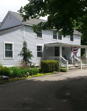
Property Record
2183 Matunuck Schoolhouse Rd, Charlestown, RI 02813
NEARBY LISTINGS FOR SALE OR LEASE
Property Detail
2183 Matunuck Schoolhouse Rd
CHAR-000013-000000-000096
Washington
Commercialofficeresidentialmixeduse
Rhode Island
X
96
44009C0188J
1.53 AC
2025
Washington County
2025
Providence
051102
Providence-Warwick, RI-MA
3,008 SF
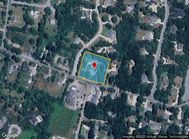
DEMOGRAPHICS near 2183 Matunuck Schoolhouse Rd
1 Mile
3 Mile
5 Mile
2024 Total Population
3,346
7,596
14,136
2029 Population
3,518
7,904
14,699
Pop Growth 2024-2029
+ 5.14%
+ 4.05%
+ 3.98%
Average Age
51
50
49
2024 Total Households
1,621
3,531
6,383
HH Growth 2024-2029
+ 4.94%
+ 4.02%
+ 4.09%
Median Household Inc
$86,210
$90,599
$95,823
Avg Household Size
2.10
2.10
2.20
2024 Avg HH Vehicles
2.00
2.00
2.00
Median Home Value
$464,622
$451,159
$459,683
Median Year Built
1978
1979
1978
Nearby Places
Map Layers
Map Styles
 Street
 Aerial
- Restaurants
- Banks
- Shops
- Fitness
- Groceries
PUBLIC TRANSPORTATION
AIRPORT
Rhode Island Tf Green International
DRIVE
WALK
Distance
Rhode Island Tf Green International
50 min
34.7 mi
Freight Ports
Port of Davisville, RI
DRIVE
WALK
Distance
Port of Davisville, RI
40 min
24.5 mi
Nearby Properties
Address
Land Use
TOTAL SIZE
Lot Size
Zoning
Address
Land Use
TOTAL SIZE
Lot Size
Zoning
Address
Land Use
TOTAL SIZE
Lot Size
Zoning
175 AC
M
Address
Land Use
TOTAL SIZE
Lot Size
Zoning
379.71 AC
OSR
Address
Land Use
TOTAL SIZE
Lot Size
Zoning
2,888 SF
4.23 AC
TVD
Address
Land Use
TOTAL SIZE
Lot Size
Zoning
1.48 AC
R40
Address
Land Use
TOTAL SIZE
Lot Size
Zoning
2.31 AC
R2A
Address
Land Use
TOTAL SIZE
Lot Size
Zoning
3.38 AC
RA
Address
Land Use
TOTAL SIZE
Lot Size
Zoning
806 SF
3.49 AC
R2A
Address
Land Use
TOTAL SIZE
Lot Size
Zoning
9,967 SF
9.48 AC
M
Address
Land Use
TOTAL SIZE
Lot Size
Zoning
362.70 AC
NITSL
Address
Land Use
TOTAL SIZE
Lot Size
Zoning
13.30 AC
M
Address
Land Use
TOTAL SIZE
Lot Size
Zoning
2.14 AC
R2A
Address
Land Use
TOTAL SIZE
Lot Size
Zoning
0.42 AC
R30
Address
Land Use
TOTAL SIZE
Lot Size
Zoning
3.91 AC
R2A
Address
Land Use
TOTAL SIZE
Lot Size
Zoning
0.49 AC
R2A
Address
Land Use
TOTAL SIZE
Lot Size
Zoning
2.50 AC
C2
Address
Land Use
TOTAL SIZE
Lot Size
Zoning
1.02 AC
R2A
Address
Land Use
TOTAL SIZE
Lot Size
Zoning
104.90 AC
R3A
Address
Land Use
TOTAL SIZE
Lot Size
Zoning
77.90 AC
R2A
Address
Land Use
TOTAL SIZE
Lot Size
Zoning
8.11 AC
OS
Address
Land Use
TOTAL SIZE
Lot Size
Zoning
2,224 SF
4.76 AC
R40
Address
Land Use
TOTAL SIZE
Lot Size
Zoning
1.88 AC
R2A
Address
Land Use
TOTAL SIZE
Lot Size
Zoning
225 AC
NITSL
Address
Land Use
TOTAL SIZE
Lot Size
Zoning
1,185 SF
13 AC
M
Address
Land Use
TOTAL SIZE
Lot Size
Zoning
4,493 SF
92 AC
R3A
Address
Land Use
TOTAL SIZE
Lot Size
Zoning
9,570 SF
2.01 AC
TVD
Address
Land Use
TOTAL SIZE
Lot Size
Zoning
178.79 AC
R2A
Address
Land Use
TOTAL SIZE
Lot Size
Zoning
1.84 AC
R2A
Address
Land Use
TOTAL SIZE
Lot Size
Zoning
3.32 AC
RA
Address
Land Use
TOTAL SIZE
Lot Size
Zoning
3.69 AC
RA
The World's #1 Commercial Real Estate Marketplace
Connect with us
© 2025 CoStar Group
The information above has been obtained from sources believed reliable. While we do not doubt its accuracy we have not verified it and make no guarantee, warranty or representation about it. It is your responsibility to independently confirm its accuracy and completeness. Any projections, opinions, assumptions, or estimates used are for example only and do not represent the current or future performance of the property. The value of this transaction to you depends on tax and other factors which should be evaluated by your tax, financial, and legal advisors. You and your advisors should conduct a careful, independent investigation of the property to determine to your satisfaction the suitability of the property for your needs.