Property Record
2183 Vista Way, Oceanside, CA 92054

Save to a Folder
{{folder.Name}}
{{folder.ListingIds.length}} Properties
{{folder.ListingIds.length}} Property
Create a New Folder
Property Detail
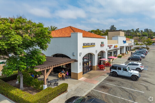
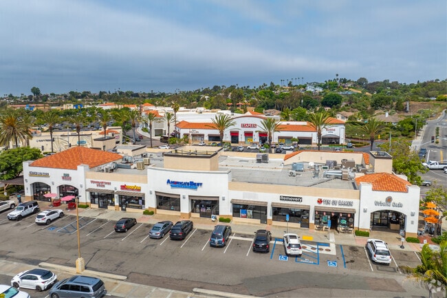
2183 Vista Way
154-130-36
PAR 14 TR PM17735
Stripcommercialcenter
San Diego
CS-HO
California
B and X Area of moderate flood hazard, usually the area between the limits of the 100-year and 500-year floods.
1.43 AC
2024
Oceanside
2025
San Diego
018504
San Diego-Chula Vista-Carlsbad, CA
15,000 SF
NEARBY LISTINGS FOR SALE OR LEASE
DEMOGRAPHICS near 2183 Vista Way
1 mile
3 mile
5 mile
2025 Total Population
9,711
106,616
224,878
2030 Population
9,691
107,938
226,741
Pop Growth 2025-2030
(0.21%)
+ 1.24%
+ 0.83%
Average Age
42
42
40
2025 Total Households
3,783
43,145
82,173
HH Growth 2025-2030
(0.37%)
+ 1.34%
+ 0.92%
Median Household Inc
$98,637
$93,940
$96,102
Avg Household Size
2.50
2.40
2.60
2025 Avg HH Vehicles
2.00
2.00
2.00
Median Home Value
$1,063,602
$922,588
$816,455
Median Year Built
1975
1979
1983
Nearby Places
Map Layers
Map Styles
 Street
 Aerial
Layers
 Traffic
 Biking
Places
Listings with unknown addresses are not visible on the map
- Restaurants
- Banks
- Shops
- Fitness
- Groceries
PUBLIC TRANSPORTATION
COMMUTER RAIL
Carlsbad Village (Coaster - San Diego North County Transit District (Coaster/Sprinter/Breeze))
Drive
Walk
Distance
Carlsbad Village (Coaster - San Diego North County Transit District (Coaster/Sprinter/Breeze))
7 min
2.6 mi
Oceanside Transit Center (Orange County Line - Southern California Regional Rail Authority (Metrolink))
Drive
Walk
Distance
Oceanside Transit Center (Orange County Line - Southern California Regional Rail Authority (Metrolink))
9 min
4.3 mi
AIRPORT
San Diego International
Drive
Walk
Distance
San Diego International
44 min
34.3 mi
SALE & LEASE HISTORY
LISTING DATE
SALE/LEASE

Sep 25, 2016
For Lease
May 07, 2021
For Lease
Mar 30, 2017
For Lease
Mar 21, 2019
For Sale
Nearby Properties
Address
Land Use
TOTAL SIZE
Lot Size
Zoning
Address
Land Use
TOTAL SIZE
Lot Size
Zoning
1.38 AC
C
Address
Land Use
TOTAL SIZE
Lot Size
Zoning
15.74 AC
SP-1-84 (I
Address
Land Use
TOTAL SIZE
Lot Size
Zoning
15.25 AC
P-C
Address
Land Use
TOTAL SIZE
Lot Size
Zoning
9,999 SF
5.28 AC
C2
Address
Land Use
TOTAL SIZE
Lot Size
Zoning
16 AC
P-C
Address
Land Use
TOTAL SIZE
Lot Size
Zoning
1.38 AC
C
Address
Land Use
TOTAL SIZE
Lot Size
Zoning
12 AC
SP-1-09
Address
Land Use
TOTAL SIZE
Lot Size
Zoning
9.65 AC
P-C
Address
Land Use
TOTAL SIZE
Lot Size
Zoning
4.26 AC
C-2
Address
Land Use
TOTAL SIZE
Lot Size
Zoning
1.77 AC
C-2
Address
Land Use
TOTAL SIZE
Lot Size
Zoning
1.14 AC
C
Address
Land Use
TOTAL SIZE
Lot Size
Zoning
96,240 SF
22.25 AC
PD-2
Address
Land Use
TOTAL SIZE
Lot Size
Zoning
85,000 SF
4.40 AC
CC
Address
Land Use
TOTAL SIZE
Lot Size
Zoning
9,999 SF
5.24 AC
SP-1-09
Address
Land Use
TOTAL SIZE
Lot Size
Zoning
19.51 AC
C-2-Q
Address
Land Use
TOTAL SIZE
Lot Size
Zoning
10.63 AC
RD-M
Address
Land Use
TOTAL SIZE
Lot Size
Zoning
1.02 AC
D-1
Address
Land Use
TOTAL SIZE
Lot Size
Zoning
2.30 AC
V-R
Address
Land Use
TOTAL SIZE
Lot Size
Zoning
95,418 SF
6.51 AC
P-C
Address
Land Use
TOTAL SIZE
Lot Size
Zoning
15.02 AC
SP-1-84 (I
Address
Land Use
TOTAL SIZE
Lot Size
Zoning
25.16 AC
SP-1-84 (I
Address
Land Use
TOTAL SIZE
Lot Size
Zoning
87,472 SF
4.96 AC
RM-A
Address
Land Use
TOTAL SIZE
Lot Size
Zoning
6.63 AC
RD-M
Address
Land Use
TOTAL SIZE
Lot Size
Zoning
78,489 SF
2.67 AC
PD-1 (IL)
Address
Land Use
TOTAL SIZE
Lot Size
Zoning
57,905 SF
2.16 AC
R-3
Address
Land Use
TOTAL SIZE
Lot Size
Zoning
83,995 SF
5.88 AC
PD-1 (IL)
Address
Land Use
TOTAL SIZE
Lot Size
Zoning
15.81 AC
SP-1-84 (I
Address
Land Use
TOTAL SIZE
Lot Size
Zoning
1.34 AC
V-B
Address
Land Use
TOTAL SIZE
Lot Size
Zoning
58,256 SF
5.67 AC
RM-A
Address
Land Use
TOTAL SIZE
Lot Size
Zoning
64,722 SF
2.17 AC
D-1
The World's #1 Commercial Real Estate Marketplace
Connect with us
© 2026 CoStar Group
The information above has been obtained from sources believed reliable. While we do not doubt its accuracy we have not verified it and make no guarantee, warranty or representation about it. It is your responsibility to independently confirm its accuracy and completeness. Any projections, opinions, assumptions, or estimates used are for example only and do not represent the current or future performance of the property. The value of this transaction to you depends on tax and other factors which should be evaluated by your tax, financial, and legal advisors. You and your advisors should conduct a careful, independent investigation of the property to determine to your satisfaction the suitability of the property for your needs.