Property Record
2183 W Main St, Lehi, UT 84043
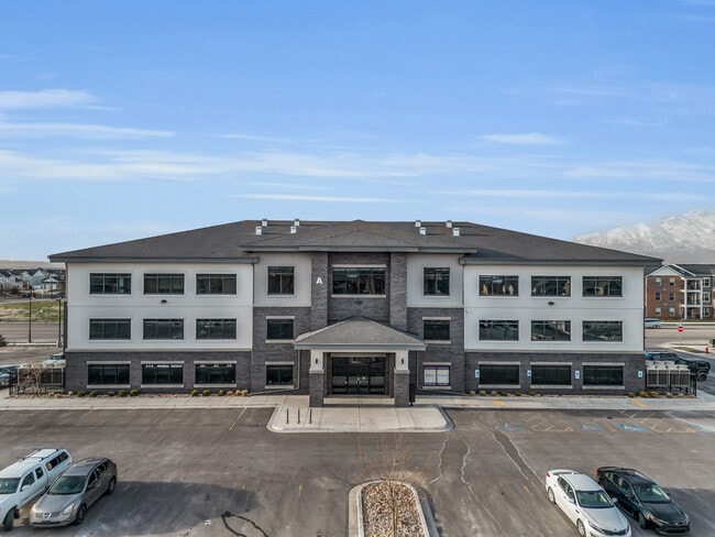
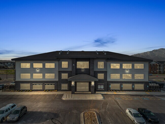

This Property Is For Sale
Property Detail
2183 W Main St
Provo-Orem-Lehi, UT
UNIT A305, GRAY FARMS OFFICE CONDOS. AREA 0.068 AC.
40-537-0010
Utah
Officebuilding
Utah
2024
0.07 AC
2025
Utah County
010127
Salt Lake City
2,975 SF
NEARBY LISTINGS FOR SALE OR LEASE
DEMOGRAPHICS near 2183 W Main St
1 mile
3 mile
5 mile
2025 Total Population
10,149
87,721
181,653
2030 Population
11,254
98,332
202,990
Pop Growth 2025-2030
+ 10.89%
+ 12.10%
+ 11.75%
Average Age
29
30
30
2025 Total Households
2,521
23,933
48,332
HH Growth 2025-2030
+ 11.66%
+ 12.76%
+ 12.50%
Median Household Inc
$140,580
$124,481
$124,787
Avg Household Size
4.10
3.70
3.80
2025 Avg HH Vehicles
3.00
2.00
2.00
Median Home Value
$702,783
$648,127
$661,384
Median Year Built
2010
2010
2010
Nearby Places
Map Layers
Map Styles
 Street
 Aerial
Layers
 Traffic
 Biking
Places
Listings with unknown addresses are not visible on the map
- Restaurants
- Banks
- Shops
- Fitness
- Groceries
PUBLIC TRANSPORTATION
COMMUTER RAIL
Lehi Station (FrontRunner - Utah Transit Authority (UTA))
Drive
Walk
Distance
Lehi Station (FrontRunner - Utah Transit Authority (UTA))
8 min
2.9 mi
American Fork Station (FrontRunner - Utah Transit Authority (UTA))
Drive
Walk
Distance
American Fork Station (FrontRunner - Utah Transit Authority (UTA))
10 min
4.9 mi
AIRPORT
Provo Municipal
Drive
Walk
Distance
Provo Municipal
27 min
19.8 mi
Salt Lake City International
Drive
Walk
Distance
Salt Lake City International
41 min
32.5 mi
Freight Ports
Port of Stockton
Drive
Walk
Distance
Port of Stockton
742 min
722.9 mi
Nearby Properties
Address
Land Use
TOTAL SIZE
Lot Size
Zoning
Address
Land Use
TOTAL SIZE
Lot Size
Zoning
264,805 SF
16.20 AC
Address
Land Use
TOTAL SIZE
Lot Size
Zoning
130,480 SF
27.19 AC
Address
Land Use
TOTAL SIZE
Lot Size
Zoning
36.17 AC
Address
Land Use
TOTAL SIZE
Lot Size
Zoning
130,480 SF
25.12 AC
Address
Land Use
TOTAL SIZE
Lot Size
Zoning
376,499 SF
5.22 AC
Address
Land Use
TOTAL SIZE
Lot Size
Zoning
166,233 SF
8.70 AC
Address
Land Use
TOTAL SIZE
Lot Size
Zoning
359,445 SF
6.46 AC
Address
Land Use
TOTAL SIZE
Lot Size
Zoning
131,961 SF
7.57 AC
Address
Land Use
TOTAL SIZE
Lot Size
Zoning
216,478 SF
7.38 AC
Address
Land Use
TOTAL SIZE
Lot Size
Zoning
255,672 SF
6.21 AC
Address
Land Use
TOTAL SIZE
Lot Size
Zoning
215,516 SF
4.93 AC
Address
Land Use
TOTAL SIZE
Lot Size
Zoning
181,908 SF
1.43 AC
Address
Land Use
TOTAL SIZE
Lot Size
Zoning
147,368 SF
6.91 AC
Address
Land Use
TOTAL SIZE
Lot Size
Zoning
304,991 SF
7.05 AC
Address
Land Use
TOTAL SIZE
Lot Size
Zoning
139,088 SF
9.14 AC
Address
Land Use
TOTAL SIZE
Lot Size
Zoning
149,591 SF
7.07 AC
Address
Land Use
TOTAL SIZE
Lot Size
Zoning
253,421 SF
7.36 AC
Address
Land Use
TOTAL SIZE
Lot Size
Zoning
293,170 SF
9.60 AC
Address
Land Use
TOTAL SIZE
Lot Size
Zoning
255,672 SF
2.94 AC
Address
Land Use
TOTAL SIZE
Lot Size
Zoning
9.80 AC
Address
Land Use
TOTAL SIZE
Lot Size
Zoning
266,041 SF
11.28 AC
Address
Land Use
TOTAL SIZE
Lot Size
Zoning
142,042 SF
6.99 AC
Address
Land Use
TOTAL SIZE
Lot Size
Zoning
142,299 SF
6.99 AC
Address
Land Use
TOTAL SIZE
Lot Size
Zoning
150,068 SF
5.05 AC
Address
Land Use
TOTAL SIZE
Lot Size
Zoning
143,199 SF
5.83 AC
Address
Land Use
TOTAL SIZE
Lot Size
Zoning
146,675 SF
1.09 AC
Address
Land Use
TOTAL SIZE
Lot Size
Zoning
61,537 SF
3 AC
Address
Land Use
TOTAL SIZE
Lot Size
Zoning
98,726 SF
2.85 AC
Address
Land Use
TOTAL SIZE
Lot Size
Zoning
198,068 SF
20.72 AC
Address
Land Use
TOTAL SIZE
Lot Size
Zoning
123,381 SF
12.30 AC
The World's #1 Commercial Real Estate Marketplace
Connect with us
© 2026 CoStar Group
The information above has been obtained from sources believed reliable. While we do not doubt its accuracy we have not verified it and make no guarantee, warranty or representation about it. It is your responsibility to independently confirm its accuracy and completeness. Any projections, opinions, assumptions, or estimates used are for example only and do not represent the current or future performance of the property. The value of this transaction to you depends on tax and other factors which should be evaluated by your tax, financial, and legal advisors. You and your advisors should conduct a careful, independent investigation of the property to determine to your satisfaction the suitability of the property for your needs.