Property Record
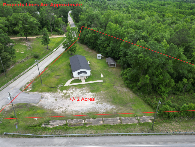
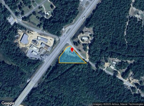
Highway 29, Flomaton, AL 36441
This Property Is For Sale
NEARBY LISTINGS FOR SALE OR LEASE
-
-
View all Flomaton listings for sale on LoopNet.com
Property Detail
Highway 29
24-08-28-4-005-002.000
ALL SE1 4 OF SE1 4 OF SEC 28 T 1N R8E LYING S OF US RT 31 & W OF LOWER CREEK RD FLOMATON
Religious
Escambia
X
Alabama
01053C0444E
2 AC
0
Alabama South Area
2024
Other Market Areas
970300
Atmore, AL
1,769 SF
DEMOGRAPHICS near Highway 29
1 Mile
3 Mile
5 Mile
2024 Total Population
912
3,619
7,183
2029 Population
908
3,687
7,348
Pop Growth 2024-2029
(0.44%)
+ 1.88%
+ 2.30%
Average Age
41
41
41
2024 Total Households
366
1,456
2,540
HH Growth 2024-2029
(0.27%)
+ 1.99%
+ 2.28%
Median Household Inc
$44,852
$44,921
$44,073
Avg Household Size
2.50
2.50
2.50
2024 Avg HH Vehicles
2.00
2.00
2.00
Median Home Value
$160,112
$138,291
$149,248
Median Year Built
1986
1987
1987
Nearby Places
Map Layers
Map Styles
 Street
 Aerial
- Restaurants
- Banks
- Shops
- Fitness
- Groceries
Nearby Properties
Address
Land Use
TOTAL SIZE
Lot Size
Zoning
Address
Land Use
TOTAL SIZE
Lot Size
Zoning
34,538 SF
7.66 AC
INCORP
Address
Land Use
TOTAL SIZE
Lot Size
Zoning
83,668 SF
22.44 AC
INCORP
Address
Land Use
TOTAL SIZE
Lot Size
Zoning
27,844 SF
10 AC
INCORP
Address
Land Use
TOTAL SIZE
Lot Size
Zoning
38,000 SF
4.97 AC
INCORP
Address
Land Use
TOTAL SIZE
Lot Size
Zoning
7,795 SF
2.18 AC
INCORP
Address
Land Use
TOTAL SIZE
Lot Size
Zoning
4,591 SF
36.24 AC
RR
Address
Land Use
TOTAL SIZE
Lot Size
Zoning
26,362 SF
2.76 AC
INCORP
Address
Land Use
TOTAL SIZE
Lot Size
Zoning
28,667 SF
6.88 AC
INCORP
Address
Land Use
TOTAL SIZE
Lot Size
Zoning
27,430 SF
7.34 AC
INCORP
Address
Land Use
TOTAL SIZE
Lot Size
Zoning
9,230 SF
0.73 AC
INCORP
Address
Land Use
TOTAL SIZE
Lot Size
Zoning
22,654 SF
2 AC
INCORP
Address
Land Use
TOTAL SIZE
Lot Size
Zoning
8,500 SF
1.45 AC
INCORP
Address
Land Use
TOTAL SIZE
Lot Size
Zoning
8,000 SF
0.34 AC
INCORP
Address
Land Use
TOTAL SIZE
Lot Size
Zoning
4,435 SF
1.60 AC
INCORP
Address
Land Use
TOTAL SIZE
Lot Size
Zoning
12,733 SF
1 AC
INCORP
Address
Land Use
TOTAL SIZE
Lot Size
Zoning
3,051 SF
2.98 AC
INCORP
Address
Land Use
TOTAL SIZE
Lot Size
Zoning
18,668 SF
0.59 AC
Address
Land Use
TOTAL SIZE
Lot Size
Zoning
10,820 SF
1.11 AC
INCORP
Address
Land Use
TOTAL SIZE
Lot Size
Zoning
8,027 SF
24.01 AC
RR
Address
Land Use
TOTAL SIZE
Lot Size
Zoning
11,600 SF
1.11 AC
INCORP
Address
Land Use
TOTAL SIZE
Lot Size
Zoning
12,542 SF
3.92 AC
INCORP
Address
Land Use
TOTAL SIZE
Lot Size
Zoning
3,143 SF
0.96 AC
INCORP
Address
Land Use
TOTAL SIZE
Lot Size
Zoning
8,150 SF
0.62 AC
RMU
Address
Land Use
TOTAL SIZE
Lot Size
Zoning
3,606 SF
3.62 AC
INCORP
Address
Land Use
TOTAL SIZE
Lot Size
Zoning
4,200 SF
2.43 AC
INCORP
Address
Land Use
TOTAL SIZE
Lot Size
Zoning
1,333 SF
157.70 AC
RMU
Address
Land Use
TOTAL SIZE
Lot Size
Zoning
4,376 SF
119 AC
RR
Address
Land Use
TOTAL SIZE
Lot Size
Zoning
10,700 SF
2.13 AC
INCORP
Address
Land Use
TOTAL SIZE
Lot Size
Zoning
4,115 SF
0.68 AC
INCORP
Address
Land Use
TOTAL SIZE
Lot Size
Zoning
3,264 SF
8 AC
The World's #1 Commercial Real Estate Marketplace
Connect with us
© 2025 CoStar Group
The information above has been obtained from sources believed reliable. While we do not doubt its accuracy we have not verified it and make no guarantee, warranty or representation about it. It is your responsibility to independently confirm its accuracy and completeness. Any projections, opinions, assumptions, or estimates used are for example only and do not represent the current or future performance of the property. The value of this transaction to you depends on tax and other factors which should be evaluated by your tax, financial, and legal advisors. You and your advisors should conduct a careful, independent investigation of the property to determine to your satisfaction the suitability of the property for your needs.