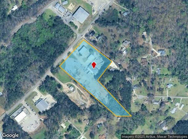
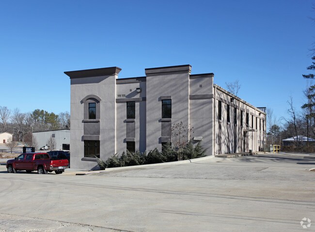
Property Record
2185 Alton Rd, Birmingham, AL 35210

NEARBY LISTINGS FOR SALE OR LEASE
Property Detail
2185 Alton Rd
Birmingham-Hoover, AL
I.I.Cs Add Irondale 24-9
24-00-09-4-001-005.000
LOT 1 IICS ADD TO IRONDALE PB 216 PG 72
Commercialnec
Jefferson
X
Alabama
01073C0409H
1
2023
5 AC
2024
Trussville
012602
Birmingham
14,414 SF
DEMOGRAPHICS near 2185 Alton Rd
1 Mile
3 Mile
5 Mile
2024 Total Population
1,105
13,206
71,832
2029 Population
1,084
12,872
70,534
Pop Growth 2024-2029
(1.90%)
(2.53%)
(1.81%)
Average Age
40
41
39
2024 Total Households
411
5,196
27,815
HH Growth 2024-2029
(1.95%)
(2.71%)
(1.89%)
Median Household Inc
$42,395
$64,173
$55,500
Avg Household Size
2.50
2.40
2.40
2024 Avg HH Vehicles
2.00
2.00
2.00
Median Home Value
$190,082
$185,275
$172,001
Median Year Built
1976
1977
1973
Nearby Places
Map Layers
Map Styles
 Street
 Aerial
- Restaurants
- Banks
- Shops
- Fitness
- Groceries
PUBLIC TRANSPORTATION
AIRPORT
Birmingham-Shuttlesworth International
DRIVE
WALK
Distance
Birmingham-Shuttlesworth International
17 min
9.5 mi
Nearby Properties
Address
Land Use
TOTAL SIZE
Lot Size
Zoning
Address
Land Use
TOTAL SIZE
Lot Size
Zoning
152,664 SF
12.44 AC
CO&I
Address
Land Use
TOTAL SIZE
Lot Size
Zoning
326,294 SF
25.99 AC
R4&U
Address
Land Use
TOTAL SIZE
Lot Size
Zoning
174,247 SF
46.70 AC
INST
Address
Land Use
TOTAL SIZE
Lot Size
Zoning
356,967 SF
34.71 AC
I3S&
Address
Land Use
TOTAL SIZE
Lot Size
Zoning
146,331 SF
161 AC
I3S&
Address
Land Use
TOTAL SIZE
Lot Size
Zoning
128,233 SF
CO&I
Address
Land Use
TOTAL SIZE
Lot Size
Zoning
155,845 SF
17 AC
C2
Address
Land Use
TOTAL SIZE
Lot Size
Zoning
137,168 SF
63 AC
A1
Address
Land Use
TOTAL SIZE
Lot Size
Zoning
168,744 SF
8.46 AC
I1
Address
Land Use
TOTAL SIZE
Lot Size
Zoning
94,262 SF
17.30 AC
C-2
Address
Land Use
TOTAL SIZE
Lot Size
Zoning
58,509 SF
CO&I
Address
Land Use
TOTAL SIZE
Lot Size
Zoning
39,890 SF
7.10 AC
R8
Address
Land Use
TOTAL SIZE
Lot Size
Zoning
57,296 SF
CO&I
Address
Land Use
TOTAL SIZE
Lot Size
Zoning
178,988 SF
8.29 AC
CR5
Address
Land Use
TOTAL SIZE
Lot Size
Zoning
194,730 SF
25 AC
I-1
Address
Land Use
TOTAL SIZE
Lot Size
Zoning
113,014 SF
8 AC
I1
Address
Land Use
TOTAL SIZE
Lot Size
Zoning
47,720 SF
5.21 AC
QB2
Address
Land Use
TOTAL SIZE
Lot Size
Zoning
149,773 SF
7.30 AC
CR5
Address
Land Use
TOTAL SIZE
Lot Size
Zoning
176,232 SF
5.20 AC
C2
Address
Land Use
TOTAL SIZE
Lot Size
Zoning
110,776 SF
11.10 AC
C2
Address
Land Use
TOTAL SIZE
Lot Size
Zoning
64,859 SF
105 AC
INST
Address
Land Use
TOTAL SIZE
Lot Size
Zoning
97,021 SF
17.50 AC
R1
Address
Land Use
TOTAL SIZE
Lot Size
Zoning
53,864 SF
6.58 AC
C2
Address
Land Use
TOTAL SIZE
Lot Size
Zoning
49,858 SF
7.30 AC
C4
Address
Land Use
TOTAL SIZE
Lot Size
Zoning
97,652 SF
6.20 AC
C2
Address
Land Use
TOTAL SIZE
Lot Size
Zoning
170,992 SF
10 AC
C1
Address
Land Use
TOTAL SIZE
Lot Size
Zoning
122,397 SF
13.13 AC
C1
Address
Land Use
TOTAL SIZE
Lot Size
Zoning
40,011 SF
2.05 AC
C1
Address
Land Use
TOTAL SIZE
Lot Size
Zoning
76,037 SF
32.40 AC
A1
Address
Land Use
TOTAL SIZE
Lot Size
Zoning
101,606 SF
4.46 AC
C-2
The World's #1 Commercial Real Estate Marketplace
Connect with us
© 2025 CoStar Group
The information above has been obtained from sources believed reliable. While we do not doubt its accuracy we have not verified it and make no guarantee, warranty or representation about it. It is your responsibility to independently confirm its accuracy and completeness. Any projections, opinions, assumptions, or estimates used are for example only and do not represent the current or future performance of the property. The value of this transaction to you depends on tax and other factors which should be evaluated by your tax, financial, and legal advisors. You and your advisors should conduct a careful, independent investigation of the property to determine to your satisfaction the suitability of the property for your needs.