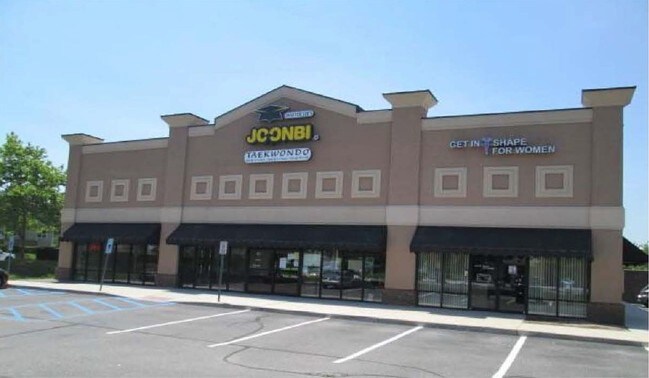
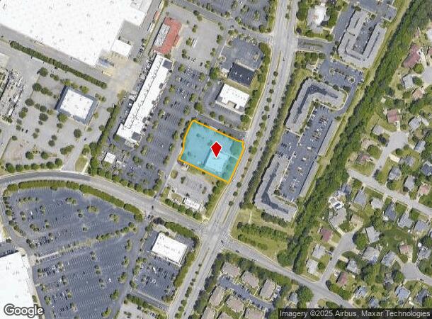
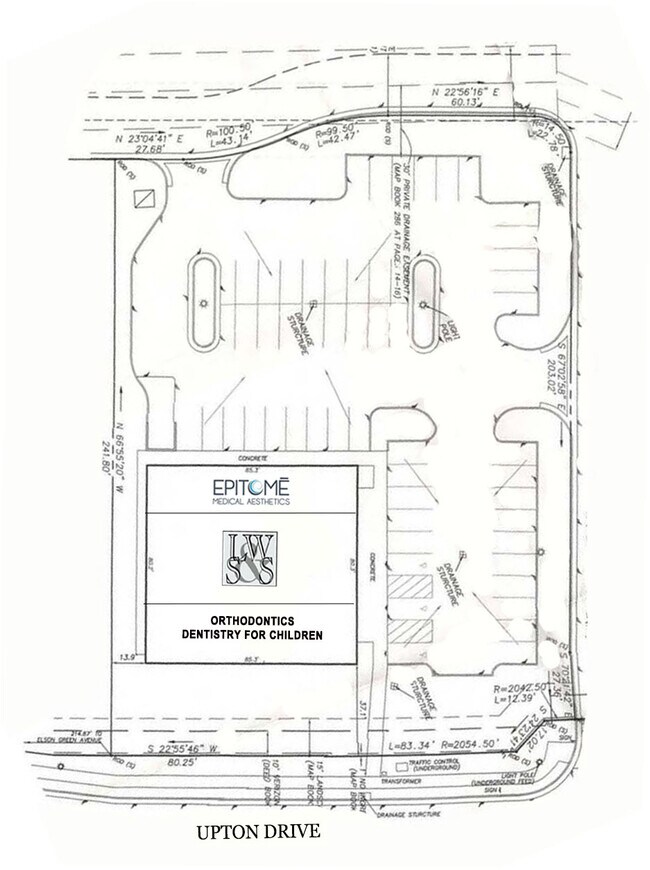
Property Record
2185 Upton Dr, Virginia Beach, VA 23454
NEARBY LISTINGS FOR SALE OR LEASE
Property Detail
2185 Upton Dr
Virginia Beach-Norfolk-Newport News, VA-NC
Red Mill Commons
2414-34-1779
SUBD OF PARCEL D-8-1 AT RED MILL COMMONS PAR D-8-B 1.070 AC
Supermarket
Virginia Beach
X
Virginia
5155310119G
d8b
2024
1.07 AC
2025
General Booth Corr
045420
Hampton Roads
6,800 SF
DEMOGRAPHICS near 2185 Upton Dr
1 Mile
3 Mile
5 Mile
2024 Total Population
9,546
44,631
74,914
2029 Population
9,397
44,014
74,370
Pop Growth 2024-2029
(1.56%)
(1.38%)
(0.73%)
Average Age
40
39
39
2024 Total Households
3,259
15,652
25,624
HH Growth 2024-2029
(1.75%)
(1.48%)
(0.72%)
Median Household Inc
$116,784
$107,889
$106,025
Avg Household Size
2.90
2.80
2.80
2024 Avg HH Vehicles
2.00
2.00
2.00
Median Home Value
$420,775
$391,529
$392,420
Median Year Built
1991
1989
1990
Nearby Places
Map Layers
Map Styles
 Street
 Aerial
- Restaurants
- Banks
- Shops
- Fitness
- Groceries
PUBLIC TRANSPORTATION
AIRPORT
Norfolk International
DRIVE
WALK
Distance
Norfolk International
34 min
20.4 mi
SALE & LEASE HISTORY
LISTING DATE
SALE/LEASE

Sep 12, 2017
For Lease
Feb 28, 2024
For Sale
Nearby Properties
Address
Land Use
TOTAL SIZE
Lot Size
Zoning
Address
Land Use
TOTAL SIZE
Lot Size
Zoning
2,088 SF
44 SF
AG1
Address
Land Use
TOTAL SIZE
Lot Size
Zoning
675,493 SF
33.56 AC
AG1
Address
Land Use
TOTAL SIZE
Lot Size
Zoning
17,551 SF
68.66 AC
AG1
Address
Land Use
TOTAL SIZE
Lot Size
Zoning
249,927 SF
23.95 AC
B2
Address
Land Use
TOTAL SIZE
Lot Size
Zoning
303,706 SF
13.62 AC
AG2
Address
Land Use
TOTAL SIZE
Lot Size
Zoning
409,152 SF
29.42 AC
I2
Address
Land Use
TOTAL SIZE
Lot Size
Zoning
2 SF
29.96 AC
A12
Address
Land Use
TOTAL SIZE
Lot Size
Zoning
3 SF
15.73 AC
A18
Address
Land Use
TOTAL SIZE
Lot Size
Zoning
342,735 SF
49.62 AC
PDH2
Address
Land Use
TOTAL SIZE
Lot Size
Zoning
219,000 SF
75.18 AC
I1
Address
Land Use
TOTAL SIZE
Lot Size
Zoning
186,971 SF
23.87 AC
O2
Address
Land Use
TOTAL SIZE
Lot Size
Zoning
229,042 SF
36.70 AC
AG1
Address
Land Use
TOTAL SIZE
Lot Size
Zoning
253,540 SF
38.45 AC
I1
Address
Land Use
TOTAL SIZE
Lot Size
Zoning
5.88 AC
B4
Address
Land Use
TOTAL SIZE
Lot Size
Zoning
147,757 SF
15.74 AC
B2
Address
Land Use
TOTAL SIZE
Lot Size
Zoning
7,966 SF
52.53 AC
AG2
Address
Land Use
TOTAL SIZE
Lot Size
Zoning
112,724 SF
15.79 AC
R20
Address
Land Use
TOTAL SIZE
Lot Size
Zoning
203,385 SF
18.51 AC
B2
Address
Land Use
TOTAL SIZE
Lot Size
Zoning
188,679 SF
32.41 AC
AG1
Address
Land Use
TOTAL SIZE
Lot Size
Zoning
97,943 SF
11.92 AC
B2
Address
Land Use
TOTAL SIZE
Lot Size
Zoning
137,390 SF
AG2
Address
Land Use
TOTAL SIZE
Lot Size
Zoning
85,953 SF
13.19 AC
B2
Address
Land Use
TOTAL SIZE
Lot Size
Zoning
1 SF
218.01 AC
AG1
Address
Land Use
TOTAL SIZE
Lot Size
Zoning
112,843 SF
6.21 AC
O2
Address
Land Use
TOTAL SIZE
Lot Size
Zoning
87,332 SF
19.62 AC
I2
Address
Land Use
TOTAL SIZE
Lot Size
Zoning
71,031 SF
11.29 AC
R20
Address
Land Use
TOTAL SIZE
Lot Size
Zoning
88,596 SF
15.05 AC
AG1
Address
Land Use
TOTAL SIZE
Lot Size
Zoning
60,954 SF
123.90 AC
I2
Address
Land Use
TOTAL SIZE
Lot Size
Zoning
126,572 SF
0.01 AC
B2
Address
Land Use
TOTAL SIZE
Lot Size
Zoning
68,162 SF
6.57 AC
B2
The World's #1 Commercial Real Estate Marketplace
Connect with us
© 2025 CoStar Group
The information above has been obtained from sources believed reliable. While we do not doubt its accuracy we have not verified it and make no guarantee, warranty or representation about it. It is your responsibility to independently confirm its accuracy and completeness. Any projections, opinions, assumptions, or estimates used are for example only and do not represent the current or future performance of the property. The value of this transaction to you depends on tax and other factors which should be evaluated by your tax, financial, and legal advisors. You and your advisors should conduct a careful, independent investigation of the property to determine to your satisfaction the suitability of the property for your needs.