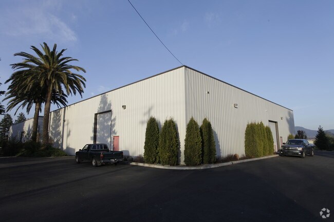
Property Record
21885 8Th St E, Sonoma, CA 95476


Save to a Folder
{{folder.Name}}
{{folder.ListingIds.length}} Properties
{{folder.ListingIds.length}} Property
Create a New Folder
Property Detail
21885 8Th St E
128-381-028
85 FM 128-381-24 CW PT 23 LLA 8194
Lightindustrial
Sonoma
MP
California
B and X Area of moderate flood hazard, usually the area between the limits of the 100-year and 500-year floods.
1
2025
3.15 AC
2025
Sonoma/Wine Country
150100
North Bay/Santa Rosa
8,750 SF
Santa Rosa-Petaluma, CA
NEARBY LISTINGS FOR SALE OR LEASE
DEMOGRAPHICS near 21885 8Th St E
1 mile
3 mile
5 mile
2025 Total Population
356
13,604
30,274
2030 Population
341
13,709
30,307
Pop Growth 2025-2030
(4.21%)
+ 0.77%
+ 0.11%
Average Age
50
53
48
2025 Total Households
147
6,508
13,152
HH Growth 2025-2030
(4.76%)
+ 0.86%
+ 0.17%
Median Household Inc
$138,235
$107,264
$109,505
Avg Household Size
2.30
2.10
2.30
2025 Avg HH Vehicles
2.00
2.00
2.00
Median Home Value
$1,073,913
$980,744
$869,139
Median Year Built
1966
1976
1976
Nearby Places
Map Layers
Map Styles
 Street
 Aerial
Layers
 Traffic
 Biking
Places
Listings with unknown addresses are not visible on the map
- Restaurants
- Banks
- Shops
- Fitness
- Groceries
PUBLIC TRANSPORTATION
AIRPORT
Charles M Schulz - Sonoma County
Drive
Walk
Distance
Charles M Schulz - Sonoma County
53 min
37.6 mi
Freight Ports
Port of Richmond
Drive
Walk
Distance
Port of Richmond
52 min
36.0 mi
Nearby Properties
Address
Land Use
TOTAL SIZE
Lot Size
Zoning
Address
Land Use
TOTAL SIZE
Lot Size
Zoning
2,859 SF
5.08 AC
Address
Land Use
TOTAL SIZE
Lot Size
Zoning
146,481 SF
9.20 AC
Address
Land Use
TOTAL SIZE
Lot Size
Zoning
49,586 SF
5.83 AC
Address
Land Use
TOTAL SIZE
Lot Size
Zoning
131,876 SF
5.46 AC
R3
Address
Land Use
TOTAL SIZE
Lot Size
Zoning
41.46 AC
DA20
Address
Land Use
TOTAL SIZE
Lot Size
Zoning
249,904 SF
16.23 AC
Address
Land Use
TOTAL SIZE
Lot Size
Zoning
84,545 SF
5.57 AC
Address
Land Use
TOTAL SIZE
Lot Size
Zoning
47,318 SF
4.63 AC
Address
Land Use
TOTAL SIZE
Lot Size
Zoning
59,651 SF
3.28 AC
RR3
Address
Land Use
TOTAL SIZE
Lot Size
Zoning
228,000 SF
11.27 AC
Address
Land Use
TOTAL SIZE
Lot Size
Zoning
3,734 SF
123.44 AC
Address
Land Use
TOTAL SIZE
Lot Size
Zoning
234,600 SF
12.01 AC
Address
Land Use
TOTAL SIZE
Lot Size
Zoning
73,920 SF
16.85 AC
Address
Land Use
TOTAL SIZE
Lot Size
Zoning
6,480 SF
8.87 AC
Address
Land Use
TOTAL SIZE
Lot Size
Zoning
79,759 SF
4.81 AC
Address
Land Use
TOTAL SIZE
Lot Size
Zoning
4,569 SF
15.84 AC
Address
Land Use
TOTAL SIZE
Lot Size
Zoning
8,626 SF
18.84 AC
DA10
Address
Land Use
TOTAL SIZE
Lot Size
Zoning
134,500 SF
7.94 AC
Address
Land Use
TOTAL SIZE
Lot Size
Zoning
96,820 SF
6.29 AC
Address
Land Use
TOTAL SIZE
Lot Size
Zoning
291,760 SF
16.98 AC
Address
Land Use
TOTAL SIZE
Lot Size
Zoning
7,118 SF
1.52 AC
Address
Land Use
TOTAL SIZE
Lot Size
Zoning
33,986 SF
2.07 AC
R2H
Address
Land Use
TOTAL SIZE
Lot Size
Zoning
5,876 SF
4.58 AC
AR5
Address
Land Use
TOTAL SIZE
Lot Size
Zoning
78,405 SF
5.31 AC
R1
Address
Land Use
TOTAL SIZE
Lot Size
Zoning
25,107 SF
1.69 AC
AWH
Address
Land Use
TOTAL SIZE
Lot Size
Zoning
2,672 SF
3.41 AC
R3
Address
Land Use
TOTAL SIZE
Lot Size
Zoning
956 SF
12.94 AC
Address
Land Use
TOTAL SIZE
Lot Size
Zoning
11,600 SF
2.64 AC
M3
Address
Land Use
TOTAL SIZE
Lot Size
Zoning
46,295 SF
8.49 AC
Address
Land Use
TOTAL SIZE
Lot Size
Zoning
4,200 SF
1.80 AC
R3
The World's #1 Commercial Real Estate Marketplace
Connect with us
© 2026 CoStar Group
The information above has been obtained from sources believed reliable. While we do not doubt its accuracy we have not verified it and make no guarantee, warranty or representation about it. It is your responsibility to independently confirm its accuracy and completeness. Any projections, opinions, assumptions, or estimates used are for example only and do not represent the current or future performance of the property. The value of this transaction to you depends on tax and other factors which should be evaluated by your tax, financial, and legal advisors. You and your advisors should conduct a careful, independent investigation of the property to determine to your satisfaction the suitability of the property for your needs.