Property Record
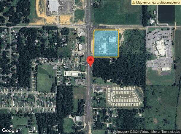
21890 State Highway 181, Fairhope, AL 36532
NEARBY LISTINGS FOR SALE OR LEASE
Property Detail
21890 State Highway 181
Daphne-Fairhope-Foley, AL
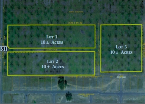
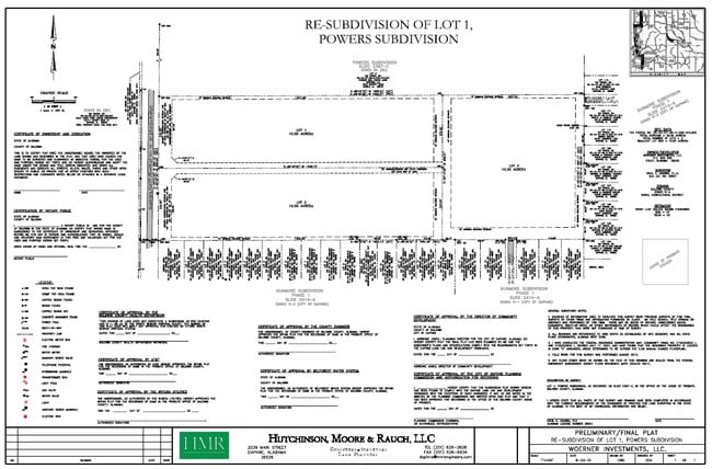
Usa Mapp Subdivision
46-01-11-0-000-001.526
7.9 AC LOT 1A USA MAPP SUBD RE-PLAT SLIDE 2821-F (SLIDE 2740 -E) SEC 11-T6S-R2E (WBOS) LEASE IN#1856964
Medicalbuilding
Baldwin
X
Alabama
01003C0661M
1a
0
7.90 AC
2024
Baldwin County
011103
Mobile
51,485 SF
DEMOGRAPHICS near 21890 State Highway 181
1 Mile
3 Mile
5 Mile
2024 Total Population
1,173
19,986
45,080
2029 Population
1,347
22,967
51,742
Pop Growth 2024-2029
+ 14.83%
+ 14.92%
+ 14.78%
Average Age
41
42
42
2024 Total Households
443
7,696
17,410
HH Growth 2024-2029
+ 14.67%
+ 14.53%
+ 14.41%
Median Household Inc
$84,346
$86,592
$78,377
Avg Household Size
2.60
2.50
2.50
2024 Avg HH Vehicles
2.00
2.00
2.00
Median Home Value
$278,457
$310,488
$319,144
Median Year Built
2006
2002
1999
Nearby Places
Map Layers
Map Styles
 Street
 Aerial
- Restaurants
- Banks
- Shops
- Fitness
- Groceries
PUBLIC TRANSPORTATION
AIRPORT
Mobile International
DRIVE
WALK
Distance
Mobile International
34 min
24.8 mi
Mobile Regional
DRIVE
WALK
Distance
Mobile Regional
57 min
38.5 mi
Freight Ports
Port of Mobile
DRIVE
WALK
Distance
Port of Mobile
29 min
21.4 mi
Nearby Properties
Address
Land Use
TOTAL SIZE
Lot Size
Zoning
Address
Land Use
TOTAL SIZE
Lot Size
Zoning
6,375 SF
21 AC
Address
Land Use
TOTAL SIZE
Lot Size
Zoning
1,273 SF
9.50 AC
Address
Land Use
TOTAL SIZE
Lot Size
Zoning
222,358 SF
51 AC
Address
Land Use
TOTAL SIZE
Lot Size
Zoning
74,683 SF
22 AC
Address
Land Use
TOTAL SIZE
Lot Size
Zoning
71,523 SF
20 AC
Address
Land Use
TOTAL SIZE
Lot Size
Zoning
53,038 SF
12 AC
Address
Land Use
TOTAL SIZE
Lot Size
Zoning
64,725 SF
8.70 AC
Address
Land Use
TOTAL SIZE
Lot Size
Zoning
64,884 SF
22 AC
Address
Land Use
TOTAL SIZE
Lot Size
Zoning
5,762 SF
10 AC
Address
Land Use
TOTAL SIZE
Lot Size
Zoning
8,196 SF
7.30 AC
Address
Land Use
TOTAL SIZE
Lot Size
Zoning
34,370 SF
0.92 AC
Address
Land Use
TOTAL SIZE
Lot Size
Zoning
14,188 SF
5.20 AC
Address
Land Use
TOTAL SIZE
Lot Size
Zoning
473 SF
9.90 AC
Address
Land Use
TOTAL SIZE
Lot Size
Zoning
51,000 SF
14 AC
Address
Land Use
TOTAL SIZE
Lot Size
Zoning
90,403 SF
12 AC
Address
Land Use
TOTAL SIZE
Lot Size
Zoning
36 AC
Address
Land Use
TOTAL SIZE
Lot Size
Zoning
9,123 SF
5.20 AC
Address
Land Use
TOTAL SIZE
Lot Size
Zoning
45,591 SF
4.30 AC
Address
Land Use
TOTAL SIZE
Lot Size
Zoning
53 AC
Address
Land Use
TOTAL SIZE
Lot Size
Zoning
2.69 AC
Address
Land Use
TOTAL SIZE
Lot Size
Zoning
79,053 SF
4 AC
Address
Land Use
TOTAL SIZE
Lot Size
Zoning
25,219 SF
29 AC
Address
Land Use
TOTAL SIZE
Lot Size
Zoning
9,840 SF
4.60 AC
Address
Land Use
TOTAL SIZE
Lot Size
Zoning
2,353 SF
61 AC
Address
Land Use
TOTAL SIZE
Lot Size
Zoning
11,000 SF
6.20 AC
Address
Land Use
TOTAL SIZE
Lot Size
Zoning
20,694 SF
7 AC
Address
Land Use
TOTAL SIZE
Lot Size
Zoning
35,553 SF
2.27 AC
Address
Land Use
TOTAL SIZE
Lot Size
Zoning
1,381 SF
2.56 AC
Address
Land Use
TOTAL SIZE
Lot Size
Zoning
20,672 SF
3.71 AC
The World's #1 Commercial Real Estate Marketplace
Connect with us
© 2026 CoStar Group
The information above has been obtained from sources believed reliable. While we do not doubt its accuracy we have not verified it and make no guarantee, warranty or representation about it. It is your responsibility to independently confirm its accuracy and completeness. Any projections, opinions, assumptions, or estimates used are for example only and do not represent the current or future performance of the property. The value of this transaction to you depends on tax and other factors which should be evaluated by your tax, financial, and legal advisors. You and your advisors should conduct a careful, independent investigation of the property to determine to your satisfaction the suitability of the property for your needs.