Property Record
219 Addison Rd, Glastonbury, CT 06033

Save to a Folder
{{folder.Name}}
{{folder.ListingIds.length}} Properties
{{folder.ListingIds.length}} Property
Create a New Folder
Property Detail
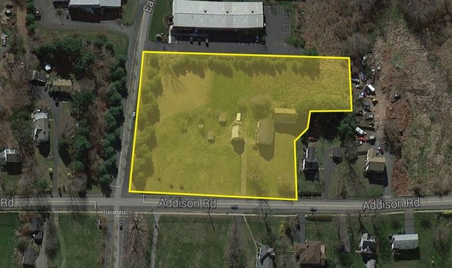
219 Addison Rd
GLAS-000004F-000020-W000017
Capitol
Commercialnec
Connecticut
PI
w0017
B and X Area of moderate flood hazard, usually the area between the limits of the 100-year and 500-year floods.
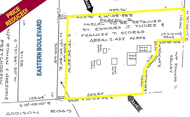
2.43 AC
2025
Glastonbury
2025
Hartford
520301
Hartford-West Hartford-East Hartford, CT
7,102 SF
NEARBY LISTINGS FOR SALE OR LEASE
-
-
View all Glastonbury listings for sale on LoopNet.com
DEMOGRAPHICS near 219 Addison Rd
1 mile
3 mile
5 mile
2025 Total Population
6,472
44,669
131,436
2030 Population
6,615
45,503
133,729
Pop Growth 2025-2030
+ 2.21%
+ 1.87%
+ 1.74%
Average Age
42
43
41
2025 Total Households
2,577
18,081
53,330
HH Growth 2025-2030
+ 2.21%
+ 1.88%
+ 1.78%
Median Household Inc
$104,652
$102,656
$83,168
Avg Household Size
2.40
2.40
2.40
2025 Avg HH Vehicles
2.00
2.00
2.00
Median Home Value
$340,171
$318,861
$292,142
Median Year Built
1975
1967
1962
Nearby Places
Map Layers
Map Styles
 Street
 Aerial
Layers
 Traffic
 Biking
Places
Listings with unknown addresses are not visible on the map
- Restaurants
- Banks
- Shops
- Fitness
- Groceries
PUBLIC TRANSPORTATION
COMMUTER RAIL
Drive
Walk
Distance
14 min
7.8 mi
Drive
Walk
Distance
14 min
7.8 mi
AIRPORT
Bradley International
Drive
Walk
Distance
Bradley International
43 min
23.8 mi
Tweed/New Haven
Drive
Walk
Distance
Tweed/New Haven
59 min
42.4 mi
Freight Ports
Port of New Haven
Drive
Walk
Distance
Port of New Haven
55 min
40.1 mi
SALE & LEASE HISTORY
LISTING DATE
SALE/LEASE

Sep 24, 2016
For Sale
Oct 15, 2018
For Sale
Nearby Properties
Address
Land Use
TOTAL SIZE
Lot Size
Zoning
Address
Land Use
TOTAL SIZE
Lot Size
Zoning
159 AC
RR
Address
Land Use
TOTAL SIZE
Lot Size
Zoning
149.23 AC
DDD1
Address
Land Use
TOTAL SIZE
Lot Size
Zoning
112.42 AC
DDD1
Address
Land Use
TOTAL SIZE
Lot Size
Zoning
49,219 SF
31.72 AC
Address
Land Use
TOTAL SIZE
Lot Size
Zoning
55.64 AC
Address
Land Use
TOTAL SIZE
Lot Size
Zoning
348,943 SF
51.21 AC
R-2
Address
Land Use
TOTAL SIZE
Lot Size
Zoning
188,454 SF
178.60 AC
A
Address
Land Use
TOTAL SIZE
Lot Size
Zoning
7.07 AC
PBD
Address
Land Use
TOTAL SIZE
Lot Size
Zoning
Address
Land Use
TOTAL SIZE
Lot Size
Zoning
11.95 AC
PAD
Address
Land Use
TOTAL SIZE
Lot Size
Zoning
15.12 AC
PAD
Address
Land Use
TOTAL SIZE
Lot Size
Zoning
Address
Land Use
TOTAL SIZE
Lot Size
Zoning
8.14 AC
Address
Land Use
TOTAL SIZE
Lot Size
Zoning
20.36 AC
B-1
Address
Land Use
TOTAL SIZE
Lot Size
Zoning
158,692 SF
2.89 AC
PAD
Address
Land Use
TOTAL SIZE
Lot Size
Zoning
105,294 SF
2.49 AC
PAD
Address
Land Use
TOTAL SIZE
Lot Size
Zoning
7.90 AC
Address
Land Use
TOTAL SIZE
Lot Size
Zoning
96,206 SF
2.83 AC
PAD
Address
Land Use
TOTAL SIZE
Lot Size
Zoning
3.06 AC
Address
Land Use
TOTAL SIZE
Lot Size
Zoning
71,728 SF
13.65 AC
Address
Land Use
TOTAL SIZE
Lot Size
Zoning
110,628 SF
28.81 AC
RR
Address
Land Use
TOTAL SIZE
Lot Size
Zoning
20,472 SF
10.59 AC
Address
Land Use
TOTAL SIZE
Lot Size
Zoning
5,603 SF
32.01 AC
Address
Land Use
TOTAL SIZE
Lot Size
Zoning
61,651 SF
9.98 AC
Address
Land Use
TOTAL SIZE
Lot Size
Zoning
50,648 SF
R-2
Address
Land Use
TOTAL SIZE
Lot Size
Zoning
57,457 SF
34.79 AC
Address
Land Use
TOTAL SIZE
Lot Size
Zoning
7.14 AC
Address
Land Use
TOTAL SIZE
Lot Size
Zoning
89,766 SF
11.18 AC
Address
Land Use
TOTAL SIZE
Lot Size
Zoning
55,045 SF
2.88 AC
Address
Land Use
TOTAL SIZE
Lot Size
Zoning
104,775 SF
12.57 AC
PI
The World's #1 Commercial Real Estate Marketplace
Connect with us
© 2026 CoStar Group
The information above has been obtained from sources believed reliable. While we do not doubt its accuracy we have not verified it and make no guarantee, warranty or representation about it. It is your responsibility to independently confirm its accuracy and completeness. Any projections, opinions, assumptions, or estimates used are for example only and do not represent the current or future performance of the property. The value of this transaction to you depends on tax and other factors which should be evaluated by your tax, financial, and legal advisors. You and your advisors should conduct a careful, independent investigation of the property to determine to your satisfaction the suitability of the property for your needs.