Property Record
219 Cedar St, Clintonville, WI 54929


NEARBY LISTINGS FOR SALE OR LEASE
-
-
View all Clintonville listings for sale on LoopNet.com
Property Detail
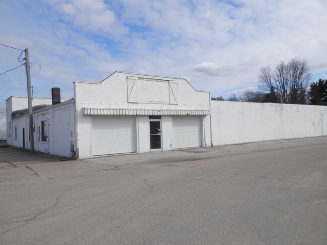
219 Cedar St
30 26 74 35
Clintons 3Rd Add
Commercialnec
SEC26 T25N R14E PRT SENE PRT BLKS 3&5 CLINTONS 3RD ADD DAF LT1 CSM V29P125 V374P292 V474P938 V589P118 EX V660P220 2.25A
X
Waupaca
55135C0232D
Wisconsin
2023
1
2024
2.25 AC
101100
Wisconsin North Area
18,184 SF
Other Market Areas
DEMOGRAPHICS near 219 Cedar St
1 Mile
3 Mile
5 Mile
2024 Total Population
3,783
5,888
7,249
2029 Population
3,810
5,935
7,274
Pop Growth 2024-2029
+ 0.71%
+ 0.80%
+ 0.34%
Average Age
42
42
43
2024 Total Households
1,735
2,654
3,189
HH Growth 2024-2029
+ 0.81%
+ 0.87%
+ 0.41%
Median Household Inc
$53,873
$55,596
$57,516
Avg Household Size
2.10
2.20
2.20
2024 Avg HH Vehicles
2.00
2.00
2.00
Median Home Value
$113,959
$126,383
$141,206
Median Year Built
1970
1973
1973
Nearby Places
Map Layers
Map Styles
 Street
 Aerial
- Restaurants
- Banks
- Shops
- Fitness
- Groceries
PUBLIC TRANSPORTATION
AIRPORT
Appleton International
DRIVE
WALK
Distance
Appleton International
52 min
34.2 mi
Freight Ports
Port Milwaukee
DRIVE
WALK
Distance
Port Milwaukee
162 min
133.8 mi
SALE & LEASE HISTORY
LISTING DATE
SALE/LEASE

Sep 24, 2016
For Sale
Jun 09, 2017
For Sale
Feb 07, 2019
For Sale
Dec 15, 2017
For Sale
Nearby Properties
Address
Land Use
TOTAL SIZE
Lot Size
Zoning
Address
Land Use
TOTAL SIZE
Lot Size
Zoning
19.95 AC
Address
Land Use
TOTAL SIZE
Lot Size
Zoning
Address
Land Use
TOTAL SIZE
Lot Size
Zoning
76,264 SF
6.27 AC
Address
Land Use
TOTAL SIZE
Lot Size
Zoning
30,128 SF
11.23 AC
Address
Land Use
TOTAL SIZE
Lot Size
Zoning
24,334 SF
22.62 AC
Address
Land Use
TOTAL SIZE
Lot Size
Zoning
40,661 SF
5.40 AC
Address
Land Use
TOTAL SIZE
Lot Size
Zoning
7.53 AC
Address
Land Use
TOTAL SIZE
Lot Size
Zoning
14.02 AC
Address
Land Use
TOTAL SIZE
Lot Size
Zoning
42 AC
A-G
Address
Land Use
TOTAL SIZE
Lot Size
Zoning
5,799 SF
2.50 AC
Address
Land Use
TOTAL SIZE
Lot Size
Zoning
20,876 SF
4.40 AC
Address
Land Use
TOTAL SIZE
Lot Size
Zoning
Address
Land Use
TOTAL SIZE
Lot Size
Zoning
16,580 SF
7.28 AC
Address
Land Use
TOTAL SIZE
Lot Size
Zoning
46,080 SF
3.39 AC
Address
Land Use
TOTAL SIZE
Lot Size
Zoning
29,670 SF
3.37 AC
Address
Land Use
TOTAL SIZE
Lot Size
Zoning
7.16 AC
Address
Land Use
TOTAL SIZE
Lot Size
Zoning
Address
Land Use
TOTAL SIZE
Lot Size
Zoning
9.52 AC
Address
Land Use
TOTAL SIZE
Lot Size
Zoning
33.22 AC
Address
Land Use
TOTAL SIZE
Lot Size
Zoning
13,650 SF
1.30 AC
Address
Land Use
TOTAL SIZE
Lot Size
Zoning
Address
Land Use
TOTAL SIZE
Lot Size
Zoning
14,348 SF
0.52 AC
Address
Land Use
TOTAL SIZE
Lot Size
Zoning
50,610 SF
8.52 AC
Address
Land Use
TOTAL SIZE
Lot Size
Zoning
21,618 SF
4.06 AC
Address
Land Use
TOTAL SIZE
Lot Size
Zoning
9.84 AC
Address
Land Use
TOTAL SIZE
Lot Size
Zoning
8,601 SF
1.77 AC
Address
Land Use
TOTAL SIZE
Lot Size
Zoning
Address
Land Use
TOTAL SIZE
Lot Size
Zoning
55.32 AC
Address
Land Use
TOTAL SIZE
Lot Size
Zoning
9,108 SF
97.07 AC
A-G
Address
Land Use
TOTAL SIZE
Lot Size
Zoning
0.17 AC
The World's #1 Commercial Real Estate Marketplace
Connect with us
© 2025 CoStar Group
The information above has been obtained from sources believed reliable. While we do not doubt its accuracy we have not verified it and make no guarantee, warranty or representation about it. It is your responsibility to independently confirm its accuracy and completeness. Any projections, opinions, assumptions, or estimates used are for example only and do not represent the current or future performance of the property. The value of this transaction to you depends on tax and other factors which should be evaluated by your tax, financial, and legal advisors. You and your advisors should conduct a careful, independent investigation of the property to determine to your satisfaction the suitability of the property for your needs.