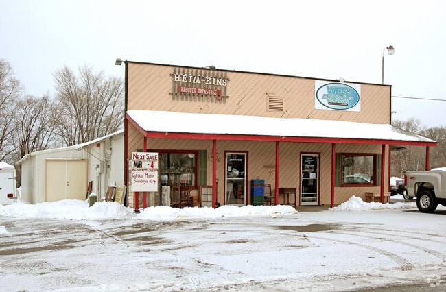
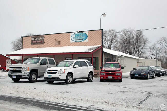
Property Record
219 E Cedar St, Saint Joseph, MN 56374

Property Detail
219 E Cedar St
84.53425.0004
.75A W 200' OF E 631.57' OF SE4NW4 LYING N OF HWY 52 & S OF RR LESS .07A FOR HWY CITY OF ST JOSEPH SECTION 10 TOWNSHIP 124
Officebuilding
Stearns
B and X Area of moderate flood hazard, usually the area between the limits of the 100-year and 500-year floods.
Minnesota
2025
0.75 AC
2025
Stearns County
011308
Minneapolis/St Paul
4,384 SF
St. Cloud, MN
NEARBY LISTINGS FOR SALE OR LEASE
DEMOGRAPHICS near 219 E Cedar St
1 mile
3 mile
5 mile
2025 Total Population
5,745
10,210
31,859
2030 Population
5,958
10,593
33,269
Pop Growth 2025-2030
+ 3.71%
+ 3.75%
+ 4.43%
Average Age
33
36
38
2025 Total Households
1,762
3,455
12,351
HH Growth 2025-2030
+ 4.31%
+ 4.20%
+ 4.60%
Median Household Inc
$65,951
$77,267
$71,518
Avg Household Size
2.40
2.40
2.40
2025 Avg HH Vehicles
2.00
2.00
2.00
Median Home Value
$272,465
$286,212
$278,505
Median Year Built
1992
1992
1997
Nearby Places
Map Layers
Map Styles
 Street
 Aerial
Transit
 Traffic
 Biking
Places
Listings with unknown addresses are not visible on the map
- Restaurants
- Banks
- Shops
- Fitness
- Groceries
PUBLIC TRANSPORTATION
COMMUTER RAIL
Drive
Walk
Distance
17 min
8.9 mi
Nearby Properties
Address
Land Use
TOTAL SIZE
Lot Size
Zoning
Address
Land Use
TOTAL SIZE
Lot Size
Zoning
52,983 SF
22 AC
Address
Land Use
TOTAL SIZE
Lot Size
Zoning
148,150 SF
71.46 AC
Address
Land Use
TOTAL SIZE
Lot Size
Zoning
19.06 AC
Address
Land Use
TOTAL SIZE
Lot Size
Zoning
269,390 SF
15.77 AC
Address
Land Use
TOTAL SIZE
Lot Size
Zoning
51.70 AC
PL20B2
Address
Land Use
TOTAL SIZE
Lot Size
Zoning
Address
Land Use
TOTAL SIZE
Lot Size
Zoning
3,088 SF
67.89 AC
PL20B1
Address
Land Use
TOTAL SIZE
Lot Size
Zoning
33,796 SF
4.83 AC
Address
Land Use
TOTAL SIZE
Lot Size
Zoning
13,219 SF
2.19 AC
Address
Land Use
TOTAL SIZE
Lot Size
Zoning
27,694 SF
7.17 AC
Address
Land Use
TOTAL SIZE
Lot Size
Zoning
4.15 AC
Address
Land Use
TOTAL SIZE
Lot Size
Zoning
Address
Land Use
TOTAL SIZE
Lot Size
Zoning
Address
Land Use
TOTAL SIZE
Lot Size
Zoning
15,545 SF
25.34 AC
Address
Land Use
TOTAL SIZE
Lot Size
Zoning
39,604 SF
11.29 AC
Address
Land Use
TOTAL SIZE
Lot Size
Zoning
100,010 SF
10 AC
Address
Land Use
TOTAL SIZE
Lot Size
Zoning
69,151 SF
4.34 AC
PUD32
Address
Land Use
TOTAL SIZE
Lot Size
Zoning
16,562 SF
3.70 AC
Address
Land Use
TOTAL SIZE
Lot Size
Zoning
39,544 SF
6.92 AC
Address
Land Use
TOTAL SIZE
Lot Size
Zoning
19,800 SF
10 AC
Address
Land Use
TOTAL SIZE
Lot Size
Zoning
Address
Land Use
TOTAL SIZE
Lot Size
Zoning
Address
Land Use
TOTAL SIZE
Lot Size
Zoning
Address
Land Use
TOTAL SIZE
Lot Size
Zoning
141,210 SF
16.73 AC
I3
Address
Land Use
TOTAL SIZE
Lot Size
Zoning
13,291 SF
6.05 AC
Address
Land Use
TOTAL SIZE
Lot Size
Zoning
Address
Land Use
TOTAL SIZE
Lot Size
Zoning
71,724 SF
15.99 AC
Address
Land Use
TOTAL SIZE
Lot Size
Zoning
21,116 SF
0.74 AC
Address
Land Use
TOTAL SIZE
Lot Size
Zoning
35,033 SF
49.17 AC
Address
Land Use
TOTAL SIZE
Lot Size
Zoning
14,172 SF
3.76 AC
The World's #1 Commercial Real Estate Marketplace
Connect with us
© 2026 CoStar Group
The information above has been obtained from sources believed reliable. While we do not doubt its accuracy we have not verified it and make no guarantee, warranty or representation about it. It is your responsibility to independently confirm its accuracy and completeness. Any projections, opinions, assumptions, or estimates used are for example only and do not represent the current or future performance of the property. The value of this transaction to you depends on tax and other factors which should be evaluated by your tax, financial, and legal advisors. You and your advisors should conduct a careful, independent investigation of the property to determine to your satisfaction the suitability of the property for your needs.