Property Record
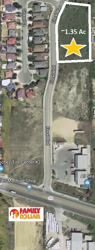
219 Floral Blvd, Laredo, TX 78043


Property Detail
219 Floral Blvd
Laredo, TX
LAS FLORES, BLOCK 5, LOT 1-B, PHASE 2
365930
WEBB
Residentialacreage
Texas
B1
1-b
B and X Area of moderate flood hazard, usually the area between the limits of the 100-year and 500-year floods.
1.35 AC
2024
Texas South Area
2025
Other Market Areas
001003
NEARBY LISTINGS FOR SALE OR LEASE
DEMOGRAPHICS near 219 Floral Blvd
1 mile
3 mile
5 mile
2025 Total Population
7,241
58,857
140,975
2030 Population
7,508
60,174
144,510
Pop Growth 2025-2030
+ 3.69%
+ 2.24%
+ 2.51%
Average Age
30
33
34
2025 Total Households
1,915
16,330
40,048
HH Growth 2025-2030
+ 3.92%
+ 2.37%
+ 2.60%
Median Household Inc
$89,552
$62,080
$52,837
Avg Household Size
3.80
3.50
3.40
2025 Avg HH Vehicles
3.00
2.00
2.00
Median Home Value
$213,575
$183,711
$175,170
Median Year Built
2007
1998
1993
Nearby Places
Map Layers
Map Styles
 Street
 Aerial
Layers
 Traffic
 Biking
Places
Listings with unknown addresses are not visible on the map
- Restaurants
- Banks
- Shops
- Fitness
- Groceries
PUBLIC TRANSPORTATION
AIRPORT
Laredo International
Drive
Walk
Distance
Laredo International
12 min
5.5 mi
SALE & LEASE HISTORY
LISTING DATE
SALE/LEASE

Jul 08, 2018
For Sale
Nearby Properties
Address
Land Use
TOTAL SIZE
Lot Size
Zoning
Address
Land Use
TOTAL SIZE
Lot Size
Zoning
423,977 SF
1.27 AC
R2
Address
Land Use
TOTAL SIZE
Lot Size
Zoning
310,346 SF
87.65 AC
R1A
Address
Land Use
TOTAL SIZE
Lot Size
Zoning
347,773 SF
49.74 AC
R1
Address
Land Use
TOTAL SIZE
Lot Size
Zoning
165,608 SF
28.50 AC
R2
Address
Land Use
TOTAL SIZE
Lot Size
Zoning
231,146 SF
1.77 AC
R1
Address
Land Use
TOTAL SIZE
Lot Size
Zoning
380,420 SF
9.18 AC
B3
Address
Land Use
TOTAL SIZE
Lot Size
Zoning
169,339 SF
28 AC
Address
Land Use
TOTAL SIZE
Lot Size
Zoning
108,994 SF
15.39 AC
Address
Land Use
TOTAL SIZE
Lot Size
Zoning
183,795 SF
10.36 AC
R2
Address
Land Use
TOTAL SIZE
Lot Size
Zoning
107,824 SF
13.38 AC
R1
Address
Land Use
TOTAL SIZE
Lot Size
Zoning
96,665 SF
12.03 AC
R1A
Address
Land Use
TOTAL SIZE
Lot Size
Zoning
102,815 SF
2.23 AC
Address
Land Use
TOTAL SIZE
Lot Size
Zoning
95,769 SF
10 AC
R1
Address
Land Use
TOTAL SIZE
Lot Size
Zoning
79,764 SF
30 AC
R1
Address
Land Use
TOTAL SIZE
Lot Size
Zoning
95,612 SF
10 AC
R1A
Address
Land Use
TOTAL SIZE
Lot Size
Zoning
136,195 SF
9.50 AC
Address
Land Use
TOTAL SIZE
Lot Size
Zoning
90,400 SF
1.77 AC
R3
Address
Land Use
TOTAL SIZE
Lot Size
Zoning
70,843 SF
20 AC
Address
Land Use
TOTAL SIZE
Lot Size
Zoning
81,470 SF
36.89 AC
Address
Land Use
TOTAL SIZE
Lot Size
Zoning
57,690 SF
8.98 AC
B4
Address
Land Use
TOTAL SIZE
Lot Size
Zoning
42,001 SF
6.01 AC
R1
Address
Land Use
TOTAL SIZE
Lot Size
Zoning
78,108 SF
14.80 AC
Address
Land Use
TOTAL SIZE
Lot Size
Zoning
221,975 SF
24.16 AC
B3
Address
Land Use
TOTAL SIZE
Lot Size
Zoning
124,154 SF
10.60 AC
B3
Address
Land Use
TOTAL SIZE
Lot Size
Zoning
42.64 AC
B3
Address
Land Use
TOTAL SIZE
Lot Size
Zoning
100,697 SF
1.77 AC
R2
Address
Land Use
TOTAL SIZE
Lot Size
Zoning
72,112 SF
14.75 AC
B4
Address
Land Use
TOTAL SIZE
Lot Size
Zoning
27,912 SF
18.98 AC
AG
Address
Land Use
TOTAL SIZE
Lot Size
Zoning
105,253 SF
16.02 AC
M1
Address
Land Use
TOTAL SIZE
Lot Size
Zoning
70,750 SF
9.42 AC
The World's #1 Commercial Real Estate Marketplace
Connect with us
© 2026 CoStar Group
The information above has been obtained from sources believed reliable. While we do not doubt its accuracy we have not verified it and make no guarantee, warranty or representation about it. It is your responsibility to independently confirm its accuracy and completeness. Any projections, opinions, assumptions, or estimates used are for example only and do not represent the current or future performance of the property. The value of this transaction to you depends on tax and other factors which should be evaluated by your tax, financial, and legal advisors. You and your advisors should conduct a careful, independent investigation of the property to determine to your satisfaction the suitability of the property for your needs.